- My Forums
- Tiger Rant
- LSU Recruiting
- SEC Rant
- Saints Talk
- Pelicans Talk
- More Sports Board
- Fantasy Sports
- Golf Board
- Soccer Board
- O-T Lounge
- Tech Board
- Home/Garden Board
- Outdoor Board
- Health/Fitness Board
- Movie/TV Board
- Book Board
- Music Board
- Political Talk
- Money Talk
- Fark Board
- Gaming Board
- Travel Board
- Food/Drink Board
- Ticket Exchange
- TD Help Board
Customize My Forums- View All Forums
- Show Left Links
- Topic Sort Options
- Trending Topics
- Recent Topics
- Active Topics
Started By
Message
Severe weather thread. 11-5-18
Posted on 11/5/18 at 4:22 pm
Posted on 11/5/18 at 4:22 pm
Tornado warning, Confirmed sighting near Natchitoches moving NE at 35 mph.
 5
5

Posted on 11/5/18 at 4:23 pm to Jim Rockford
There’s a second warning near Toledo Bend, just north of Many.
Posted on 11/5/18 at 4:25 pm to Jim Rockford
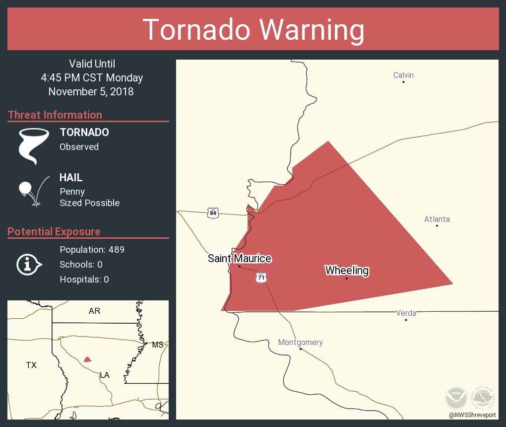
.A TORNADO WARNING REMAINS IN EFFECT UNTIL 445 PM CST FOR
NORTHWESTERN GRANT...CENTRAL NATCHITOCHES AND SOUTHWESTERN WINN
PARISHES...
At 420 PM CST, a confirmed tornado was located 7 miles northwest of
Montgomery, or 7 miles east of Natchitoches, moving northeast at 35
mph. A tornado is on the ground at this time. Take cover
immediately.
HAZARD...Damaging tornado.
SOURCE...Radar confirmed tornado.
IMPACT...Flying debris will be dangerous to those caught without
shelter. Mobile homes will be damaged or destroyed. Damage
to roofs, windows, and vehicles will occur. Tree damage is
likely.
Locations impacted include...
St. Maurice.
TORNADO...OBSERVED
HAIL...<.75IN
Posted on 11/5/18 at 4:29 pm to lsuman25
Two very obvious tornado signatures on radar.

Posted on 11/5/18 at 4:30 pm to slackster
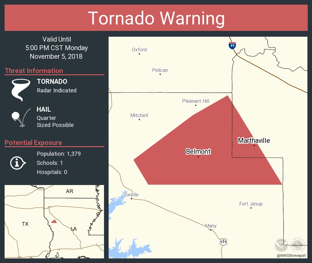
damn a donut hole in the storm near Zwolle.
Posted on 11/5/18 at 4:31 pm to slackster
quote:
Two very obvious tornado signatures on radar.
that cell by Natchitoches was super dirty looking just as it went south of downtown Natchitoches
Posted on 11/5/18 at 4:31 pm to lsuman25
That Zwolle tornado looks scary right now on radar.
Posted on 11/5/18 at 4:31 pm to lsuman25
Definite couplet on that Zwolle cell.
Posted on 11/5/18 at 4:31 pm to rt3

Posted on 11/5/18 at 4:32 pm to Duke
Hows it looking for the Alexandria area tonight? Last Thursday was rough.
Posted on 11/5/18 at 4:33 pm to rt3
Posted on 11/5/18 at 4:33 pm to slackster
Cells have started off pretty spaced out and parameters are pretty impressive, esp considering N. Louisiana was only given a "Slight" by SPC. Those cells could be trouble for while as they track NE.
Posted on 11/5/18 at 4:34 pm to S
quote:
Hows it looking for the Alexandria area tonight?
Pretty good, best features are well north of the area. Just keep an eye out for those rouge cells. The real show looks more like the Ohio Valley.
Posted on 11/5/18 at 4:34 pm to rt3
unwarned cell south of Shreveport headed towards Ringgold may need a warning cell
Posted on 11/5/18 at 4:34 pm to rt3
These tornado warning graphics from Twitter are how I learn about new parts of LA.
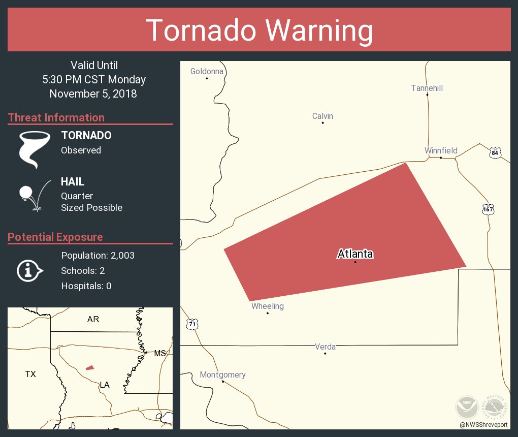
Who knew there was an Atlanta, LA?
Who knew there was an Atlanta, LA?
Posted on 11/5/18 at 4:36 pm to rds dc
quote:
NWS Shreveport @NWSShreveport
Folks near and south of Pleasant Hill need to take cover! #lawx
quote:
NWS Shreveport @NWSShreveport
Folks near Calvin Atlanta, and Winnfield need to be taking cover now! #lawx
Posted on 11/5/18 at 4:36 pm to rt3
The cell very near Coushatta and headed to Martin needs to be watched.
Posted on 11/5/18 at 4:39 pm to slackster
quote:
Two very obvious tornado signatures on radar.
Define obvious.
Posted on 11/5/18 at 4:39 pm to slackster
that cell splitting the difference between Many & Pleasant Hill is getting nasty with the quickness
Posted on 11/5/18 at 4:40 pm to BHM

 Page 1 of 6

Popular
Back to top