- My Forums
- Tiger Rant
- LSU Recruiting
- SEC Rant
- Saints Talk
- Pelicans Talk
- More Sports Board
- Fantasy Sports
- Golf Board
- Soccer Board
- O-T Lounge
- Tech Board
- Home/Garden Board
- Outdoor Board
- Health/Fitness Board
- Movie/TV Board
- Book Board
- Music Board
- Political Talk
- Money Talk
- Fark Board
- Gaming Board
- Travel Board
- Food/Drink Board
- Ticket Exchange
- TD Help Board
Customize My Forums- View All Forums
- Show Left Links
- Topic Sort Options
- Trending Topics
- Recent Topics
- Active Topics
Started By
Message
re: 5/6 Oklahoma/Kansas severe weather - High Risk- PDS Tor Watch
Posted on 5/6/24 at 2:17 pm to LegendInMyMind

Posted on 5/6/24 at 2:17 pm to LegendInMyMind
I don’t mean apples to apples. I mean from a probability standpoint.
 2
2


Posted on 5/6/24 at 2:22 pm to LSUGrrrl
quote:
I don’t mean apples to apples. I mean from a probability standpoint.
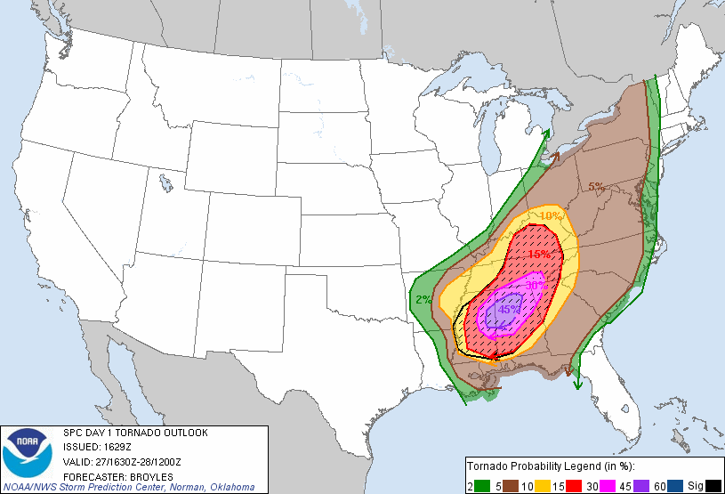
When it comes to tornadoes, April 27, 2011 had an ultra-rare 45% probability of tornadoes in the high risk area. Meaning there was a 45% chance of a tornado within 25 miles of any given point in that area.
*This graphic is from 4/27/11.*
This post was edited on 5/6/24 at 2:39 pm
Posted on 5/6/24 at 2:26 pm to LSUGrrrl
quote:
I don’t mean apples to apples. I mean from a probability standpoint.
They're both High Risk, so you have that. Duration of the most threatening supercell storms and how the setup should play out is entirely different. Shear was much higher on 4/27. There was enough CIN and the shear vector across a large geographical area was perfect so that it squashed any chance of those storms on 4/27 lining out. We don't have that with this setup. The window for discrete supercells is smaller than 4/27, these storms should line out tonight and could become a significant wind event as the line moves east into the night. The window where we will likely see discrete supercells fire has a very high ceiling.

 Page 1 of 1


Popular
Back to top