- My Forums
- Tiger Rant
- LSU Recruiting
- SEC Rant
- Saints Talk
- Pelicans Talk
- More Sports Board
- Fantasy Sports
- Golf Board
- Soccer Board
- O-T Lounge
- Tech Board
- Home/Garden Board
- Outdoor Board
- Health/Fitness Board
- Movie/TV Board
- Book Board
- Music Board
- Political Talk
- Money Talk
- Fark Board
- Gaming Board
- Travel Board
- Food/Drink Board
- Ticket Exchange
- TD Help Board
Customize My Forums- View All Forums
- Show Left Links
- Topic Sort Options
- Trending Topics
- Recent Topics
- Active Topics
Started By
Message
re: Random Google Maps browsing of the day.
Posted on 5/10/24 at 6:37 pm to Cosmo
Posted on 5/10/24 at 6:37 pm to Cosmo
In the early days of commercial aviation and air mail service, airplane pilots relied upon light beacons and enormous concrete arrows on the ground to find their way across the country. These navigation aids were built by the Department of Commerce in the 1920s and early 1930s to promote air travel.
Eventually more than 1500 beacons were erected. They were spaced about 10 to 20 miles apart along designated air routes.
The 1st picture is just outside of Albuquerque.

/https://tf-cmsv2-smithsonianmag-media.s3.amazonaws.com/filer/ec/ca/eccab148-56bc-4bc2-b48a-d0d91cc73548/24g_fm2016_silverzone-drone_still_01_live.jpg)
Eventually more than 1500 beacons were erected. They were spaced about 10 to 20 miles apart along designated air routes.
The 1st picture is just outside of Albuquerque.
 1
1

Posted on 5/10/24 at 6:50 pm to Apache
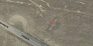
There is a visible navigation arrow just south of Las Vegas in Enterprise NV. It is just east of Interstate 15 near Combat Zone Paintball.
I challenge you to find it.
I challenge you to find it.

 Page 1 of 1


Popular
Back to top