- My Forums
- Tiger Rant
- LSU Recruiting
- SEC Rant
- Saints Talk
- Pelicans Talk
- More Sports Board
- Fantasy Sports
- Golf Board
- Soccer Board
- O-T Lounge
- Tech Board
- Home/Garden Board
- Outdoor Board
- Health/Fitness Board
- Movie/TV Board
- Book Board
- Music Board
- Political Talk
- Money Talk
- Fark Board
- Gaming Board
- Travel Board
- Food/Drink Board
- Ticket Exchange
- TD Help Board
Customize My Forums- View All Forums
- Show Left Links
- Topic Sort Options
- Trending Topics
- Recent Topics
- Active Topics
Started By
Message

How to read a flood elevation certificate and relate to the river?
Posted on 12/31/15 at 12:45 pm

Posted on 12/31/15 at 12:45 pm
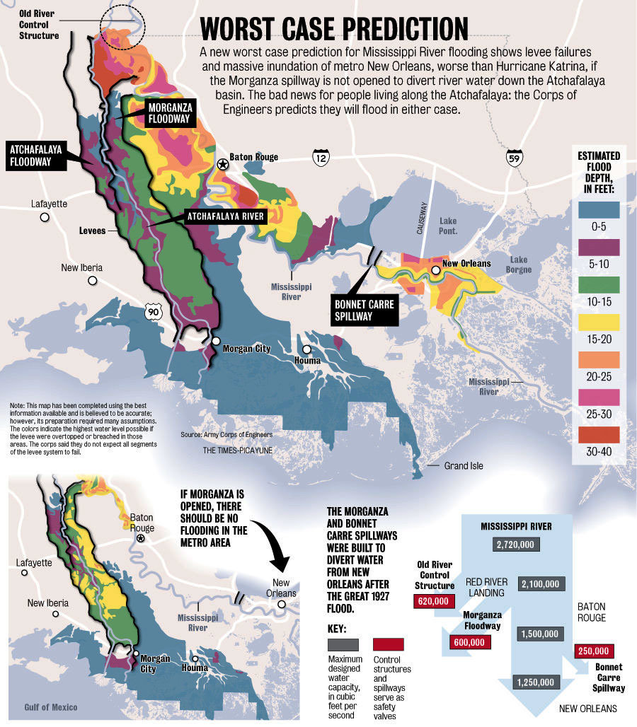
Anyone know how to read a flood elevation certificate and relate it to the scary map below from 2011? In particular, can you relate the base flood elevation reported on the cert to the estimated flood depth in the map? What about the elevation reference mark and things like top of bottom floor? Here are some example data:
Base flood elevation: 16
Elevation reference mark: 16.75
Top of bottom floor: 19
Here's the scary map from 2011. How does a 15-20 flood depth relate to the above data? Is it so simple as to be directly comparable? And what about flood stage for the river? It's 35', and I know that's the level at which flooding would occur without the levee, but that number doesn't seem directly comparable.
 4
4


Posted on 12/31/15 at 12:49 pm to Spock's Eyebrow
quote:
Here's the scary map from 2011. How does a 15-20 flood depth relate to the above data?
It means that if the levees failed or were breached, there would be 15-20 feet of water in that location.
At least that's how I interpret it.

Posted on 12/31/15 at 1:01 pm to Spock's Eyebrow
Your reference mark is 9 inches above base flood elevation
Posted on 12/31/15 at 1:02 pm to bencoleman
Your tof is 2ft3 inches above reference mark
Posted on 12/31/15 at 1:31 pm to Spock's Eyebrow
All of those elevations are meant to be x amount of feet above mean sea level
Posted on 12/31/15 at 1:38 pm to bencoleman
.0817=1 inch
.1667=2 inches
.25=3 inches
.3333=4 inches
.4216=5 inches
.50=6 inches
.5814=7 inches
.6667=8 inches
.75=9 inches
.1083=10 inches
.9216=11 inches
.1667=2 inches
.25=3 inches
.3333=4 inches
.4216=5 inches
.50=6 inches
.5814=7 inches
.6667=8 inches
.75=9 inches
.1083=10 inches
.9216=11 inches
Posted on 12/31/15 at 2:15 pm to Spock's Eyebrow
quote:
Anyone know how to read a flood elevation certificate and relate it to the scary map below from 2011? In particular, can you relate the base flood elevation reported on the cert to the estimated flood depth in the map? What about the elevation reference mark and things like top of bottom floor? Here are some example data:
Base flood elevation: 16
Elevation reference mark: 16.75
Top of bottom floor: 19
Here's the scary map from 2011. How does a 15-20 flood depth relate to the above data? Is it so simple as to be directly comparable? And what about flood stage for the river? It's 35', and I know that's the level at which flooding would occur without the levee, but that number doesn't seem directly comparable.
The Base Flood Elevation (BFE) is the 100-year flood water surface elevation. It is in feet above sea level.
The worst case prediction flooding depicted is not the same as the 100-yr flood event. It will be much worse.
The "Estimated Flood Depth in Feet" is the difference between the water surface elevation during the worst case prediction and the ground surface in that location.
Posted on 12/31/15 at 2:51 pm to glb
quote:quote:
Base flood elevation: 16
Elevation reference mark: 16.75
Top of bottom floor: 19
The Base Flood Elevation (BFE) is the 100-year flood water surface elevation. It is in feet above sea level.
The worst case prediction flooding depicted is not the same as the 100-yr flood event. It will be much worse.
The "Estimated Flood Depth in Feet" is the difference between the water surface elevation during the worst case prediction and the ground surface in that location.
To be above that 15-20 foot flood, the top of bottom floor would need to be what?
And for the BFE, what is its flood depth measured the same way as on that worst-case map (distance above ground surface in that location)?

Posted on 12/31/15 at 2:58 pm to glb
Correct.
Find out the natural ground elevation at your house. Then add the depth from the scary map to it. If it's still below your slab elevation, you're good. Of course the problem is that map is very generalized and does not account for varying natural ground depths.
Find out the natural ground elevation at your house. Then add the depth from the scary map to it. If it's still below your slab elevation, you're good. Of course the problem is that map is very generalized and does not account for varying natural ground depths.
Posted on 12/31/15 at 3:00 pm to LSUJuice
The question you really want to answer is, "to what elevation above sea level will the water rise?" And that's what you'd compare to your elevation certificate.

 Page 1 of 1


Popular
Back to top