- My Forums
- Tiger Rant
- LSU Recruiting
- SEC Rant
- Saints Talk
- Pelicans Talk
- More Sports Board
- Fantasy Sports
- Golf Board
- Soccer Board
- O-T Lounge
- Tech Board
- Home/Garden Board
- Outdoor Board
- Health/Fitness Board
- Movie/TV Board
- Book Board
- Music Board
- Political Talk
- Money Talk
- Fark Board
- Gaming Board
- Travel Board
- Food/Drink Board
- Ticket Exchange
- TD Help Board
Customize My Forums- View All Forums
- Show Left Links
- Topic Sort Options
- Trending Topics
- Recent Topics
- Active Topics
Started By
Message

 1
1

Posted on 5/18/17 at 3:17 pm to GEAUXmedic
Damnn down in TX

Posted on 5/18/17 at 3:20 pm to GEAUXmedic
watching the Aaron Jayjack cam on Severe Studios
some idiot stormchaser just blocked him in while he was off the road trying to get a shot of the storm... right in front of his camera
some idiot stormchaser just blocked him in while he was off the road trying to get a shot of the storm... right in front of his camera
Posted on 5/18/17 at 3:22 pm to GEAUXmedic
That tx storm^


Posted on 5/18/17 at 3:22 pm to rds dc
quote:
Cell SW of Crowell, TX could be trouble. Total clear inflow channel.
This cell is now likely producing a violent tornado.
Posted on 5/18/17 at 3:24 pm to GEAUXmedic
Save this image if you ever need a textbook image of tornado on radar.


Posted on 5/18/17 at 3:24 pm to GEAUXmedic
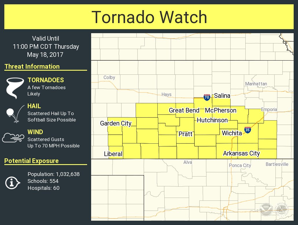
Well, they didn't go PDS on the watch in south Kansas.
Posted on 5/18/17 at 3:26 pm to Roll Tide Ravens
Posted on 5/18/17 at 3:26 pm to rds dc
quote:
This cell is now likely producing a violent tornado.

Posted on 5/18/17 at 3:26 pm to Roll Tide Ravens
quote:
Well, they didn't go PDS on the watch in south Kansas.
Interesting... IMO PDS is just quibbling over semantics at this point. A watch is a watch.
Posted on 5/18/17 at 3:29 pm to GEAUXmedic
quote:
Interesting... IMO PDS is just quibbling over semantics at this point. A watch is a watch.
True. They may have done this because storms may be too clustered once they move up into Kansas.
Posted on 5/18/17 at 3:32 pm to GEAUXmedic
Hail spike!

Posted on 5/18/17 at 3:32 pm to Roll Tide Ravens
quote:
NWS Norman @NWSNorman
Here's a look at NWSChat that we use to communicate with our TV and emergency management partners. Critical communication tool! #iwt

ETA: NWS Norman is in charge of that Texas storm y'all are following
This post was edited on 5/18/17 at 3:33 pm
Posted on 5/18/17 at 3:34 pm to rds dc
You know you have a powerful supercell when you have the v shape, or "flying eagle", on the leading edge of the storm.

Posted on 5/18/17 at 3:36 pm to Roll Tide Ravens
Scratch that, they have changed it to a PDS.
U.S. Tornadoes? @USTornadoes 2m2 minutes ago
South and central KS tornado watch has been updated to 90/80 tornado probabilities and is a PDS watch.
U.S. Tornadoes? @USTornadoes 2m2 minutes ago
South and central KS tornado watch has been updated to 90/80 tornado probabilities and is a PDS watch.
Posted on 5/18/17 at 3:36 pm to Roll Tide Ravens
quote:
True. They may have done this because storms may be too clustered once they move up into Kansas.
Yea, storms are pretty messy up that way and the surface low is farther south than expected. That might work in tandem to keep the KS threat down some. However, never bet against KS in May.
Posted on 5/18/17 at 3:36 pm to rt3

Posted on 5/18/17 at 3:37 pm to GEAUXmedic

Posted on 5/18/17 at 3:37 pm to Roll Tide Ravens
Storms in Oklahoma are becoming more and more clustered. Could certainly limit tornado thread.
Posted on 5/18/17 at 3:38 pm to GEAUXmedic
video on the TWC just a moment ago showed crazy motion with the storm new New Cordell Oklahoma.

 Page 4 of 7

Popular
Back to top