- My Forums
- Tiger Rant
- LSU Recruiting
- SEC Rant
- Saints Talk
- Pelicans Talk
- More Sports Board
- Fantasy Sports
- Golf Board
- Soccer Board
- O-T Lounge
- Tech Board
- Home/Garden Board
- Outdoor Board
- Health/Fitness Board
- Movie/TV Board
- Book Board
- Music Board
- Political Talk
- Money Talk
- Fark Board
- Gaming Board
- Travel Board
- Food/Drink Board
- Ticket Exchange
- TD Help Board
Customize My Forums- View All Forums
- Show Left Links
- Topic Sort Options
- Trending Topics
- Recent Topics
- Active Topics
Started By
Message
re: Tornado Thread: HIGH RISK in Oklahoma and Kansas
Posted on 5/18/17 at 1:56 pm to GEAUXmedic
Posted on 5/18/17 at 1:56 pm to GEAUXmedic
Waiting to see if they put out a 45% hatched tor risk. It's possible is storms end up more discrete.
 1
1

Posted on 5/18/17 at 1:58 pm to GEAUXmedic
Tornado warning imminent IMO
edit: yep.

edit: yep.
quote:
BULLETIN - EAS ACTIVATION REQUESTED Tornado Warning National Weather Service Norman OK 158 PM CDT THU MAY 18 2017 The National Weather Service in Norman has issued a * Tornado Warning for... Northwestern Jackson County in southwestern Oklahoma... West central Kiowa County in southwestern Oklahoma... Central Greer County in southwestern Oklahoma... East central Harmon County in southwestern Oklahoma... * Until 245 PM CDT * At 158 PM CDT, a severe thunderstorm capable of producing a tornado was located near Duke, moving northeast at 40 mph. HAZARD...Tornado and hail up to two inches in diameter. SOURCE...Radar indicated rotation. IMPACT...Flying debris will be dangerous to those caught without shelter. Mobile homes will be damaged or destroyed. Damage to roofs, windows, and vehicles will occur. Tree damage is likely. * Locations impacted include... Mangum, Granite, Willow, Duke, Brinkman, Hester, Altus-Lugert Lake and McQueen.
This post was edited on 5/18/17 at 1:59 pm

Posted on 5/18/17 at 2:01 pm to Roll Tide Ravens
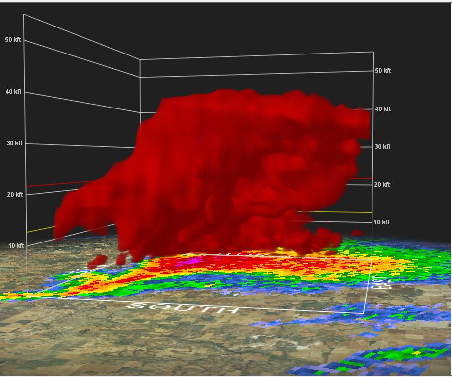
First tornado warning of the day, storm organized quickly:

Posted on 5/18/17 at 2:02 pm to GEAUXmedic
Does the green band in the second photo show the rotation?
Posted on 5/18/17 at 2:05 pm to chinhoyang
What you look for is called a couplet, when you have bright red and bright green next to each other. You have reds showing velocity moving away from the radar site, and green which are moving towards. The brighter the color the higher the velocity. So even when velocities are low, you can kinda tell where rotation is beginning, you can also tell how strong it is, and if it is broad or tightened. Also paired with base reflectivity and correlation coefficient radar you can see other features like hooks and debris balls to confirm whether there may be a tornado or not.
Posted on 5/18/17 at 2:06 pm to chinhoyang
quote:
Does the green band in the second photo show the rotation?
The bright reds and greens do. When they are close together, or sometimes swirled together it indicates rotation. Red is wind moving away from the radar, green is wind moving toward the radar. The tighter together they are, the stronger the rotation. When the swirl together, it usually is an indication of very strong rotation, possibly producing a significant tornado.
This post was edited on 5/18/17 at 2:09 pm
Posted on 5/18/17 at 2:07 pm to GEAUXmedic
Confirmed tornado

Posted on 5/18/17 at 2:08 pm to GEAUXmedic

Posted on 5/18/17 at 2:09 pm to GEAUXmedic
looks out in the middle of nowhere.
Posted on 5/18/17 at 2:11 pm to Roll Tide Ravens
quote:
storm organized quickly:
Explosive atmosphere today
Posted on 5/18/17 at 2:12 pm to 50_Tiger
Couplet getting tighter
Posted on 5/18/17 at 2:13 pm to rds dc
Damn, this is on our family farm.
Posted on 5/18/17 at 2:13 pm to rds dc
Posted on 5/18/17 at 2:15 pm to LilDeuceCoupe
quote:
Damn, this is on our family farm.
Geeez baw I hope everything works out okay for yall.
Posted on 5/18/17 at 2:16 pm to GEAUXmedic
Posted on 5/18/17 at 2:17 pm to GEAUXmedic
tornado has dissipated for now
Posted on 5/18/17 at 2:18 pm to Roll Tide Ravens
Not looking as good on radar now, KFOR live video showed it roping out and lifting,
Posted on 5/18/17 at 2:20 pm to GEAUXmedic
It's hard to bring myself to watch KFOR and Mike Morgan. I'll never be able to let go of him telling people to get in the car and drive south during the Moore tornado in 2013.
Posted on 5/18/17 at 2:22 pm to Roll Tide Ravens
"It's May 3rd all over again" .. he's such a chode. He also likes to predict intensities of tornadoes before they happen.

Posted on 5/18/17 at 2:23 pm to GEAUXmedic
quote:
He also likes to predict intensities of tornadoes before they happen.
So like Peej, but with a transmission tower?

 Page 2 of 7

Popular
Back to top