- My Forums
- Tiger Rant
- LSU Recruiting
- SEC Rant
- Saints Talk
- Pelicans Talk
- More Sports Board
- Fantasy Sports
- Golf Board
- Soccer Board
- O-T Lounge
- Tech Board
- Home/Garden Board
- Outdoor Board
- Health/Fitness Board
- Movie/TV Board
- Book Board
- Music Board
- Political Talk
- Money Talk
- Fark Board
- Gaming Board
- Travel Board
- Food/Drink Board
- Ticket Exchange
- TD Help Board
Customize My Forums- View All Forums
- Show Left Links
- Topic Sort Options
- Trending Topics
- Recent Topics
- Active Topics
Started By
Message
Tornado Thread: HIGH RISK in Oklahoma and Kansas
Posted on 5/18/17 at 4:39 am

Posted on 5/18/17 at 4:39 am
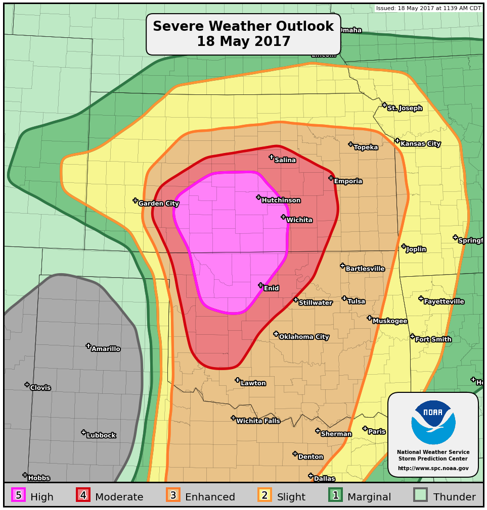
Day 1 Convective outlook:

(Zoomed in look at Convective outlook)

Tornado probabilities:

Remarkably, this is the first high risk day in Oklahoma since 2012, meaning that monster tornadoes such as the Moore and El Reno, OK tornadoes happened on non-high risk days.
(Zoomed in look at Convective outlook)
Tornado probabilities:
quote:
* SUMMARY... An outbreak of severe thunderstorms with tornadoes, very large hail and wind damage is expected to develop across parts of the southern and central Plains from this afternoon into this evening and overnight. Strong long-track tornadoes will be likely from parts of central and southern Kansas southward into western Oklahoma. Large hail and wind damage will also be possible outside of these areas across parts of the southern and central Plains. A severe threat is also expected across parts of the lower Great Lakes region late this afternoon and early this evening.
Remarkably, this is the first high risk day in Oklahoma since 2012, meaning that monster tornadoes such as the Moore and El Reno, OK tornadoes happened on non-high risk days.
This post was edited on 5/18/17 at 4:56 am
 4
4

Posted on 5/18/17 at 5:15 am to Roll Tide Ravens
So many pieces today to this setup. A lot of ways this could fall apart, but if everything comes together it could be one if the worst outbreaks.
Posted on 5/18/17 at 5:44 am to Roll Tide Ravens
Bruh im just outside that high risk area on a business trip 
Posted on 5/18/17 at 6:59 am to GEAUXmedic
quote:
A lot of ways this could fall apart
Storm mode and timing of convective initiation seem to be huge question marks today. I'm actually surprised they pulled the "high" out so early but it does have high end potential.
Posted on 5/18/17 at 7:07 am to DVinBR
Our farm is slap in the middle of that, Comanche county ks.
Posted on 5/18/17 at 7:14 am to NyCaLa
quote:
Our farm is slap in the middle of that, Comanche county ks.
Keep your head down and good luck today.
Posted on 5/18/17 at 8:21 am to Roll Tide Ravens
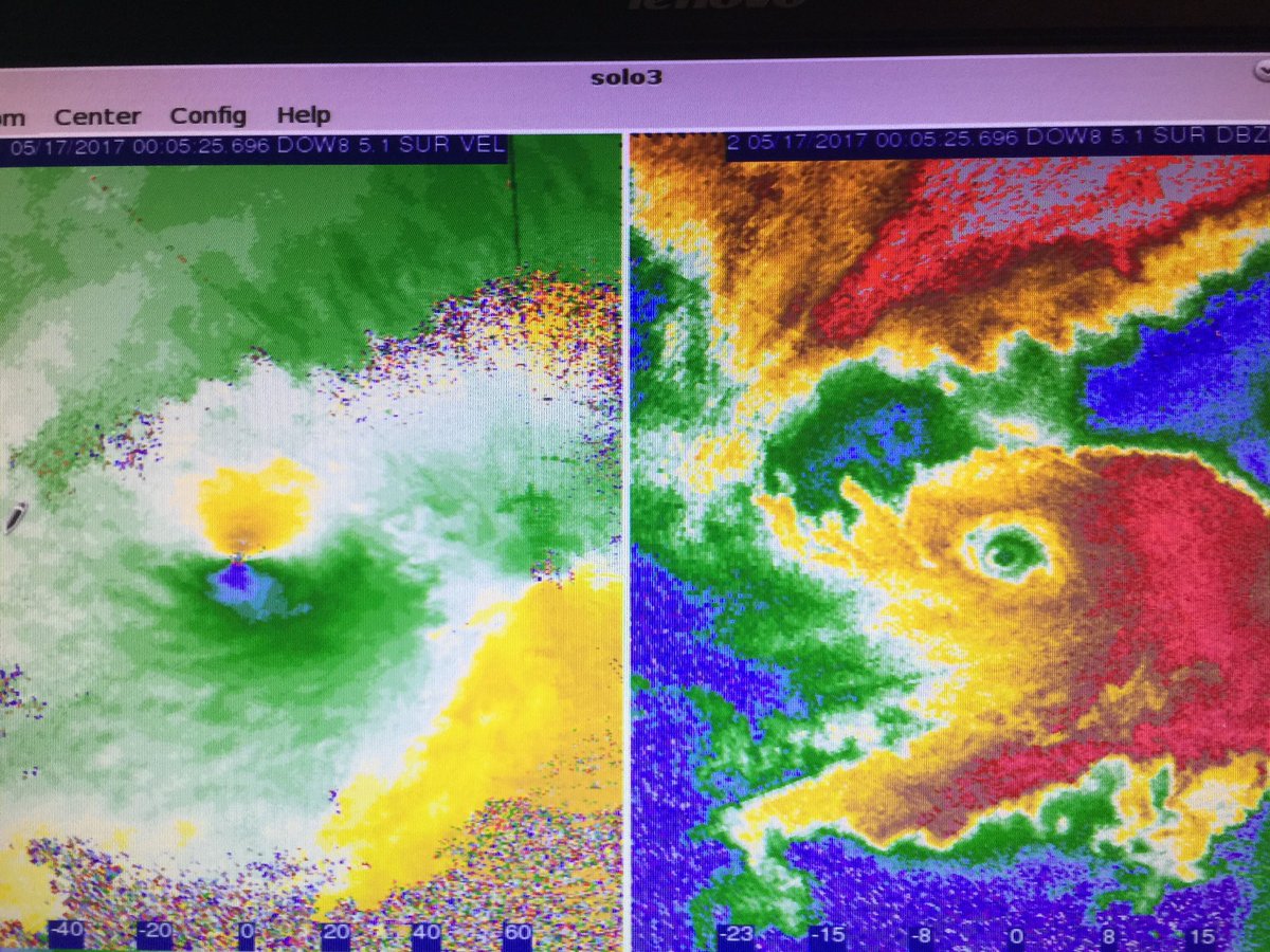
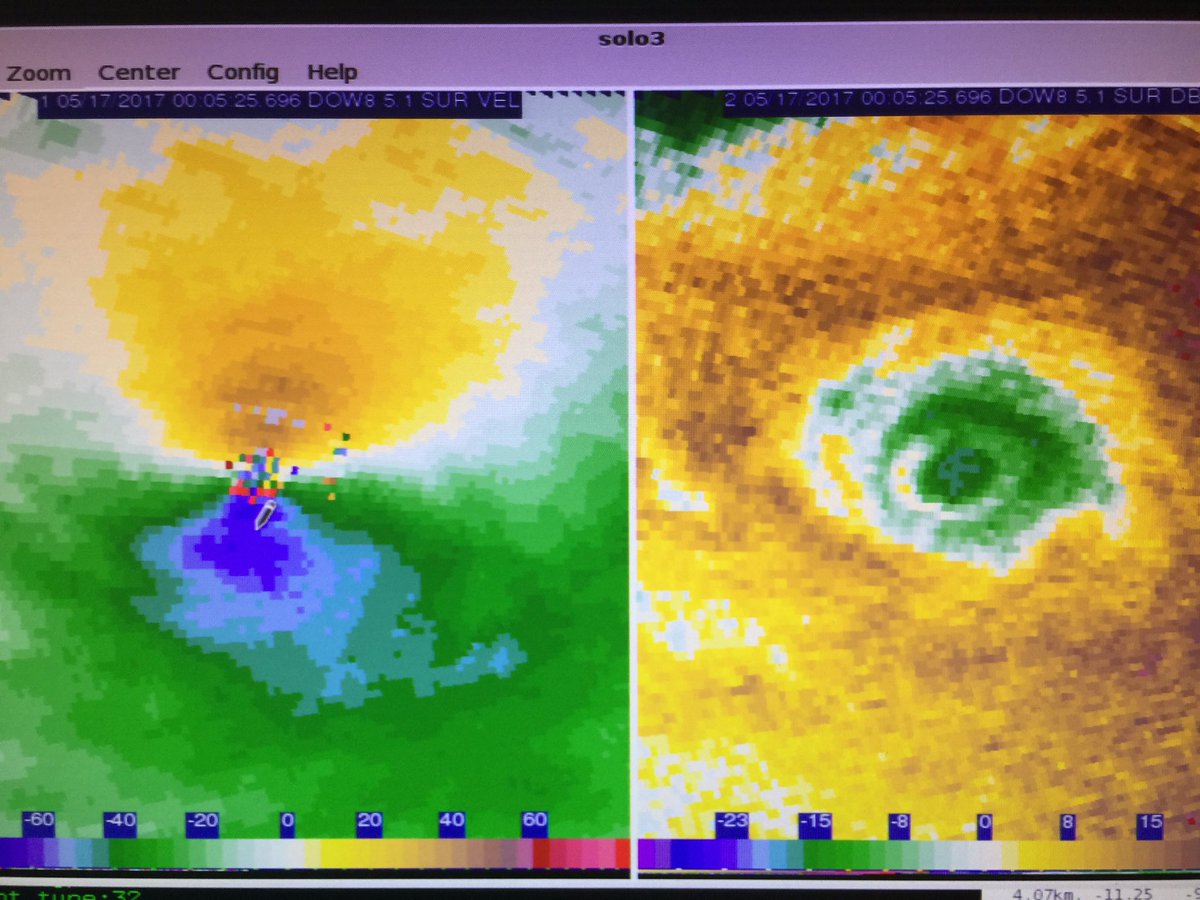
While we wait for something to happen here are some DOW images from the Elk City, OK tornado on Tuesday:

Posted on 5/18/17 at 8:30 am to rds dc
rds I was following that on TWC and they showed the new GOES satellite imagery and good lord being able to see the actual spin in these supercells is awesome!
Posted on 5/18/17 at 8:34 am to 50_Tiger
GOES 16 is one of the greatest additions to meterology and atmospheric science in the last 20 years.
Posted on 5/18/17 at 9:08 am to rds dc
Cape values today are ridiculous, I haven't seen hodographs like that in a while. And we have the elusive "Broyles" High risk.
Posted on 5/18/17 at 9:11 am to 50_Tiger
quote:
TWC and they showed the new GOES satellite imagery and good lord being able to see the actual spin in these supercells is awesome!
Tuesday resulted in some very interesting sat loops. The cells were spaced out just enough to see stuff like that. I'm pretty sure I know what cell you are taking about and will try to post a gif of it later.
Posted on 5/18/17 at 9:21 am to GEAUXmedic
quote:
Cape values today are ridiculous,
One of the reasons that there might be explosive upscale growth into clusters or line segments. If things stay even semi discrete then there could be big trouble.
Also, tomorrow and Saturday will likely make this a multiday outbreak.
Posted on 5/18/17 at 10:56 am to rds dc
This looks pretty messy, if storms fire like this then the tornado threat should be held in check. There would still be some but not on the higher end of what is possible given the parameter space.


Posted on 5/18/17 at 10:59 am to rds dc
Glad I don't live in NW OK
Posted on 5/18/17 at 11:49 am to okietiger
SPC upgrades the I35 corridor from DFW to OKC
Posted on 5/18/17 at 1:13 pm to rds dc
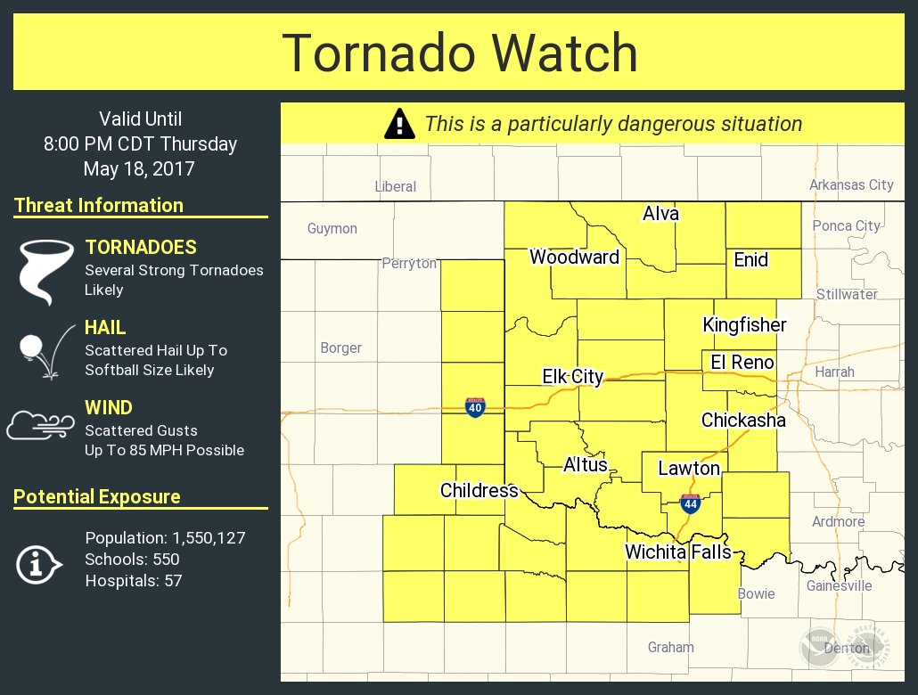
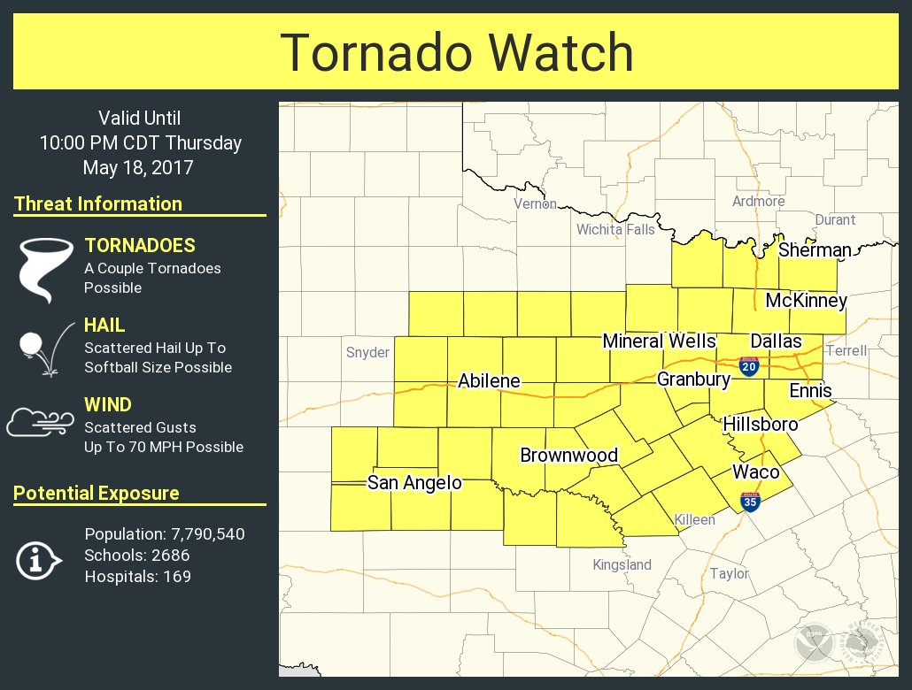
Tornado watch for North Texas coming and PDS Tornado watch for Western OK coming.


quote:
SUMMARY...Thunderstorms are expected to increase in coverage early
this afternoon across the southern Plains. Very large hail,
tornadoes, and damaging wind gusts will be possible. A tornado watch
will be needed within the next hour or so.
DISCUSSION...Visible satellite imagery depicts a developing cumulus
field across parts of Texas Rolling Plains this afternoon. With
ongoing surface heating and continued moistening of low levels,
convective inhibition has diminished considerably, as suggested by
surface observations, mesoanalysis, and forecast sounding data.
While not directly sampling the plume of greatest 850mb moisture
farther west, the 15Z OUN sounding sampled a deepening/moistening
boundary layer (as compared to the 12Z sounding). In turn, as broad
ascent associated with the western U.S. trough overspreads the
region, initiation of deep moist convection is expected early this
afternoon, with storms likely forming across the Texas Rolling
Plains along/east of the dry line. Indeed, two separate areas of
initiation are possible -- one within the broad warm sector near
subtle confluence/differential heating boundaries and another closer
to the dry line.
Regional 12Z soundings sampled very steep mid-level lapse rates (8-9
C/km) atop rich boundary-layer moisture spreading northward.
Continued heating of the boundary layer has promoted moderate/strong
buoyancy across the warm sector, with MLCAPE values upwards of
3000-4000 J/kg. In combination with sufficient effective shear
upwards of 40-45 kt, this thermodynamic environment will favor
strong/rotating mid-level updrafts, quite favorable for very large
hail in discrete cells and embedded cores. Additionally, some
veering with height of low-level winds and ample boundary-layer
moisture will encourage a tornadic threat, especially with
supercells that acquire a more eastward propagation component.
Damaging winds will also be a considerable threat, as dry mid-level
air favors ample evaporative cooling and strong downward momentum in
precipitation cores. Any upscale growth/cell mergers will further
enhance this threat. A tornado watch is expected within the next
hour or so.
quote:
SUMMARY...Severe thunderstorms will develop across portions of
western Oklahoma this afternoon. Tornadoes, a few of which may be
strong, very large hail, and damaging winds will be possible. A PDS
(Particularly Dangerous Situation) tornado watch will be issued
within the next hour.
DISCUSSION...As mid-level forcing for ascent gradually increases
this afternoon, thunderstorms will increase in coverage across much
of the region over the next 1-3 hours. Surface observations indicate
dew points have risen into the mid/upper 60s over much of the
discussion area. Wave/billow structures on visible satellite suggest
convective inhibition remains over parts of Oklahoma and Kansas this
afternoon, but continued boundary-layer heating/moistening and
cooling aloft are forecast to remove any remaining inhibition. In
turn, as the dry line focuses near the Oklahoma/Texas border,
thunderstorms will develop and likely become severe quite quickly.
Moreover, open warm sector development is also possible across
portions of southwest Oklahoma, within zones of confluence and
differential heating.
With the presence of moderate/strong buoyancy (around 2500-3500 J/kg
of MLCAPE) and effective shear upwards of 45-50 kt, initial
supercellular modes appear probable. Some forecast soundings
indicate a deep-layer wind profile marginally supportive of a few
left splits with initial warm sector development east of the dry
line this afternoon. Cell mergers/interference would preclude a
higher-end severe threat. However, as low-level hodographs enlargen
(with greater clockwise looping) late this afternoon into this
evening, cyclonically rotating supercells may become favored, with a
greater eastward component of movement. Any such discrete cell would
possess a threat for tornadoes (which could be strong), very large
hail, and damaging winds.
Farther west along the dry line, severe thunderstorms will likely
organize near the Oklahoma/Texas Panhandle border. Some potential
exists for northward-moving cells (from initial convection to the
south) to interfere with these cells, as well as cause convective
overturning, which would limit the severe threat some. However, the
genesis region of the southern cells, as well as their expected
motion, will likely keep them east of cells generating along the dry
line. In turn, a relatively pristine air mass should exist for
supercellular development by mid/late afternoon. Backed surface flow
and increasing boundary-layer moisture ahead of the dry line will
favor a threat of tornadoes, a few of which could be strong. Very
large hail and damaging winds will also be possible. A PDS
(Particularly Dangerous Situation) tornado watch will be issued
within the next hour.
Posted on 5/18/17 at 1:15 pm to Roll Tide Ravens
Seriously frick this state, drivers suck, weather sucks, topogrophy sucks, and the weather sucks. OK is not ok.
Posted on 5/18/17 at 1:17 pm to DoUrden
Boom
Posted on 5/18/17 at 1:26 pm to GEAUXmedic
And we have initialization:

Posted on 5/18/17 at 1:54 pm to Roll Tide Ravens
Here you go Dallas.

 Page 1 of 7

Popular
Back to top