- My Forums
- Tiger Rant
- LSU Recruiting
- SEC Rant
- Saints Talk
- Pelicans Talk
- More Sports Board
- Fantasy Sports
- Golf Board
- Soccer Board
- O-T Lounge
- Tech Board
- Home/Garden Board
- Outdoor Board
- Health/Fitness Board
- Movie/TV Board
- Book Board
- Music Board
- Political Talk
- Money Talk
- Fark Board
- Gaming Board
- Travel Board
- Food/Drink Board
- Ticket Exchange
- TD Help Board
Customize My Forums- View All Forums
- Show Left Links
- Topic Sort Options
- Trending Topics
- Recent Topics
- Active Topics
Started By
Message
re: Preliminary Ratings: Lacombe Tornado - EF1; NOLA/Arabi Tornado - EF3
Posted on 3/17/22 at 10:30 am to LegendInMyMind
Posted on 3/17/22 at 10:30 am to LegendInMyMind
quote:
Errr....Severe Thread BINGO?
At this point with the economy and what not you should be happy to know that at least something is being grown here in the US ...
 0
0

Posted on 3/17/22 at 11:22 am to Duke
quote:
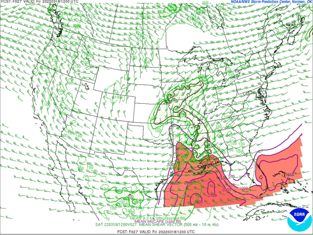
I keep going back and forth if there's enough to ENH SELA. Is slight+ a thing? HRRR doesnt quite destabilize the boundary layer for SELA, and thats really the question. Does the low level flow kill the marine layer and get us mixing at the surface?
I figure they'll keep it at Slight and just work off the MCDs throughout the night/morning for that area. The SE Alabama area may get the bump at the 1AM update.
Posted on 3/17/22 at 11:50 am to LegendInMyMind
SPC 11:30AM update:
Also, gonna be looking for some big spikes on radar in Oklahoma and North Texas this afternoon/evening.
quote:
SPC AC 171630
Day 1 Convective Outlook NWS Storm Prediction Center Norman OK 1130 AM CDT Thu Mar 17 2022
Valid 171630Z - 181200Z
...THERE IS A SLIGHT RISK OF SEVERE THUNDERSTORMS LATE THIS AFTERNOON INTO THIS EVENING OVER PARTS OF OKLAHOMA AND NORTH TEXAS...AND LATE TONIGHT IN PARTS OF LOUISIANA AND SOUTHERN MISSISSIPPI...
...SUMMARY... Threats for severe thunderstorms are expected late this afternoon into this evening over parts of Oklahoma and north Texas, and late tonight in parts of Louisiana and southern Mississippi. Large hail, damaging winds and a few tornadoes are possible.
...OK/TX this afternoon/evening... Upper-level trough will move east across the southern Plains through tonight, with cold mid-level temperatures shifting east in tandem with modestly increasing low-level moisture. This will result in a relatively narrow axis of MLCAPE of 1500 to locally 2000 J/kg developing in advance of a surface low and dryline. Thunderstorm development is anticipated during the late afternoon/early evening time frame as MLCIN diminishes and large-scale ascent increases with the approach of the upper trough. Deep-layer shear will support some risk for supercell storm structures, and very steep mid-level lapse rates and substantial CAPE in the hail growth region support a risk for significant severe hail in addition to damaging gusts. Enlarged low-level hodographs and lowering LCLs early this evening will support at least some risk for a tornado before the onset of nocturnal cooling. Overall, the previous outlook reasoning remains on track and have made no changes to the severe probabilities in this area.
...LA/MS overnight... Thunderstorm development is expected late tonight within an increasing warm/moist advection regime as the upper trough shifts east and the marine/warm front lifts north. Strong low-mid level wind fields will result in effective shear values sufficient for supercell storms with a risk for all severe hazards. An increase in tornado probabilities was considered with this outlook over portions of southwest MS and southeast/east-central LA for the potential for surface-based storms near the warm front, where a conditional risk for a significant tornado will exist. However, with concerns regarding a tendency for veering 850 mb flow during the 08-12z time frame have opted to maintain current categorical/probabilistic risk levels and shift tornado probabilities north across portions of southern MS/east-central LA. Additional adjustments to the risk in this area may be needed in later outlooks.
..Bunting/Dean.. 03/17/2022
CLICK TO GET WUUS01 PTSDY1 PRODUCT
NOTE: THE NEXT DAY 1 OUTLOOK IS SCHEDULED BY 2000Z
Also, gonna be looking for some big spikes on radar in Oklahoma and North Texas this afternoon/evening.

Posted on 3/17/22 at 11:53 am to LegendInMyMind
quote:
An increase in tornado probabilities was considered with this outlook over portions of southwest MS and southeast/east-central LA for the potential for surface-based storms near the warm front, where a conditional risk for a significant tornado will exist. However, with concerns regarding a tendency for veering 850 mb flow during the 08-12z time frame have opted to maintain current categorical/probabilistic risk levels and shift tornado probabilities north across portions of southern MS/east-central LA. Additional adjustments to the risk in this area may be needed in later outlooks.
So basically the threat will be further north as always. Deep South Louisiana is hurricane territory, not tornado alley.
Posted on 3/17/22 at 11:58 am to TDsngumbo
quote:
So basically the threat will be further north as always.
Thats not really what theyre saying. They expanded the 5% tor area north. The most important bit is the conditional risk of a strong tor in the region.
High winds and hail remain the most likely severe impacts. The conditional tornado risk is just something to be aware of since itll be overnight snd early morning.
Posted on 3/17/22 at 12:01 pm to Duke
Have I mentioned lately how much I love the wX app? So easy to get products.
This post was edited on 3/17/22 at 12:03 pm
Posted on 3/17/22 at 12:07 pm to Duke
Ah ok, guess I just read it wrong then because I read that as they’re saying they don’t see evidence of higher risk but they do see the risk area growing northward. We all know that means it’ll be focused up there instead of down here near Baton Rouge and New Orleans. That’s how it almost always is because of the marine layer.
Posted on 3/17/22 at 12:12 pm to TDsngumbo
quote:
We all know that means it’ll be focused up there instead of down here near Baton Rouge and New Orleans. That’s how it almost always is because of the marine layer.
No, the risk level stays the same in SE Louisiana, but that risk has been extended on the Northern side. The risk for SE Louisiana did not change except for the introduction of a possible upgrade in future updates.
Posted on 3/17/22 at 12:13 pm to TDsngumbo
They have questions about the winds at 850 that would lead to disrupting the rotation of the updrafts and slow the acceleration upward, and with the marginal thermo in the low levels that could be a failure mechanism for tors.
Enough that its hard to justify increasing the odds of tornadoes in the area but its worth noting tornadoes that do form in the region could be strong.
All that said, if Im targeting a region tonight, its along I12.
Enough that its hard to justify increasing the odds of tornadoes in the area but its worth noting tornadoes that do form in the region could be strong.
All that said, if Im targeting a region tonight, its along I12.
Posted on 3/17/22 at 12:26 pm to TDsngumbo
quote:
Meteorologist Nick Mikulas
Severe event number one should start to ramp up this evening. This one looks like it’ll be quite loud for most at the very least. Here’s how I think it’ll play out.
Thursday evening/night….
What do I mean by a “loud” threat tonight? These storms will be packed with moisture, and more importantly, loaded with a deep layer of ice/hail aloft. That’ll make for plenty of friction, which means loads of lightning. With ample (elevated) instability, which we discussed yesterday, and plenty of wind shear, these storms will be able to stay strong to severe for several hours, bringing a widespread threat of loudness/thunder, as well as a threat for some scattered hail. Given the set up, I wouldn’t be stunned to see a golfball sized hail report, but most of the hail should be in the pea to quarter sized range. Hail is still going to be a relatively isolated issue since the whole storm won’t just be a hail fest, but garage the cars tonight if possible. Another thing to note is that the warmer air, and surface based instability will be in place for areas like Baton Rouge, New Orleans, and Lafayette. This means an isolated tornado or two will be possible down that way. That could nudge as far north as parts of St. Landry Parish, so be on the lookout in that area. Up here, it seems like the storms will develop a few hours ahead of the surge in moisture, so hail is by far our main threat. I’ll never rule anything out, but the set up doesn’t favor tornadoes across most of Central Louisiana. There will be supercells, but the airmass should be just cool enough at the surface to keep the tornado threat to our southeast. I will watch this closely, but please obey all warnings. You can’t rationalize with a tornado warning and say, “well, Nick said these storms would likely be elevated.” I mean, you could try I guess.
Monday evening through Tuesday….
This is still looking like a potential severe weather outbreak over a two day period from Texas through Louisiana and Mississippi. That doesn’t mean two straight days of severe weather, though it looks like we could see a few severe storms in our area as soon as Monday night. The main threat for us comes on Tuesday, as the intense upper level feature kind of stretches out, and slowly pivots through. Some models indicate this slowing will allow training of strong to severe thunderstorms over several hours, but that’s a detail that won’t be clear until a day or two before this arrives. What is clear is that severe parameters are forecast to be quite favorable for at least one, and perhaps two rounds of severe weather in our area. Large hail, damaging wind, and tornadoes will all be possible in this event, as well as the potential for flooding rain. It’s impossible to get too detailed just yet, as timing will shift, but models have been consistent for several days regarding the strength of this system. The details we need to figure out depend on what the Monday storms do to our local atmosphere, and the timing of all of this. But it definitely looks like a bumpy ride for us, and many areas around us. I’ll be updating daily until this arrives, then I’ll be in constant update mode.


Posted on 3/17/22 at 12:47 pm to rt3
Its about that time of the year where shite gets WILD 
Posted on 3/17/22 at 1:36 pm to TDsngumbo
quote:
So basically the threat will be further north as always. Deep South Louisiana is hurricane territory, not tornado alley.
Michoud 2017


Posted on 3/17/22 at 2:05 pm to TD422
SPC expanded the slight risk for tomorrow to cover all of Alabama and added an enhanced risk in south Alabama and the western FL panhandle. 10% hatched tornado threat in the enhanced risk.


This post was edited on 3/17/22 at 2:06 pm
Posted on 3/17/22 at 2:08 pm to Roll Tide Ravens
The NOLA area is caught in that Day 1/Day 2 gap. Usually it is the Georgia folks in that position.
Posted on 3/17/22 at 2:14 pm to LegendInMyMind
Really leaning on the MS Paint down here this afternoon. 
Race against a napping baby that my slow arse internet is sure to make me lose.
Race against a napping baby that my slow arse internet is sure to make me lose.

Posted on 3/17/22 at 2:17 pm to LegendInMyMind
quote:
Deep-layer shear will support some risk for supercell storm structures,
Forgive my ignorance but what does this mean for my husband flying into DFW this evening?
Posted on 3/17/22 at 2:19 pm to 50_Tiger
quote:
Its about that time of the year where shite gets WILD
Playing tennis with these winds today was like watching baby deer on ice
Posted on 3/17/22 at 2:27 pm to LSUGrrrl
quote:
Forgive my ignorance but what does this mean for my husband flying into DFW this evening?
It means that he should let the airline worry about that and have faith that the pilots won't fly into a supercell storm.
Posted on 3/17/22 at 2:27 pm to LSUGrrrl
Shear is what organizes storms.
So with enough there, get a little lift and you get tilted and spinning updrafts which are what supercells are made of.
Big arse hail being the primary threat up your way.
So with enough there, get a little lift and you get tilted and spinning updrafts which are what supercells are made of.
Big arse hail being the primary threat up your way.
Posted on 3/17/22 at 2:28 pm to Duke
quote:
Really leaning on the MS Paint down here this afternoon.
This world would not be the same if not for MS Paint.

 Page 7 of 94

Popular
Back to top