- My Forums
- Tiger Rant
- LSU Recruiting
- SEC Rant
- Saints Talk
- Pelicans Talk
- More Sports Board
- Fantasy Sports
- Golf Board
- Soccer Board
- O-T Lounge
- Tech Board
- Home/Garden Board
- Outdoor Board
- Health/Fitness Board
- Movie/TV Board
- Book Board
- Music Board
- Political Talk
- Money Talk
- Fark Board
- Gaming Board
- Travel Board
- Food/Drink Board
- Ticket Exchange
- TD Help Board
Customize My Forums- View All Forums
- Show Left Links
- Topic Sort Options
- Trending Topics
- Recent Topics
- Active Topics
Started By
Message
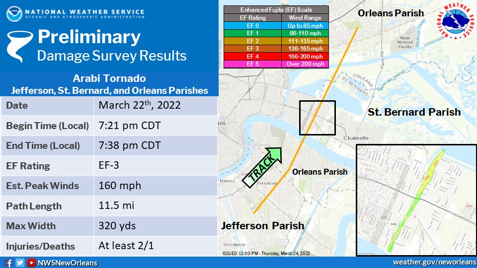
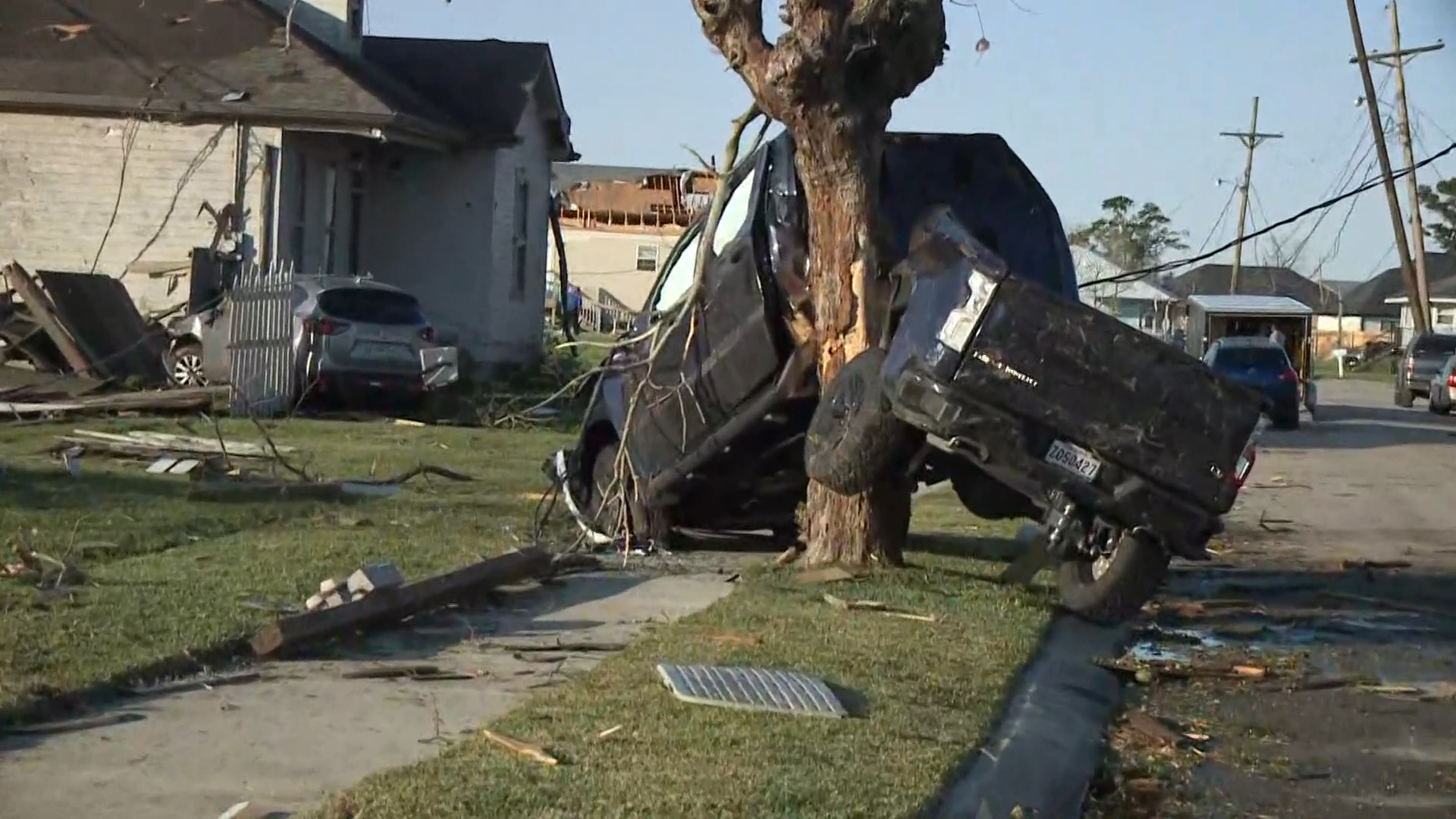
Preliminary Ratings: Lacombe Tornado - EF1; NOLA/Arabi Tornado - EF3
Posted on 3/15/22 at 12:09 pm
Posted on 3/15/22 at 12:09 pm
quote:
NWS New Orleans @NWSNewOrleans
[Corrected Graphic] Here is the latest track map on the EF-3 Arabi Tornado on March 22nd. There still may be more refinements to this track as we analyze more data.
More details can be found in our public information statement here: NWS Chat
#LAwx #tornado
quote:
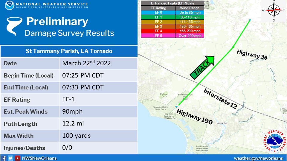
NWS New Orleans @NWSNewOrleans
Here is a graphic showing the track and details on the Lacombe, LA tornado that occurred between 7:25pm and 7:33pm last night. Survey showed damage indicating an EF1 rating with max winds of 90mph, a max width of 100 yards, and a path length of 12.2 miles. #lawx
NWS Chat
quote:
709
NOUS44 KLIX 231549
PNSLIX
LAZ034>037-039-046>050-056>061-063>072-075>078-MSZ068>071-077-
080>082-232000-
PUBLIC INFORMATION STATEMENT
NATIONAL WEATHER SERVICE NEW ORLEANS LA
1049 AM CDT WED MAR 23 2022
...NWS DAMAGE SURVEY FOR MARCH 22, 2022 TORNADO EVENT ...
.LACOMBE TORNADO...
RATING: EF1
ESTIMATED PEAK WIND: 90 MPH
PATH LENGTH /STATUTE/: 12.2 MILES
PATH WIDTH /MAXIMUM/: 100 YARDS
FATALITIES: 0
INJURIES: 0
START DATE: 03/22/2022
START TIME: 7:25 PM CDT
START LOCATION: 3.8 MILES WNW LACOMBE/ST. TAMMANY LA
START LAT/LON: 30.337/-90008
END DATE: 03/22/2022
END TIME: 7:33 PM CDT
END LOCATION: 11.85 NNE LACOMBE/ST.TAMMANY LA
END LAT/LON: 30.4782/-89.8802
SURVEY SUMMARY:
A TORNADO TOUCHED DOWN NEAR BIG BRANCH MARSH NATIONAL WILDLIFE
REFUGE ON HIGHWAY 190. DAMAGE BEGAN AT HOMES JUST NORTH OF 190,
INCLUDING MINOR ROOF DAMAGE, A SHED DESTROYED, AND DOZENS OF TREES
SNAPPED. TORNADO CONTINUED NE AND SIMILAR DAMAGE WAS NOTED ALONG
AZALEA ST AND CANE BAYOU LN. A TREE WAS UPROOTED ON THE CORNER OF
LOUND DR AND BLACKWELL DR. TORNADO CROSSED I-12 AND CONTINUED NE
TO FISH HATCHERY RD. RADAR SHOWED A TDS IN RURAL AREAS BETWEEN 190
AND FISH HATCHERY RD. TORNADO TRACK CONTINUED NE AND BEGAN TO
TRACK ALONG HIGHWAY 1088 JUST SW OF HIGHWAY 36. IN THIS AREA,
DOZENS OF TREES WERE DOWNED AND SNAPPED ALONG THE HIGHWAY. BASED
ON RADAR TDS THE TORNADO CONTINUED ANOTHER 3 MILES NORTH OF
HIGHWAY 36,IN RURAL AREAS. THE GENERAL TYPE OF DAMAGE SEEN
THROUGHOUT THE PATH OF THE TORNADO RANGED FROM STRONG EF0 TO WEAK
EF1, WITH A MAX WIND RATING OF 90MPH.
&&
EF SCALE: THE ENHANCED FUJITA SCALE CLASSIFIES TORNADOES INTO THE
FOLLOWING CATEGORIES:
EF0...WEAK......65 TO 85 MPH
EF1...WEAK......86 TO 110 MPH
EF2...STRONG....111 TO 135 MPH
EF3...STRONG....136 TO 165 MPH
EF4...VIOLENT...166 TO 200 MPH
EF5...VIOLENT...>200 MPH
NOTE:
THE INFORMATION IN THIS STATEMENT IS PRELIMINARY AND SUBJECT TO
CHANGE PENDING FINAL REVIEW OF THE EVENT AND PUBLICATION IN NWS
STORM DATA.
$$
HL/ME
preliminary EF-3 for NOLA/Arabi tornado
NWS Chat
quote:
038
NOUS44 KLIX 231557
PNSLIX
LAZ034>037-039-046>050-056>061-063>072-075>078-MSZ068>071-077-
080>082-232000-
PUBLIC INFORMATION STATEMENT
NATIONAL WEATHER SERVICE NEW ORLEANS LA
1057 AM CDT WED MAR 23 2022
...NWS METEOROLOGISTS CURRENTLY SURVEYING STORM DAMAGE NEAR ARABI
IN ST BERNARD PARISH LOUISIANA WITH AT LEAST EF-3 DAMAGE...
THE NATIONAL WEATHER SERVICE OFFICE IN NEW ORLEANS LA IS
CURRENTLY CONDUCTING A STORM SURVEY FOR THE AREA NEAR ARABI IN ST
BERNARD PARISH LOUISIANA. THE SURVEY IS IN RELATION TO THE SEVERE
THUNDERSTORMS THAT MOVED THROUGH THE AREA ON 03/22/2022. CURRENT
DAMAGE REVIEWED SHOWS AT LEAST EF-3 DAMAGE OCCURED LAST EVENING.
A FINAL ASSESSMENT INCLUDING RESULTS OF THE ENTIRE SURVEY ARE
EXPECTED TO BE COMPLETED AND TRANSMITTED VIA A PUBLIC INFORMATION
STATEMENT IN THE NEXT DAY OR TWO. WE THANK YOU FOR YOUR PATIENCE.
THE STORM SURVEY INFORMATION WILL ALSO BE AVAILABLE ON OUR
WEBSITE AT HTTP://WWW.WEATHER.GOV/LIX
$$
SCHOTT
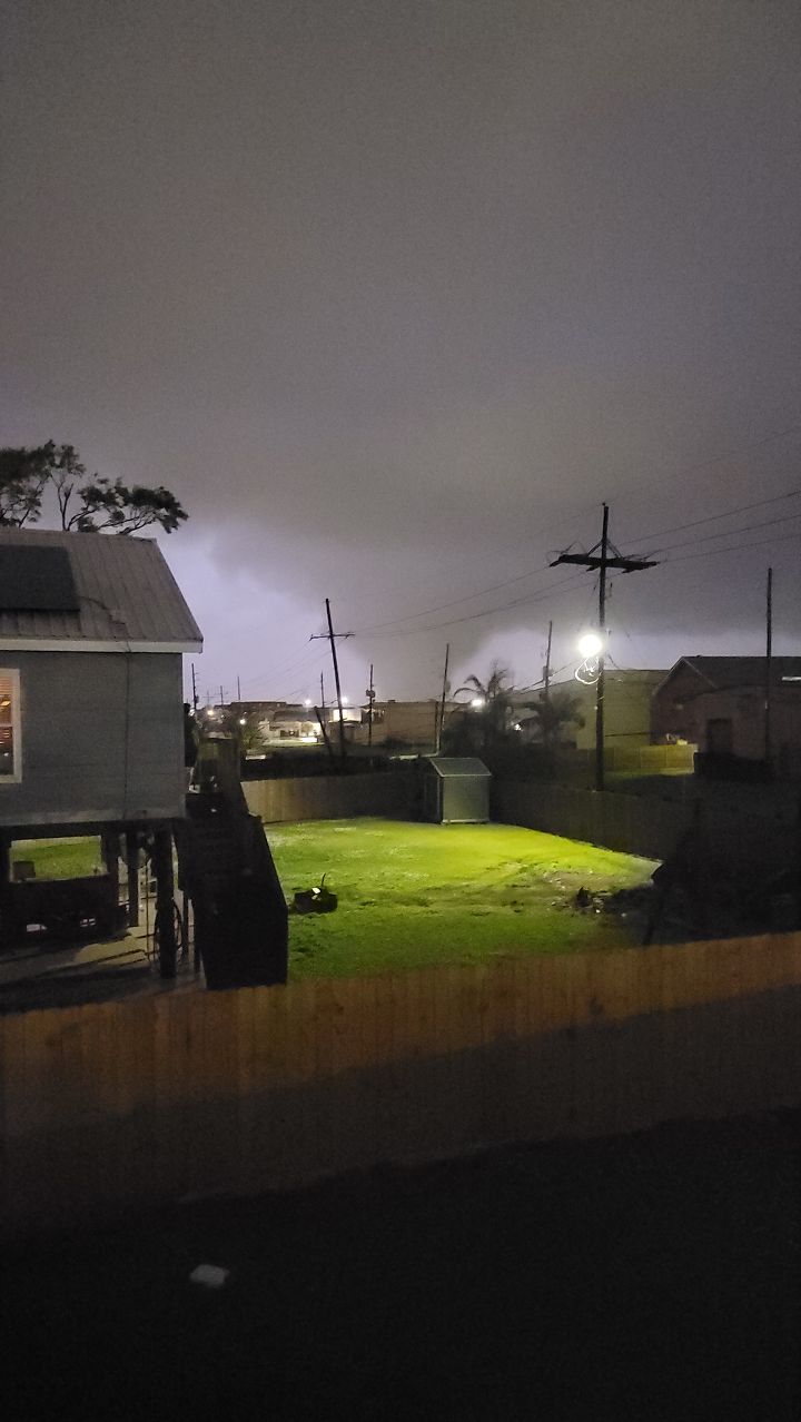
images from March 22nd NOLA tornado
quote:
FOX 8 New Orleans @FOX8NOLA
Tornado seen in Chalmette>> Fox8NOLA
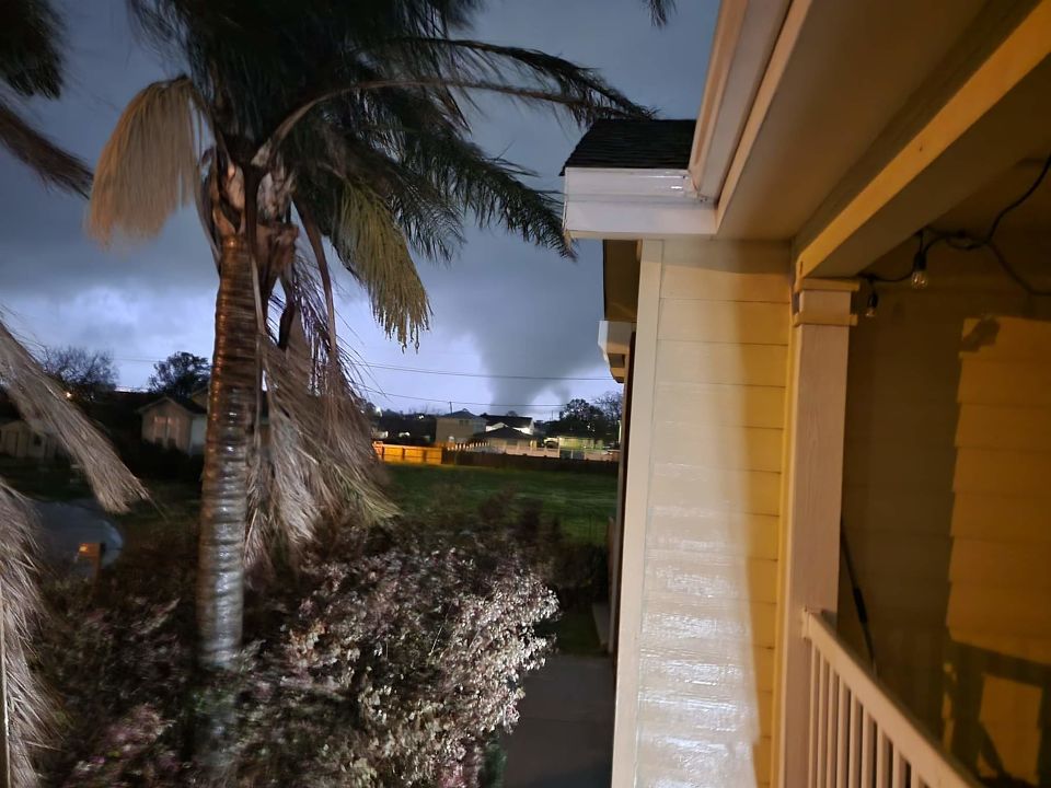
WWL-TV Twitter - Video of tornado rolling through Arabi
quote:
WWL-TV @WWLTV
Devastation in Arabi, La.


This post was edited on 3/24/22 at 2:06 pm
 40
40


Posted on 3/15/22 at 12:11 pm to rt3
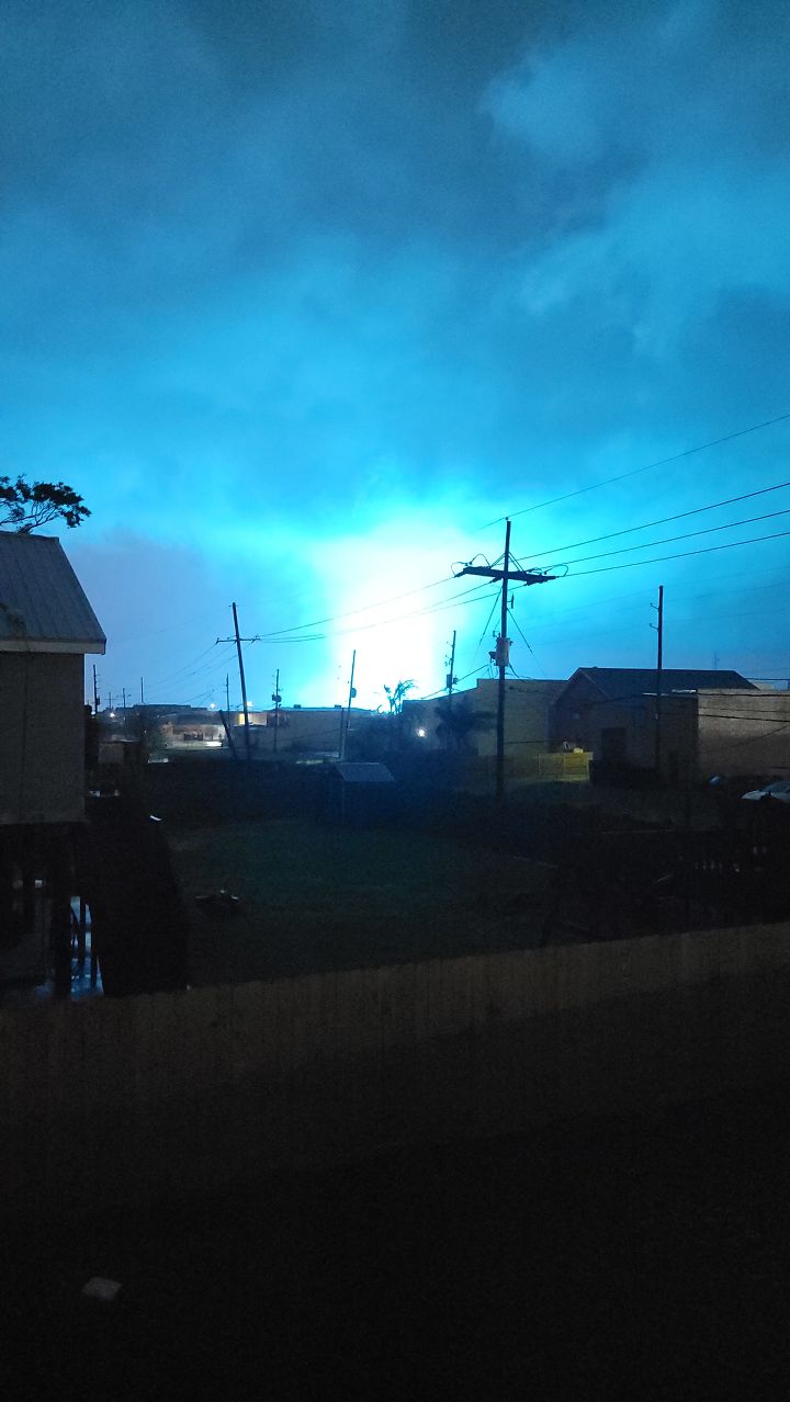
Saw the brightest lightning I've ever seen on my way to work this morning.
Posted on 3/15/22 at 12:12 pm to Bestbank Tiger
quote:
Saw the brightest lightning I've ever seen on my way to work this morning.
it's all bright

Posted on 3/15/22 at 12:12 pm to rt3
We love the rainy season don't we folks. My poor dog crawled under the bed last night, that thunder and lightning was wild.
Posted on 3/15/22 at 12:19 pm to rt3
Ensembles are all hitting on the same idea, but some spread in how the operational models are evolving things.
I want to get a little closer before really diving into details but I agree with Nick, this is the first system this spring with some outbreak potential.
I want to get a little closer before really diving into details but I agree with Nick, this is the first system this spring with some outbreak potential.

Posted on 3/15/22 at 12:19 pm to rt3
Never a good feeling when a threat starts getting mentioned a week out. Usually the moderate and high risk days start out being mentioned a week or so out.
Not saying this will end up being a moderate or high risk event, though.
Not saying this will end up being a moderate or high risk event, though.
Posted on 3/15/22 at 12:20 pm to rt3
As long as it doesn't hit at 4am and wake me up I don't care
Posted on 3/15/22 at 12:21 pm to Duke
quote:
Ensembles are all hitting on the same idea, but some spread in how the operational models are evolving things.
I want to get a little closer before really diving into details but I agree with Nick, this is the first system this spring with some outbreak potential.
since you're now in this thread Duke...
Nick says it in his post... and I recognize it as well... SPC hardly ever has severe probabilities out 6-7-8 days out
it is very uncommon, no?
I fear that as we get closer... those probabilities will only go up and up
Posted on 3/15/22 at 12:22 pm to rt3
Looks like I’ll need to fertilize my yard early next week.

Posted on 3/15/22 at 12:25 pm to rt3
It hailed not once, but twice in Central Dallas yesterday afternoon. We almost never get hail in the city
Posted on 3/15/22 at 12:25 pm to ElderTiger

Posted on 3/15/22 at 12:27 pm to Klark Kent
Gonna fertilize mine before the friday rain I think
Posted on 3/15/22 at 12:32 pm to rt3
quote:
it is very uncommon, no?
It is unusual but cut a strong upper low across the southern half of the country in late March and you expect trouble.
I still have questions for Wednesday if the instability and shear are going to line up right but thats more a question of degree of the threat vs severe/not severe.
Posted on 3/15/22 at 12:56 pm to Duke
quote:
It is unusual but cut a strong upper low across the southern half of the country in late March and you expect trouble.
right... they must be feeling something to put the probabilities out already... even with...
quote:
I still have questions for Wednesday if the instability and shear are going to line up right but thats more a question of degree of the threat vs severe/not severe.
Posted on 3/15/22 at 12:57 pm to rt3
quote:
SPC already targeting next Tuesday/Wednesday for potential Deep South severe threat
Tis the season. Buckle up.
Posted on 3/15/22 at 1:02 pm to rt3
quote:
it is very uncommon, no?
They do, but not often.
I want to say they did it for one of the setups in March of last year. That would have been the one that got me a little tiffed because Spann and his crew decided to put out their own Categorical Outlook on day 4 or 5 using the same colors, graphics, and terminology as the SPC.
SPC doesn't issue a Categorical Outlook beyond Day 3. They just don't. Piggybacking on their graphics and terminology to issue your own as a local, on air met only gums up the works, whether you're James Spann or not.

Posted on 3/15/22 at 1:05 pm to rt3
I feel like we get the "it's super rare to have threats tagged a week out..." 2-3x a year now.
That said, they usually materialize when it happens. So perhaps they're just getting consistently better at it and it's not as rare anymore.
That said, they usually materialize when it happens. So perhaps they're just getting consistently better at it and it's not as rare anymore.

Posted on 3/15/22 at 1:05 pm to LegendInMyMind
Call me weird but the thought of drinking a beer on my back patio in the evening as a thunderstorm rolls thru just sounds lovely and relaxing.
Posted on 3/15/22 at 1:10 pm to jcaz
Hell, that's normal as far as I'm concerned.
Posted on 3/15/22 at 1:22 pm to Bestbank Tiger
quote:
Saw the brightest lightning I've ever seen on my way to work this morning.
I thought the same thing when it happened.

 Page 1 of 94

Popular
Back to top