- My Forums
- Tiger Rant
- LSU Recruiting
- SEC Rant
- Saints Talk
- Pelicans Talk
- More Sports Board
- Fantasy Sports
- Golf Board
- Soccer Board
- O-T Lounge
- Tech Board
- Home/Garden Board
- Outdoor Board
- Health/Fitness Board
- Movie/TV Board
- Book Board
- Music Board
- Political Talk
- Money Talk
- Fark Board
- Gaming Board
- Travel Board
- Food/Drink Board
- Ticket Exchange
- TD Help Board
Customize My Forums- View All Forums
- Show Left Links
- Topic Sort Options
- Trending Topics
- Recent Topics
- Active Topics
Started By
Message

 5
5

Posted on 9/1/16 at 9:17 pm to rds dc
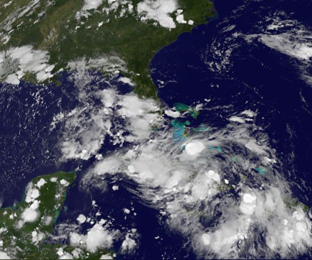
And it could end up being a long night in Tampa as that feeder ban rotates through:

and possibly during the morning hours:

and possibly during the morning hours:
This post was edited on 9/1/16 at 9:20 pm
Posted on 9/1/16 at 9:22 pm to rds dc
Yeah rdc. The low-level vorticity was always strong since when 99L was out in the mid-Atlantic. It was the dry air and shear that held it down. It was a matter of if and when the shear would relax and the dry air would be replaced. Fortunately, things did not come together soon enough for Hermine to become a monster, but she is still going to be a problem for many areas.
Posted on 9/1/16 at 9:32 pm to rds dc
I'd love to see the second picture like the first one.

Posted on 9/1/16 at 9:41 pm to rds dc
Any interesting live feeds come up?
Posted on 9/1/16 at 9:55 pm to nastynelly
Posted on 9/1/16 at 10:04 pm to rds dc
I've been sick and not following much. Anything behind this one??

Posted on 9/1/16 at 10:14 pm to tiger91
Another disturbance is out in Atlantic with 20% chance of developing in next 5 days.

Posted on 9/1/16 at 10:22 pm to ForeverLSU02
Official landfall yet?
Posted on 9/1/16 at 10:23 pm to NorthEndZone
Posted on 9/1/16 at 10:24 pm to NorthEndZone
i havent followed this at all.
is Cape San Blas, FL going to get hit pretty hard or what? if so, when.
TIA
is Cape San Blas, FL going to get hit pretty hard or what? if so, when.
TIA
Posted on 9/1/16 at 10:26 pm to Lester Earl
quote:
Cape San Blas, FL
Looks like they've been getting the Western Side of the Eyewall...which is pretty well together and intact right now
LINK
10:00 central update, max sustain winds 80
This post was edited on 9/1/16 at 10:29 pm
Posted on 9/1/16 at 10:33 pm to deuce985
Gulf Coast Weather is saying that the eastern eyewall has wind gusts over 100mph.

Posted on 9/1/16 at 10:56 pm to WylieTiger
I believe it. Using the velocity product on RadarScope with the inspection tool I can find readings up in mid to upper 90 mph's. I found some 105+ when the eye wall was still offshore. Of course, that is all radar indicated, so I wouldn't be surprised for their to be some higher gusts.
Posted on 9/1/16 at 11:33 pm to Roll Tide Ravens
For the most part I think we all lucked out

Posted on 9/2/16 at 3:35 am to rds dc
quote:Because of potential tornadoes?
And it could end up being a long night in Tampa as that feeder ban rotates through:
Any idea about the wind in the Tampa/St. Pete area? I'm seeing between 10-30 mph...but there ain't no way. Nothing TOO bad, but it sounds pretty gnarly outside.
This post was edited on 9/2/16 at 3:36 am

Posted on 9/2/16 at 3:38 am to ReauxlTide222
We're all hands on deck up in Virginia tomorrow. Bad risk of flooding.
Posted on 9/2/16 at 4:02 am to pankReb
Posted on 9/2/16 at 5:12 am to themunch
Just downgraded to tropical storm

 Page 172 of 175

Popular
Back to top