- My Forums
- Tiger Rant
- LSU Recruiting
- SEC Rant
- Saints Talk
- Pelicans Talk
- More Sports Board
- Fantasy Sports
- Golf Board
- Soccer Board
- O-T Lounge
- Tech Board
- Home/Garden Board
- Outdoor Board
- Health/Fitness Board
- Movie/TV Board
- Book Board
- Music Board
- Political Talk
- Money Talk
- Fark Board
- Gaming Board
- Travel Board
- Food/Drink Board
- Ticket Exchange
- TD Help Board
Customize My Forums- View All Forums
- Show Left Links
- Topic Sort Options
- Trending Topics
- Recent Topics
- Active Topics
Started By
Message
re: Preliminary Ratings: Lacombe Tornado - EF1; NOLA/Arabi Tornado - EF3
Posted on 3/21/22 at 3:50 pm to Roll Tide Ravens

Posted on 3/21/22 at 3:50 pm to Roll Tide Ravens
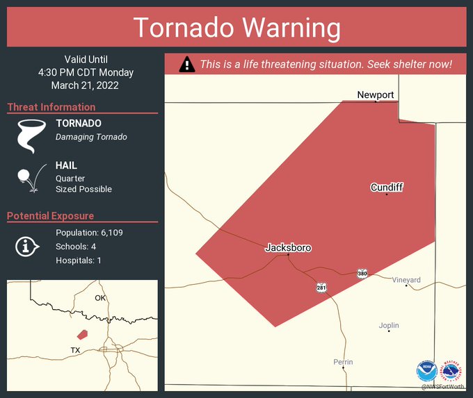
TDS on the storm approaching Jacksboro, TX.
 2
2

Posted on 3/21/22 at 3:51 pm to Roll Tide Ravens
Interesting polygon. They made sure to go ahead and include that little tail on the South end of the storm in case a secondary rotation forms.
Posted on 3/21/22 at 3:53 pm to Roll Tide Ravens
quote:
TDS on the storm approaching Jacksboro, TX.
It had a stouter one a few frames ago, but yea, it is still there.
Posted on 3/21/22 at 3:54 pm to purple18
EBR Parish public schools will dismiss early on Tuesday. All high schools and middle schools will dismiss at 11:45 a.m.; elementary schools will dismiss at 12:45 p.m.

Posted on 3/21/22 at 3:54 pm to LegendInMyMind
That's probably a pretty nasty tornado. Got some velocity folding
Posted on 3/21/22 at 3:57 pm to LegendInMyMind
Poured my first jack and coke and opened up GR2. Gonna be a wild one.

Posted on 3/21/22 at 3:58 pm to Roll Tide Ravens
Any chance these hefty storms take some juice out the atmosphere before the next round?
Posted on 3/21/22 at 4:02 pm to Roll Tide Ravens
PDS Warning on the Jackboro storm
Posted on 3/21/22 at 4:08 pm to LegendInMyMind
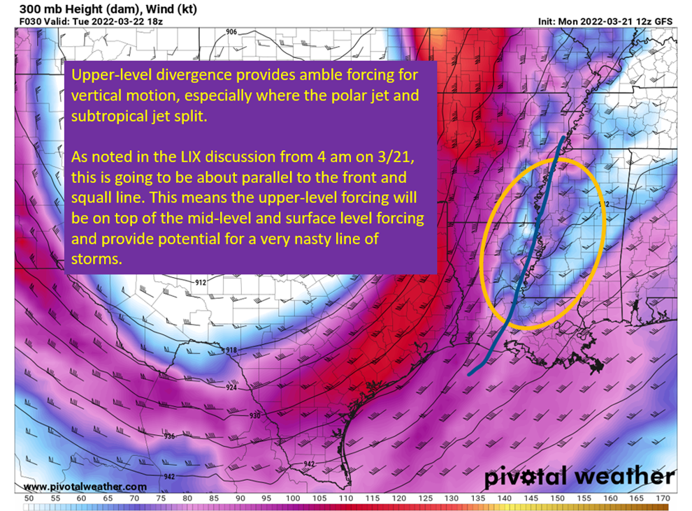
Context on the risk tomorrow
Now, to join The Boat with some GR2 and a beer to watch Texas print supercells.
quote:
The threat of discrete supercells is the threat that would maximize the parameters and produce large tornadoes and hail. It is not a certainty those will fire, but if they do, they really have very high end potential. The most likely locations for those cells would be along and north of US 190 and I12 and really maturing as they enter Mississippi. Some convective allowing models show those cells forming farther east into western Alabama, and they would provide the same high end threat over there if they do. This is not to say areas south of US 190 won’t have these dangerous prefrontal storms, just that the areas north look far more likely.
Follow that threat will be a strong line of storms that will present a damaging straight line wind, embedded tornado, and hail threat. Once again, the most likely locations for that will be in the moderate risk zone of the SPC chart shown near the top of the post but anywhere in the risk region could see those threats materialize from this line. So stay weather aware tomorrow, have a plan if a tornado threatens your area, and have multiple ways to receive warnings.
Now, to join The Boat with some GR2 and a beer to watch Texas print supercells.

Posted on 3/21/22 at 4:12 pm to Duke
quote:
Also, my concern is growing for the Metroplex into the evening in terms of tornadoes.
Come on, Duke. We’ve already talked about this. We decided on south, dammit!
Posted on 3/21/22 at 4:15 pm to LSUGrrrl
I dont make the rules, the atmosphere does. South of you still has the best parameters but you're gonna be close to the low and the warm front which will lead to extra low level shear.
Just a concern I have watching things evolve so far this afternoon.
Just a concern I have watching things evolve so far this afternoon.
Posted on 3/21/22 at 4:16 pm to TigerstuckinMS
quote:
Apple. Sized. Hail.
I-phone, or tablet sized?
Posted on 3/21/22 at 4:16 pm to LSUGrrrl
We had a healthy line but nothing warned as it rolls east and northeast
Posted on 3/21/22 at 4:16 pm to Duke
Pretty sexy divergence. You can really see her legs spread.
Posted on 3/21/22 at 4:18 pm to LSUGrrrl
All Schools in Acadiana area closed tomorrow.
Posted on 3/21/22 at 4:20 pm to The Boat
quote:
You can really see her legs spread
Gonna lead to some below the belt vertical motion.
Posted on 3/21/22 at 4:20 pm to The Boat
quote:
opened up GR2.
I'm not jelly....you are.
Posted on 3/21/22 at 4:21 pm to Duke
Airtag to iPhone se size baw.
Posted on 3/21/22 at 4:21 pm to Duke
quote:
Gonna lead to some below the belt vertical motion.
really makes you want to twist your nipples in a counter clockwise fashion.
Posted on 3/21/22 at 4:21 pm to tarzana
I-phone, or tablet sized?
If it was only that simple, they have too many sizes between the two.
If it was only that simple, they have too many sizes between the two.

 Page 23 of 94

Popular
Back to top