- My Forums
- Tiger Rant
- LSU Recruiting
- SEC Rant
- Saints Talk
- Pelicans Talk
- More Sports Board
- Fantasy Sports
- Golf Board
- Soccer Board
- O-T Lounge
- Tech Board
- Home/Garden Board
- Outdoor Board
- Health/Fitness Board
- Movie/TV Board
- Book Board
- Music Board
- Political Talk
- Money Talk
- Fark Board
- Gaming Board
- Travel Board
- Food/Drink Board
- Ticket Exchange
- TD Help Board
Customize My Forums- View All Forums
- Show Left Links
- Topic Sort Options
- Trending Topics
- Recent Topics
- Active Topics
Started By
Message

 1
1

Posted on 4/24/17 at 5:15 pm to Roll Tide Ravens
quote:
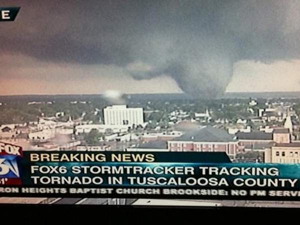
There is something about these dates and tornado outbreaks. Obviously one particular outbreak in this date period takes the cake.
not to bring up bad memories... but since you brought it up
Posted on 4/24/17 at 5:16 pm to tigerinthebueche
quote:
WTH should I believe you can possibly predict 7 days from today? you people can't forecast tomorrow unless a high pressure system moves in today. Then, at best, you're half right on your predictions.
These are not predictions, these are simply outlooks. They are just a thought of where we may have severe weather in the next several days. They are points of discussion. They aren't predictions and everyone who actually knows anything about weather forecasting knows that these things can absolutely change.
Posted on 4/24/17 at 5:17 pm to rds dc
Day 5 is interesting to me
I work in intercollegiate athletics in Alexandria and we have a pretty big baseball series here on Fri.-Sat.
maybe we should be thinking of moving the schedule around
ETA: I don't understand the downvote... these forecasts are of major importance to me both personally and professionally
I work in intercollegiate athletics in Alexandria and we have a pretty big baseball series here on Fri.-Sat.
maybe we should be thinking of moving the schedule around
ETA: I don't understand the downvote... these forecasts are of major importance to me both personally and professionally
This post was edited on 4/24/17 at 10:40 pm
Posted on 4/24/17 at 10:06 pm to baytiger
quote:
first time I've seen Ventrice's severe index pop up outside of work
Here is what it ginned up for Sunday...
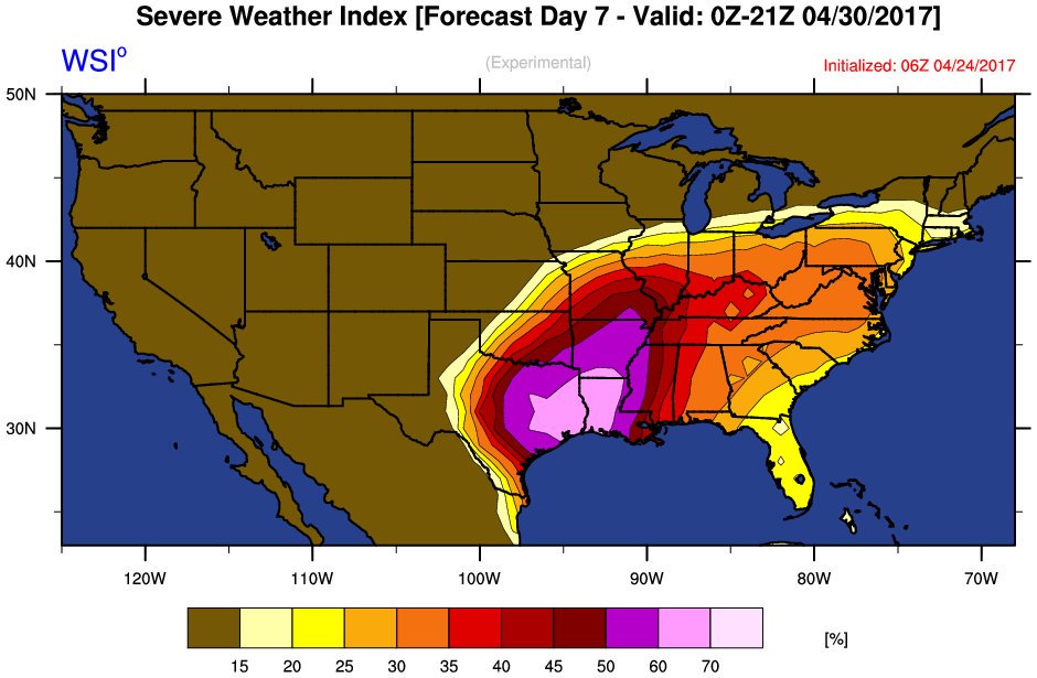
It seems to do ok and I would be interested in seeing him do a paper on it. There is an experimental tornado forecast based off of GEFS reforecast and analogs that often shows similar results to the WSI one. However, the WSI is svr wx and the GEFS reforecast is for tornadoes. Here is what it shows for the upcoming period:

Basically, anything that can time up RWP in MAM is going to show some skill in predicting svr wx. Then going a step out beyond those, work focused on the MJO and GWO/AAM also show some promise but the models still struggle with both of those in the longer range.

Posted on 4/25/17 at 10:33 am to rds dc
quote:
It seems to do ok and I would be interested in seeing him do a paper on it.
He's standing right behind me. I'll show him this thread
Posted on 4/25/17 at 10:56 am to baytiger
He got a good laugh out of it... apparently it's something that he hasn't spent a whole lot of time on in the last year and hasn't done any kind of comprehensive study with. I've used it to forecast convection in Asia to some success but haven't verified it against actual severe weather, only incidences of aviation-relevant convection.

Posted on 4/25/17 at 10:57 am to rds dc
Great.
Posted on 4/25/17 at 12:42 pm to okietiger
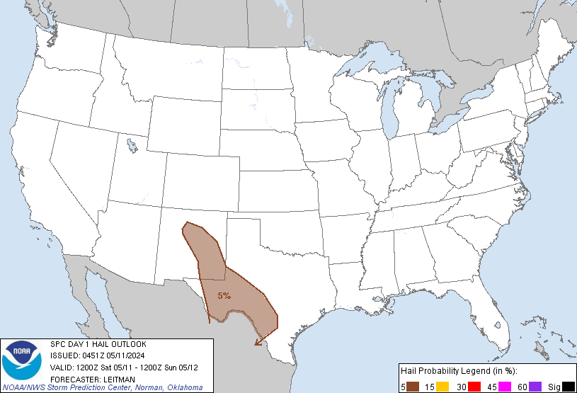
New outlook for today is Enhanced risk for Oklahoma today, primarily for hail, then an enhnced risk tomorrow for Arkansas. Day 4 and 5 have been given a 30% chance for severe thunderstorms for Arkansas and Oklahoma for Day 4 and Northern Louisiana and Eastern Texas for Day 5. I'll let the real experts chime in for what kind of mode of ever weather.

Posted on 4/25/17 at 1:15 pm to lsuman25
we spent alot of time looking at the outlook for north louisiana for tomorrow in class today. looks like theres gonna be a pretty decent cap in place but if its able to get erroded away shite could get serious in a hurry. looks like the heaviest risk for severe will be in south central arkansas.
Posted on 4/25/17 at 1:16 pm to rds dc
Why did I move to OK. 
Posted on 4/25/17 at 1:16 pm to baytiger
quote:where you work bay?
first time I've seen Ventrice's severe index pop up outside of work
Posted on 4/25/17 at 1:42 pm to Pedro
I mean I pretty much answered that in this thread 
Posted on 4/25/17 at 1:56 pm to rds dc
Models are having a hard time with anything this year. NAM and GFS have totally different scenarios for Oklahoma on Friday.
Posted on 4/25/17 at 2:06 pm to baytiger
True I'm just dumb. Hahaha.
Went in a computer lab on campus after posting that and one of my friends had his twitter up looking at those charts.
Went in a computer lab on campus after posting that and one of my friends had his twitter up looking at those charts.
Posted on 4/26/17 at 1:10 am to Pedro
Moderate Risk today for North Louisiana, Southern Arkansas. 15% hatched tornado risk for that area.
Posted on 4/26/17 at 1:26 am to lsuman25
Looking at the GFS and NAM it appears the threat moves south and east in the evening/overnight hours.
Posted on 4/26/17 at 1:28 am to lsuman25
quote:
Moderate Risk today for North Louisiana, Southern Arkansas. 15% hatched tornado risk for that area.


quote:
...SUMMARY...
Severe thunderstorms are expected across the Lower Mississippi
Valley Wednesday. Tornadoes, large hail, and damaging winds should
focus from northeast Texas across southern Arkansas and northern
Louisiana primarily during the afternoon hours. Isolated severe
thunderstorms may extend as far north as Illinois and into the
central Gulf States during the overnight hours.
...Lower MS Valley...
Early-morning water vapor/radar imagery depict a well defined upper
circulation over northeast NM shifting east-southeast in line with
late-evening model guidance. High-level flow is increasing across
the southern Rockies and 500mb speeds on the order of 75kt will
translate into central TX later today. This feature will induce
significant mid-level height falls across the lower MS Valley and
encourage strengthening LLJ over LA/AR by 18z.
26/00z observed soundings across TX depict very steep mid-level
lapse rates, on the order of 8.5-9 c/km, and this lapse-rate plume
should spread across the Arklatex region prior to convective
development. Current thinking is thunderstorms will struggle to
develop across much of TX due to significant CINH and this should
allow air mass to destabilize across the MDT risk region as surface
temperatures warm to near 80F with near 70F dew points. Forecast
NAM soundings by early afternoon depict SBCAPE in excess of 3000
J/kg across northeast TX where convection should initiate prior to
frontal passage. Shear profiles strongly favor supercells, though
mid-level height falls and slightly backed mid-level flow could
eventually lead to a more complex MCS as the trough ejects toward
the Mid-south after dark. Very large hail could accompany the
supercells across the Arklatex region and tornadoes appear possible.
Strong/severe convection should spread into the central Gulf States
during the evening/overnight hours as entrance region of upper jet
shifts into this region during the latter half of the period.
Posted on 4/26/17 at 6:03 am to GEAUXmedic
First watch of the day.
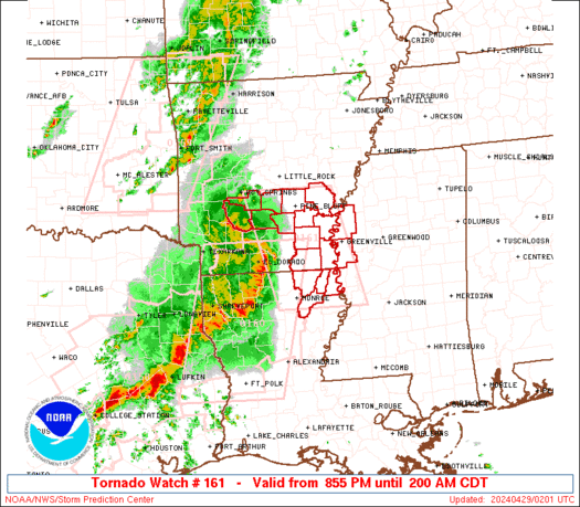
Posted on 4/26/17 at 6:04 am to GEAUXmedic
Looks like we have round 2 Saturday/Sunday


 Page 2 of 17

Popular
Back to top