- My Forums
- Tiger Rant
- LSU Recruiting
- SEC Rant
- Saints Talk
- Pelicans Talk
- More Sports Board
- Fantasy Sports
- Golf Board
- Soccer Board
- O-T Lounge
- Tech Board
- Home/Garden Board
- Outdoor Board
- Health/Fitness Board
- Movie/TV Board
- Book Board
- Music Board
- Political Talk
- Money Talk
- Fark Board
- Gaming Board
- Travel Board
- Food/Drink Board
- Ticket Exchange
- TD Help Board
Customize My Forums- View All Forums
- Show Left Links
- Topic Sort Options
- Trending Topics
- Recent Topics
- Active Topics
Started By
Message
re: Tornado! Threat Clearing Louisiana
Posted on 4/28/17 at 11:02 pm to beebefootballfan
Posted on 4/28/17 at 11:02 pm to beebefootballfan
quote:
Here is your reason for the bust. Same thing has happened all week.
The cap is just a symptom of the problem (probably not the best wording) that caused the bust. The actual reason was that the timing was off with the pieces of energy rotating around the base of the trough and that the trough was slower and deeper than what the models were showing earlier in the week. That allowed a prolonged period of SW flow off the high terrain of Mexico that transported warm dry air out in front of the system, that is the cap. Even so, with a much stronger cap in place than expected, the 00z FWD sounding showed that the cap had basically been eroded but there was not trigger for convective initiation since the next piece of energy hasn't kicked out across the warm sector. Timing is everything. Also, the slower deeper trough ejection will produce wind profiles tomorrow that are more supportive of a major squall line than discrete tornadic supercells.
 1
1

Posted on 4/28/17 at 11:15 pm to rds dc
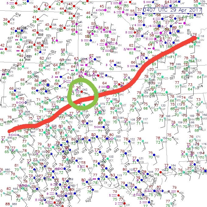
Tonight is the perfect example of a highly conditional setup producing a tornado, kind of like the tornado that unexpectedly hit New Orleans a while back. Overall, things don't appear very supportive of tornadoes outside of the area right along the warm front (red line) and that is where the tornadic cell is. If it rides the warm front, then the threat will continue, if it moves off the front then the threat will diminish.
Posted on 4/28/17 at 11:22 pm to rds dc
There was a confirmed tornado with that cell about 25 min ago.
Posted on 4/29/17 at 1:00 am to beebefootballfan
There is a cell in northern Washington County just north of the warm front trying to rotate. Huge hail in it. Strong inflow. Low level rotation isn't quite sufficient enough yet.
Posted on 4/29/17 at 3:17 pm to razorbackfan4life
Tornado warned cell heading toward I-20 between Rusto and Monroe
Posted on 4/29/17 at 3:21 pm to ptra
quote:
ornado warned cell heading toward I-20 between Rusto and Monroe
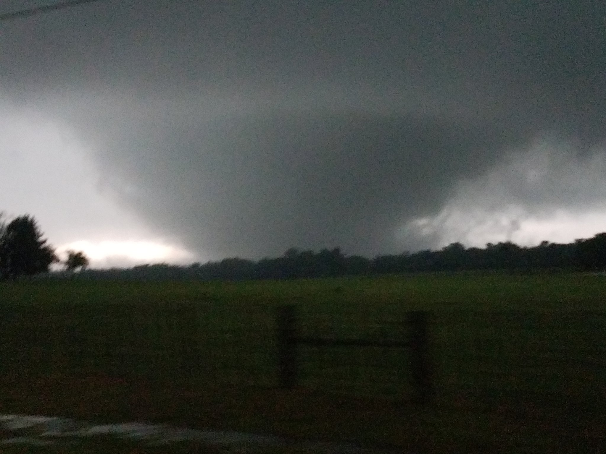
I drove down to see if I could catch that storm for a photo when it was over Natchitoches Parish. I bailed out because it wasn't a photogenic storm at all.
Posted on 4/29/17 at 3:45 pm to ptra
Tornado sirens have been going off in Ruston for the last 20 minutes. Stopped for now
Posted on 4/29/17 at 5:39 pm to Shamet48
PDS Tornado on ground far SE of Dallas...
Severe Weather Statement
National Weather Service Fort Worth TX
531 PM CDT SAT APR 29 2017
TXC213-467-292300-
/O.CON.KFWD.TO.W.0023.000000T0000Z-170429T2300Z/
Van Zandt TX-Henderson TX-
531 PM CDT SAT APR 29 2017
...A TORNADO WARNING REMAINS IN EFFECT UNTIL 600 PM CDT FOR
SOUTHWESTERN VAN ZANDT AND NORTH CENTRAL HENDERSON COUNTIES...
At 530 PM CDT, a confirmed tornado was located near Eustace and
Caney City, or 8 miles east of Gun Barrel City, moving northeast at
20 mph.
This is a PARTICULARLY DANGEROUS SITUATION. TAKE COVER NOW!
HAZARD...Damaging tornado.
SOURCE...Weather spotters confirmed tornado.
IMPACT...You are in a life-threatening situation. Flying debris may
be deadly to those caught without shelter. Mobile homes
will be destroyed. Considerable damage to homes,
businesses, and vehicles is likely and complete destruction
is possible.
Locations impacted include...
Gun Barrel City, Mabank, Malakoff, Eustace, Enchanted Oaks, Caney
City, Purtis Creek State Park, Payne Springs, Log Cabin and Star
Harbor.

Posted on 4/29/17 at 6:26 pm to NorthEndZone
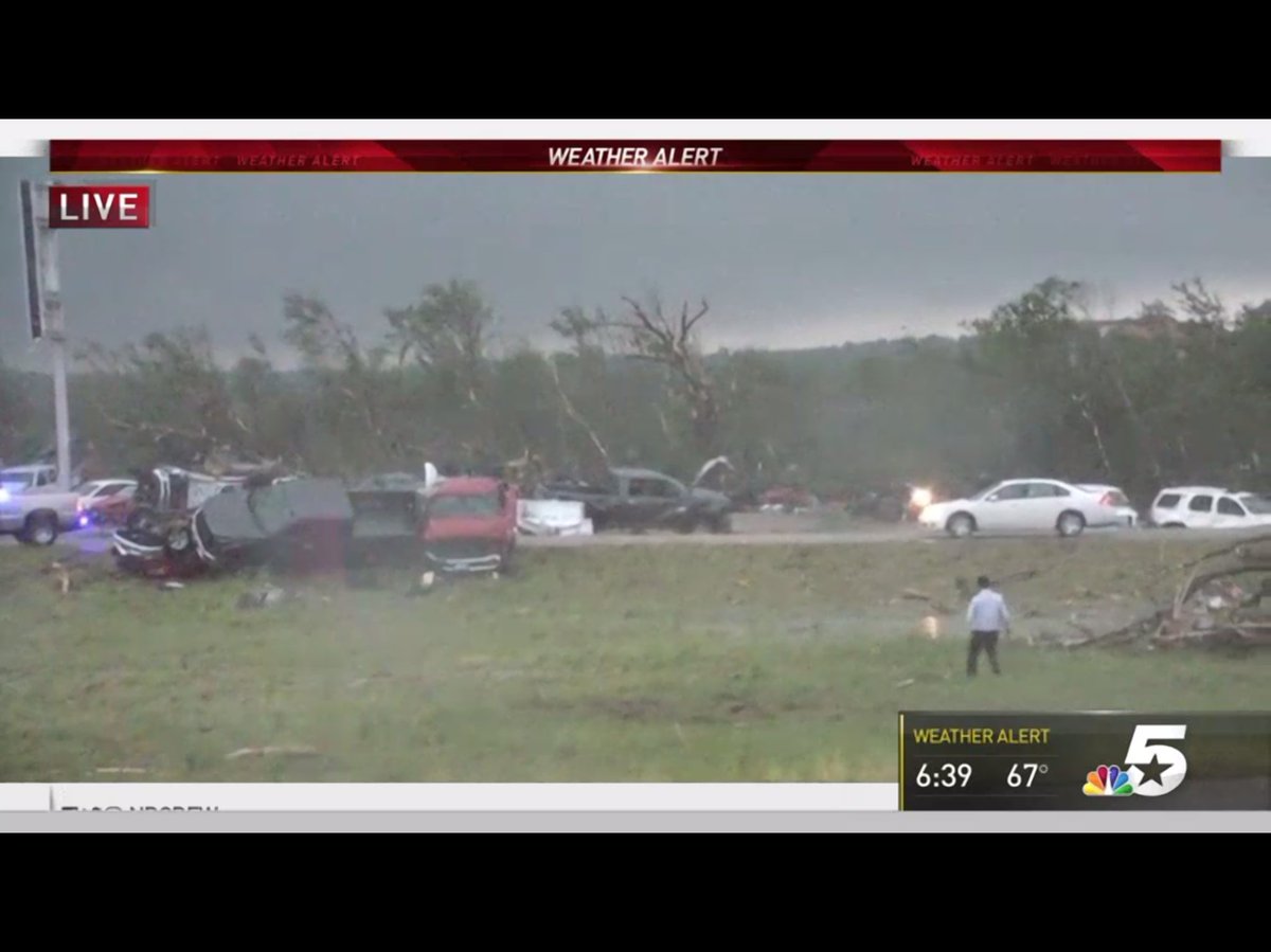
Tornado on the ground near Canton, Texas. Debris signature on radar.
Posted on 4/29/17 at 6:31 pm to Roll Tide Ravens
Within 45 minutes one past just west of Canton and one just east of Canton
Posted on 4/29/17 at 6:33 pm to ptra
This is a large wedge, just saw a picture of it.
Posted on 4/29/17 at 6:36 pm to Roll Tide Ravens
quote:
This is a large wedge, just saw a picture of it.
Posted on 4/29/17 at 6:51 pm to Roll Tide Ravens
Looks like there could be some serious issues with this tornado near Canton, TX

Posted on 4/29/17 at 6:53 pm to rds dc
I use to make the drive A LOT.

Posted on 4/29/17 at 6:58 pm to 50_Tiger
Here comes another one just S of Canton

Posted on 4/29/17 at 7:00 pm to Sao
Tornadoes east and west of Shreveport and we haven't even received any measurable amount of rain today.
So weird.
So weird.
Posted on 4/29/17 at 7:00 pm to Sao
Posted on 4/29/17 at 7:01 pm to Sao
Posted on 4/29/17 at 7:04 pm to rds dc
Damn
Posted on 4/29/17 at 7:05 pm to Salmon
These usually don't head so straight N but thank God selfishly. At my place in Holly Lake Ranch which is just E of all this.

 Page 6 of 17

Popular
Back to top