- My Forums
- Tiger Rant
- LSU Recruiting
- SEC Rant
- Saints Talk
- Pelicans Talk
- More Sports Board
- Fantasy Sports
- Golf Board
- Soccer Board
- O-T Lounge
- Tech Board
- Home/Garden Board
- Outdoor Board
- Health/Fitness Board
- Movie/TV Board
- Book Board
- Music Board
- Political Talk
- Money Talk
- Fark Board
- Gaming Board
- Travel Board
- Food/Drink Board
- Ticket Exchange
- TD Help Board
Customize My Forums- View All Forums
- Show Left Links
- Topic Sort Options
- Trending Topics
- Recent Topics
- Active Topics
Started By
Message

 0
0

Posted on 9/16/17 at 2:19 pm to Cosmo
Exactly. Because we learned from other posters during Irma when it definitely was not going to make that turn...just because one of these hurricanes has yet to completely defy the laws of physics and nature, they definitely will eventually because it's only impossible until it actually happens.
Posted on 9/16/17 at 2:32 pm to rds dc
HMOM plowing it right into the shredder!
Posted on 9/16/17 at 2:48 pm to Cosmo
quote:
GFS and Euro both have it hitting NC outer banks
So by the logic of folks here that means Mobile landfall, its the most logical path
Posted on 9/16/17 at 3:00 pm to otowntiger


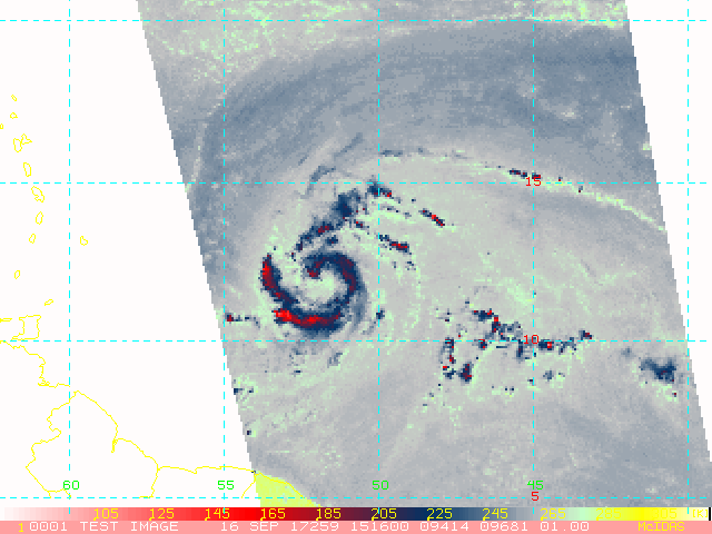
Looks like Maria is organizing quickly not good for those Islands.
This post was edited on 9/16/17 at 3:13 pm

Posted on 9/16/17 at 3:28 pm to lsuman25
Water temp in the area? Shouldn't the ocean still be churned from the other two major hurricanes?
Posted on 9/16/17 at 3:31 pm to 50_Tiger
Water temps will not be a problem unfortunately, also looks to have good upper level winds and no dry air to impede development. My untrained self is that another hurricane will be barreling across those islands late tomorrow into Monday unfortunately.
Posted on 9/16/17 at 3:40 pm to lsuman25
...DEPRESSION BECOMES TROPICAL STORM MARIA... ...ADDITIONAL STRENGTHENING IS FORECAST...
5:00 PM AST Sat Sep 16
Location: 12.3°N 52.6°W
Moving: W at 20 mph
Min pressure: 1002 mb
Max sustained: 50 mph
5:00 PM AST Sat Sep 16
Location: 12.3°N 52.6°W
Moving: W at 20 mph
Min pressure: 1002 mb
Max sustained: 50 mph
Posted on 9/16/17 at 3:42 pm to lsuman25
000
WTNT45 KNHC 162038
TCDAT5
Tropical Storm Maria Discussion Number 2
NWS National Hurricane Center Miami FL AL152017
500 PM AST Sat Sep 16 2017
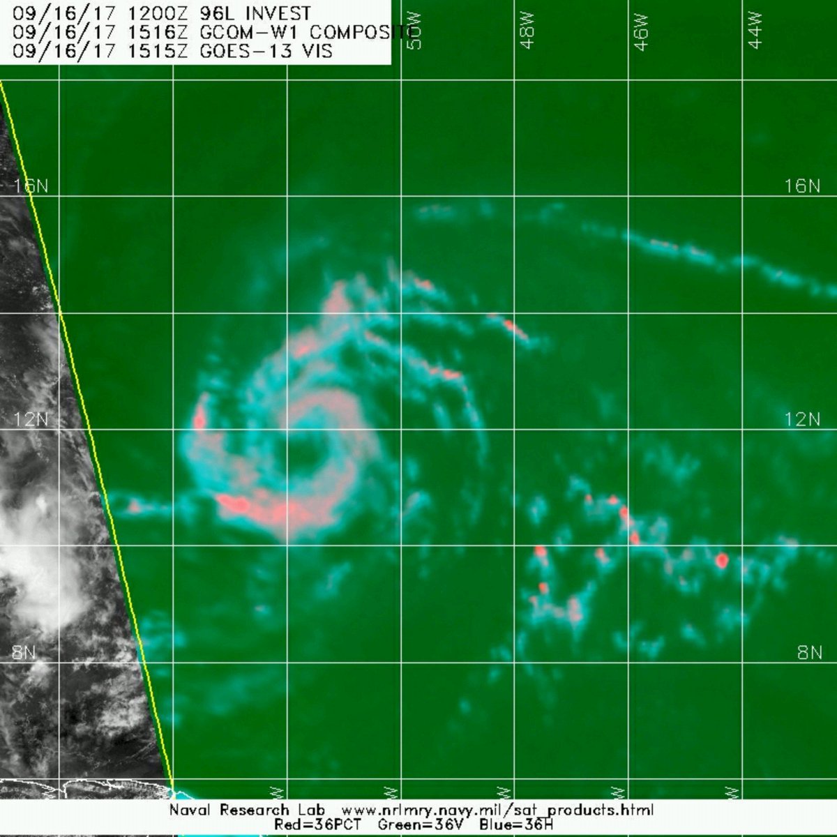
Satellite images indicate that the system located several hundred
miles east of the Lesser Antilles has become much better organized
throughout the day. The low-level center of circulation is now
well defined, and banding features have become better established in
all quadrants. The initial wind speed is increased to 45 kt, in
agreement with a Dvorak classification from TAFB. This makes the
system a tropical storm, Maria becomes the thirteenth named storm
in the Atlantic basin this season.
Maria is moving quickly westward at 17 kt on the south side of a
mid-level ridge. This ridge is expected to remain in place but
weaken some, which should cause Maria to move west-northwestward at
a progressively slower pace through the forecast period. The
models are in fair agreement, and the NHC official track forecast
is closest to the HCCA model. This forecast takes the core of
Maria near the Leeward Islands in 48 to 72 hours, and close to the
Virgin Islands and Puerto Rico in about 4 days.
The tropical storm is located within conducive environmental
conditions of low wind shear, high amounts of moisture, and over
warm 29 deg C SSTs. Since these conditions are not expected to
change much, steady or even rapid strengthening is likely during the
next 3 to 4 days. Slight weakening is predicted by the end of the
forecast period due to some land interaction and a slight increase
in wind shear. The NHC intensity forecast is raised significantly
from the previous one to come into better agreement with the latest
guidance.
KEY MESSAGES:
1. Maria is expected to strengthen and affect portions of the
Leeward Islands as a hurricane early next week, bringing dangerous
wind, storm surge and rainfall hazards. Hurricane and tropical
storm watches have been issued for portions of the Lesser Antilles,
and additional watches will likely be issued tonight and Sunday.
2. Maria could also affect the British and U.S. Virgin Islands and
Puerto Rico by mid week as a dangerous major hurricane, and
hurricane watches could be issued for these islands as early as
Sunday. Interests in these areas should monitor the progress of
Maria and follow any advice given by local officials.
FORECAST POSITIONS AND MAX WINDS
INIT 16/2100Z 12.3N 52.6W 45 KT 50 MPH
12H 17/0600Z 13.0N 54.5W 55 KT 65 MPH
24H 17/1800Z 13.9N 56.6W 65 KT 75 MPH
36H 18/0600Z 14.6N 58.3W 70 KT 80 MPH
48H 18/1800Z 15.2N 59.8W 80 KT 90 MPH
72H 19/1800Z 16.5N 62.7W 95 KT 110 MPH
96H 20/1800Z 17.9N 65.5W 105 KT 120 MPH
120H 21/1800Z 19.5N 68.6W 95 KT 110 MPH
$$
Forecaster Cangialosi
WTNT45 KNHC 162038
TCDAT5
Tropical Storm Maria Discussion Number 2
NWS National Hurricane Center Miami FL AL152017
500 PM AST Sat Sep 16 2017
Satellite images indicate that the system located several hundred
miles east of the Lesser Antilles has become much better organized
throughout the day. The low-level center of circulation is now
well defined, and banding features have become better established in
all quadrants. The initial wind speed is increased to 45 kt, in
agreement with a Dvorak classification from TAFB. This makes the
system a tropical storm, Maria becomes the thirteenth named storm
in the Atlantic basin this season.
Maria is moving quickly westward at 17 kt on the south side of a
mid-level ridge. This ridge is expected to remain in place but
weaken some, which should cause Maria to move west-northwestward at
a progressively slower pace through the forecast period. The
models are in fair agreement, and the NHC official track forecast
is closest to the HCCA model. This forecast takes the core of
Maria near the Leeward Islands in 48 to 72 hours, and close to the
Virgin Islands and Puerto Rico in about 4 days.
The tropical storm is located within conducive environmental
conditions of low wind shear, high amounts of moisture, and over
warm 29 deg C SSTs. Since these conditions are not expected to
change much, steady or even rapid strengthening is likely during the
next 3 to 4 days. Slight weakening is predicted by the end of the
forecast period due to some land interaction and a slight increase
in wind shear. The NHC intensity forecast is raised significantly
from the previous one to come into better agreement with the latest
guidance.
KEY MESSAGES:
1. Maria is expected to strengthen and affect portions of the
Leeward Islands as a hurricane early next week, bringing dangerous
wind, storm surge and rainfall hazards. Hurricane and tropical
storm watches have been issued for portions of the Lesser Antilles,
and additional watches will likely be issued tonight and Sunday.
2. Maria could also affect the British and U.S. Virgin Islands and
Puerto Rico by mid week as a dangerous major hurricane, and
hurricane watches could be issued for these islands as early as
Sunday. Interests in these areas should monitor the progress of
Maria and follow any advice given by local officials.
FORECAST POSITIONS AND MAX WINDS
INIT 16/2100Z 12.3N 52.6W 45 KT 50 MPH
12H 17/0600Z 13.0N 54.5W 55 KT 65 MPH
24H 17/1800Z 13.9N 56.6W 65 KT 75 MPH
36H 18/0600Z 14.6N 58.3W 70 KT 80 MPH
48H 18/1800Z 15.2N 59.8W 80 KT 90 MPH
72H 19/1800Z 16.5N 62.7W 95 KT 110 MPH
96H 20/1800Z 17.9N 65.5W 105 KT 120 MPH
120H 21/1800Z 19.5N 68.6W 95 KT 110 MPH
$$
Forecaster Cangialosi
Posted on 9/16/17 at 3:54 pm to lsuman25

Posted on 9/16/17 at 3:55 pm to lsuman25
Wow! NHC going with agressive intensification prediction. Scary.
This post was edited on 9/16/17 at 3:57 pm
Posted on 9/16/17 at 4:30 pm to lsuman25
Maria stacked up nice from your microwaves. No reason she won't wrap up to a hurricane in pretty short order.
Posted on 9/16/17 at 4:58 pm to Duke
quote:
Maria stacked up nice from your microwaves. No reason she won't wrap up to a hurricane in pretty short order.
Also continues to move almost due west and is well south of early forecast. Maybe a result of the center consolidating farther south than anticipated. Probably won't make a big difference in the lnog range track but could certainly make a difference as it moves into the Islands.

Posted on 9/16/17 at 6:46 pm to rds dc

She's coming.
This post was edited on 9/16/17 at 6:47 pm
Posted on 9/16/17 at 9:28 pm to rds dc

Putting the LSU game out of my mind, Maria getting the convection firing tonight and got a healthy little symmetic envelope of clouds around her. Still needs to fill in on the east side, but making unfortunate progress thus far this evening.

Posted on 9/16/17 at 9:31 pm to Duke
GFS trending back OTS
Posted on 9/16/17 at 9:41 pm to Cosmo
that is good but still a long time to go with this one.
Posted on 9/16/17 at 9:42 pm to lsuman25
GFS and Euro constantly trended west with irma
Last 24 hours have trended east for this which is encouraging
Islands still f'd though
Last 24 hours have trended east for this which is encouraging
Islands still f'd though
Posted on 9/16/17 at 10:19 pm to Cosmo
quote:
by Cosmo
GFS and Euro constantly trended west with irma
Last 24 hours have trended east for this which is encouraging
Depends on the track of Jose. The 12z Euro was all kinds of crazy.
quote:
Islands still f'd though
Hopefully, it stays weak.

Posted on 9/16/17 at 11:55 pm to rds dc
This thread needs to be stickied

 Page 3 of 43

Popular
Back to top