- My Forums
- Tiger Rant
- LSU Recruiting
- SEC Rant
- Saints Talk
- Pelicans Talk
- More Sports Board
- Fantasy Sports
- Golf Board
- Soccer Board
- O-T Lounge
- Tech Board
- Home/Garden Board
- Outdoor Board
- Health/Fitness Board
- Movie/TV Board
- Book Board
- Music Board
- Political Talk
- Money Talk
- Fark Board
- Gaming Board
- Travel Board
- Food/Drink Board
- Ticket Exchange
- TD Help Board
Customize My Forums- View All Forums
- Show Left Links
- Topic Sort Options
- Trending Topics
- Recent Topics
- Active Topics
Started By
Message
re: Hurricane Maria - Visiting the Outer Banks before Moving OTS
Posted on 9/24/17 at 8:26 am to East Coast Band

Posted on 9/24/17 at 8:26 am to East Coast Band

 0
0

Posted on 9/24/17 at 8:58 am to rds dc
Signal continues to grow and the upcoming pattern and climo also favor the WCAB


Posted on 9/24/17 at 9:05 am to rds dc
rds are you burnt out yet? 
Posted on 9/24/17 at 9:10 am to 50_Tiger
quote:
are you burnt out yet?
I'm actually off this weekend for one of the fist times since Harvey
Posted on 9/24/17 at 1:07 pm to rds dc
quote:rds I know it's way early but in looking at that synoptic pattern it tells me that whatever forms in that vicinity it could be going north or northwest, right? Climatology would have this going more NNE or NE due to a trough usually in place by then, but are the troughs arrival coming late this year? I see no trough in the image so it seems to indicate a different outcome than usual for this time of year. Thoughts?
Signal continues to grow and the upcoming pattern and climo also favor the WCAB

Posted on 9/24/17 at 1:22 pm to rds dc
quote:
off this weekend for one of the fist times since Harvey
Dude...TMI

Posted on 9/24/17 at 3:45 pm to otowntiger
What's this stupid thing coming into Destin right now?
Posted on 9/24/17 at 4:04 pm to otowntiger
quote:
I see no trough in the image so it seems to indicate a different outcome than usual for this time of year. Thoughts?
It's ten days out on an ensamble product. Just showing there's a decent possibility of a W Caribbean storm down the line. The exact steering wouldn't be obvious there.
That being said, I'd assume we'd see a trough to throw it east at some point given the time of year.
Posted on 9/24/17 at 4:09 pm to Duke
quote:. Thanks Duke. That's what wanted to know and sort of figured. Climo suggests a trough would be there, but as always depends on the timing. If one is not there at the time or just passed or not there yet, the steering would be affected.
It's ten days out on an ensamble product. Just showing there's a decent possibility of a W Caribbean storm down the line. The exact steering wouldn't be obvious there.
That being said, I'd assume we'd see a trough to throw it east at some point given the time of year.
This post was edited on 9/24/17 at 4:12 pm
Posted on 9/24/17 at 4:10 pm to otowntiger
Posted on 9/24/17 at 4:11 pm to Duke
quote:
It's ten days out on an ensamble product. Just showing there's a decent possibility of a W Caribbean storm down the line. The exact steering wouldn't be obvious there. That being said, I'd assume we'd see a trough to throw it east at some point given the time of year.
So ABC Islands?
I hope not, will be in Aruba 28th-oct6th. No where to hide there.
Posted on 9/24/17 at 4:15 pm to SeeeeK
North of the ABCs. They are a little south to get many tropical strikes.
Posted on 9/24/17 at 9:44 pm to rds dc
Can you remind me where you work??? Sorry if I shouldn't be asking.
Posted on 9/24/17 at 9:46 pm to Duke
And what's ABC islands???

Posted on 9/25/17 at 12:49 pm to tiger91


Posted on 9/25/17 at 4:57 pm to East Coast Band
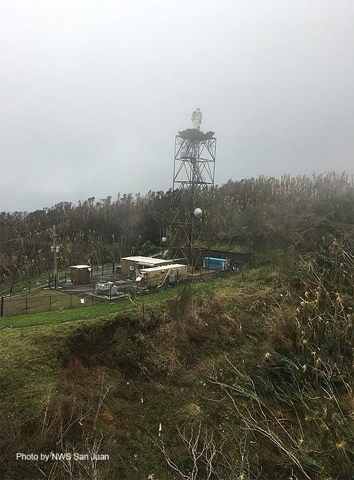
This is what is left of the NEXRAD radar site in Puerto Rico:
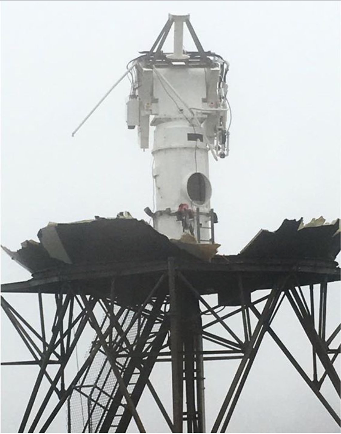
This is what a NEXRAD radar is supposed to look like:

This is what a NEXRAD radar is supposed to look like:
Posted on 9/26/17 at 9:55 am to Roll Tide Ravens
More pictures here LINK
Posted on 9/26/17 at 2:20 pm to Jim Rockford
quote:WOW. I don't think the breadth of this catastrophe has been fully realized. The new media has dropped this story like a hot potato and moved on. The citizens of this territory/commonwealth/island whatever you want to call it, are in for a very very long, hard recovery. There will be far, far more post storm casualties than there were during the storm. And I'm sure there are many more casualties that haven't been determined.
More pictures here LINK

 Page 43 of 43


Popular
Back to top