- My Forums
- Tiger Rant
- LSU Recruiting
- SEC Rant
- Saints Talk
- Pelicans Talk
- More Sports Board
- Fantasy Sports
- Golf Board
- Soccer Board
- O-T Lounge
- Tech Board
- Home/Garden Board
- Outdoor Board
- Health/Fitness Board
- Movie/TV Board
- Book Board
- Music Board
- Political Talk
- Money Talk
- Fark Board
- Gaming Board
- Travel Board
- Food/Drink Board
- Ticket Exchange
- TD Help Board
Customize My Forums- View All Forums
- Show Left Links
- Topic Sort Options
- Trending Topics
- Recent Topics
- Active Topics
Started By
Message
re: Preliminary Ratings: Lacombe Tornado - EF1; NOLA/Arabi Tornado - EF3
Posted on 3/23/22 at 3:20 pm to LegendInMyMind
Posted on 3/23/22 at 3:20 pm to LegendInMyMind
So anyone got any idea on the severe threat next Wednesday? Temps will be in the 80s across the South I figure that cold front Wednesday will be the next event
 2
2

Posted on 3/23/22 at 3:26 pm to deltaland

Ensembles have something and analogs are showing up with a threat in the SE.
Thats all I got for you at this point. Im not ready to dig into that just yet.
Posted on 3/23/22 at 3:34 pm to deltaland
quote:
So anyone got any idea on the severe threat next Wednesday? Temps will be in the 80s across the South I figure that cold front Wednesday will be the next event
next Wednesday being March 30th...
all I can recall is during the late afternoon when everyone was screaming "BUST!!!"... Reed Timmer texted Ryan Hall (which Ryan read on his stream) to essentially start prepping for a March 29-31 event... and that was pretty much it
so yeah... that's where we're at
Posted on 3/23/22 at 3:36 pm to Duke
NWS Chat
quote:
218
NOUS44 KLIX 232011
PNSLIX
LAZ034>037-039-046>050-056>061-063>072-075>078-MSZ068>071-077-
080>082-240015-
PUBLIC INFORMATION STATEMENT
NATIONAL WEATHER SERVICE NEW ORLEANS LA
311 PM CDT WED MAR 23 2022
...NWS METEOROLOGISTS REVIEWING SURVEY STORM DAMAGE FROM GRETNA TO
ARABI TO NEW ORLEANS EAST WITH PRELIMINARY RATING OF EF-3...
THE NATIONAL WEATHER SERVICE OFFICE IN NEW ORLEANS LA IS
CURRENTLY REVIEWING DATA FROM TODAY'S STORM SURVEY. THE
APPROXIMATE 11 MILE PATH OF THE TORNADO EXTENDS FROM AROUND
GRETNA (JEFFERSON PARISH) TO ARABI (ST BERNARD PARISH) TO NEW
ORLEANS EAST (ORLEANS PARISH) LOUISIANA. THE SURVEY IS IN RELATION
TO THE SEVERE THUNDERSTORMS THAT MOVED THROUGH THE AREA ON THE
EVENING OF MARCH 22, 2022. THE DAMAGE WAS MOST INTENSE IN ARABI
AND WAS RATED THERE AS EF-3.
A FINAL ASSESSMENT INCLUDING RESULTS OF THE ENTIRE SURVEY ARE
EXPECTED TO BE COMPLETED AND TRANSMITTED VIA A PUBLIC INFORMATION
STATEMENT TOMORROW, THURSDAY MARCH 24TH. WE THANK YOU FOR YOUR
PATIENCE.
THE STORM SURVEY INFORMATION WILL ALSO BE AVAILABLE ON OUR
WEBSITE AT HTTP://WWW.WEATHER.GOV/LIX
$$
SCHOTT
Posted on 3/23/22 at 4:39 pm to rt3
quote:
Reed Timmer texted Ryan Hall (which Ryan read on his stream) to essentially start prepping for a March 29-31 event... and that was pretty much it
so yeah... that's where we're at
Baw, I live in North Alabama. I start ducking on March 1st and don't stick my head up until the first day of June.
Posted on 3/23/22 at 4:54 pm to LegendInMyMind
Same. I'm in Marshall County. There are way too many twisters around here for my taste.
Posted on 3/23/22 at 5:40 pm to Duke
quote:
Did Zach Fradella steal a lot of my thunder this morning with his breakdown? Yes.
Did I do enough already to not want to waste that work?
Also yes.
There's enough to go around, baw. That's how we learn, with all the eyes on it. Good work.
Posted on 3/23/22 at 5:45 pm to LegendInMyMind
I got over 4" of rain from the line last night. That's the hardest I've seen it rain in several years.
Northwest AL recorded an EF0 near Rogersville.
Northwest AL recorded an EF0 near Rogersville.
Posted on 3/23/22 at 5:50 pm to LegendInMyMind
To the guy who was talking about storm chasing the other night, and to anyone else interested, start here. This is the NWS Birmingham class, but all NWS WFOs have these classes. Take the Basic class and the Advanded class later.
@NWSBirmingham
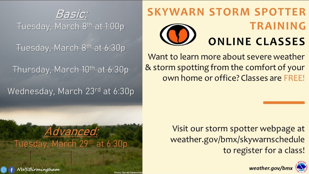
@NWSBirmingham
quote:
Tonight is our last basic (intro) storm spotter class for the spring season! Register for this free, online class at LINK. If you've taken a basic class at least once, sign up for our advanced class if you want to dive deeper. #alwx LINK
Posted on 3/23/22 at 9:25 pm to LegendInMyMind
North Carolina is getting in on the action tonight. Three different warnings on three storms in a row right now
Posted on 3/23/22 at 10:07 pm to LegendInMyMind
Don't know who will still read this, but apparently a dude showed up at the Arabi damage in a NWS shirt, acted like a NWS employee/surveyor, and went on air with CNN and gave an interview.

Posted on 3/23/22 at 10:10 pm to LegendInMyMind
If he was attractive it was me
Posted on 3/23/22 at 10:12 pm to The Boat
Is this you?
@stormchasernick

@stormchasernick
Posted on 3/23/22 at 10:15 pm to LegendInMyMind
The video is on Twitter if you search CNN NWS. I don’t know what’s funnier. The guy doing this or the weather neckbeards on Twitter freaking out over it like he said the weather version of the n-word.
Posted on 3/23/22 at 10:17 pm to The Boat
quote:
I don’t know what’s funnier. The guy doing this or the weather neckbeards on Twitter freaking out over it like he said the weather version of the n-word.
I saw the video. WxTwitter will take any type of drama to 1,000 and it doesn't have to be much of anything.
ETA: Reed is probably kind of thankful he came along because he was getting bashed for passing someone last night. The horror.
This post was edited on 3/23/22 at 10:18 pm
Posted on 3/23/22 at 10:50 pm to The Boat
WX twitter loves some drama.
When the real villain is CNN for not bothering to check credentials beside his shirt.
When the real villain is CNN for not bothering to check credentials beside his shirt.
Posted on 3/24/22 at 2:06 pm to rt3
quote:
NWS New Orleans @NWSNewOrleans
[Corrected Graphic] Here is the latest track map on the EF-3 Arabi Tornado on March 22nd. There still may be more refinements to this track as we analyze more data.
More details can be found in our public information statement here: NWS Chat
#LAwx #tornado
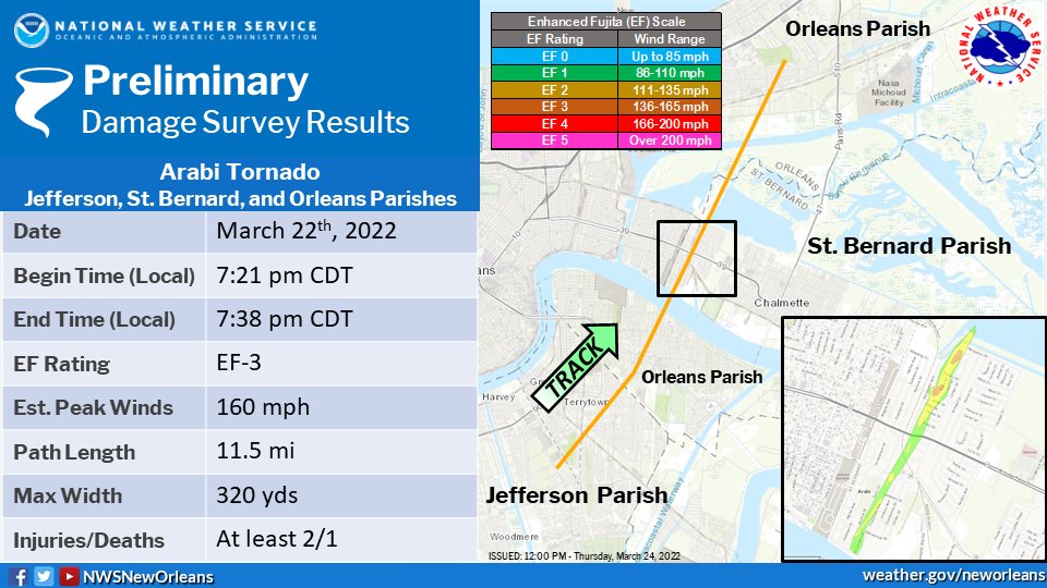
quote:
161
NOUS44 KLIX 241635
PNSLIX
LAZ034>037-039-046>050-056>061-063>072-075>078-MSZ068>071-077-
080>082-242045-
PUBLIC INFORMATION STATEMENT
NATIONAL WEATHER SERVICE NEW ORLEANS LA
1135 AM CDT THU MAR 24 2022
...NWS DAMAGE SURVEY FOR MARCH 22, 2022 TORNADO EVENT...
...UPDATE...ARABI TORNADO INFORMATION ADDED TO THE LACOMBE
TORNADO INFORMATION...
..ARABI, LA EF3 TORNADO...
RATING: EF3
ESTIMATED PEAK WIND: 160 MPH
PATH LENGTH /STATUTE/: 11.5 MILES
PATH WIDTH /MAXIMUM/: 320 YARDS
FATALITIES: 1
INJURIES: UNKNOWN, BUT AT LEAST 2
START DATE: 03/22/2022
START TIME: 07:21 PM CDT
START LOCATION: 1 E HARVEY / JEFFERSON PARISH / LA
START LAT/LON: 29.8849 / -90.0535
END DATE: 03/22/2022
END TIME: 07:38 PM CDT
END LOCATION: 3 SSW EAST NEW ORLEANS / ORLEANS PARISH /
LA
END LAT/LON: 30.0292 / -89.9604
SURVEY SUMMARY:
A TORNADO TOUCHED DOWN IN JEFFERSON PARISH, SOUTHWEST OF
TERRYTOWN. IT MOVED NORTHEAST THROUGH JEFFERSON PARISH AND INTO
ORLEANS PARISH. AS IT MOVED NORTHEAST THROUGH THE WESTBANK, IT
CAUSED MINOR TREE DAMAGE AS WELL AS STRUCTURAL DAMAGE. THIS DAMAGE
CONSISTED OF MINOR ROOF, SIDING AND FENCE DAMAGE. THERE WAS VIDEO
FOOTAGE OF THE TORNADO CROSSING THE MISSISSIPPI RIVER AND DAMAGE
WAS FOUND ON THE EASTBANK AS IT MOVED INTO ST. BERNARD PARISH,
INTO THE TOWN OF ARABI. THE MOST INTENSE DAMAGE WAS FROM THE
RIVERBANK TO THE CANAL IN ARABI. IT WAS A VERY NARROW, INTENSE
TORNADO WITH TWO AREAS OF CONCENTRATED EF3 DAMAGE. ONE WAS A HOUSE
THAT WAS SWEPT OFF ITS RAISED FOUNDATION WITH ALL WALLS AND THE
ROOF DESTROYED. THIS WAS NEAR WHERE THE ONE FATALITY OCCURRED. DUE
TO POOR CONSTRUCTION, THIS WAS EF3. THE HIGHEST EF3 RATING WAS
GIVEN TO A HOUSE THAT WAS CONSTRUCTED IN THE LAST 6 MONTHS. WHILE
THIS HOUSE WAS RAISED ON CINDER BLOCKS, EVERY TOWER OF BLOCKS HAD
STRAPPING TO THE HOUSE. THE HOUSE HAD ADDITIONAL STRAPPING
DIRECTLY INTO THE FOUNDATION, AS WELL AS STRAPPING FROM THE CINDER
BLOCKS TO THE FOUNDATION. THE HOUSE ITSELF HELD TOGETHER BUT WAS
SHIFTED ABOUT 50 YARDS TO THE NORTH AND ROTATED ABOUT 90 DEGREES.
THE HOUSE NEXT DOOR WAS ALSO SWEPT OFF THE FOUNDATION, MOVED AND
MOSTLY DESTROYED. THIS ALSO HAD SOME EVIDENCE OF STRAPPING TO THE
SLAB FOUNDATION. THIS AREA IS WHAT WILL JUSTIFY THE 160 MPH EF3
RATING. MOST IF NOT ALL HOUSES ON THE SOUTH TO NORTH PATH WITHIN A
4 BLOCK WEST TO EAST RANGE RECEIVED MINOR TO SUBSTANTIAL ROOF
DAMAGE WITH MANY HOUSES SEEING WALLS COLLAPSED, LEAVING INTERIOR
ROOMS INTACT. THE TORNADO THEN DAMAGED ELECTRICAL TOWERS ON THE
BANK OF THE CANAL BEFORE MOVING NORTHEAST ACROSS THE CANAL. DAMAGE
WAS NOTED ON THE OTHER SIDE OF THE INTRACOASTAL WATERWAY IN NEW
ORLEANS EAST AND CONTINUED NORTHEAST. THIS DAMAGE WAS MINOR TREE
DAMAGE AND MINOR ROOF AND SIDING DAMAGE. IT IS ESTIMATED THE
TORNADO LIFTED BEFORE JOE W BROWN MEMORIAL PARK. THERE WERE ALSO
AT LEAST TWO INJURIES NOTED FROM THE SURVEY BUT ADDITIONAL
INJURIES WILL NEED TO BE REPORTED FROM THE LOCAL OFFICIALS.
SATELLITE DATA HAS STILL NOT YET BEEN RECEIVED AND DRONE VIDEO HAS
NOT BEEN FULLY ANALYZED. LENGTH, WIDTH AND TIMING INFORMATION MAY
BE UPDATED IN THE COMING DAYS. THIS DATA IS ALL PRELIMINARY UNTIL
IT IS FINALIZED IN THE OFFICIAL NWS STORM DATA RECORD.
SPECIAL THANKS TO ST. BERNARD, JEFFERSON AND NEW ORLEANS PARISH EMERGENCY
MANAGEMENT AND SAFETY OFFICIALS.
NASH/DUPLANTIS
This post was edited on 3/24/22 at 2:08 pm
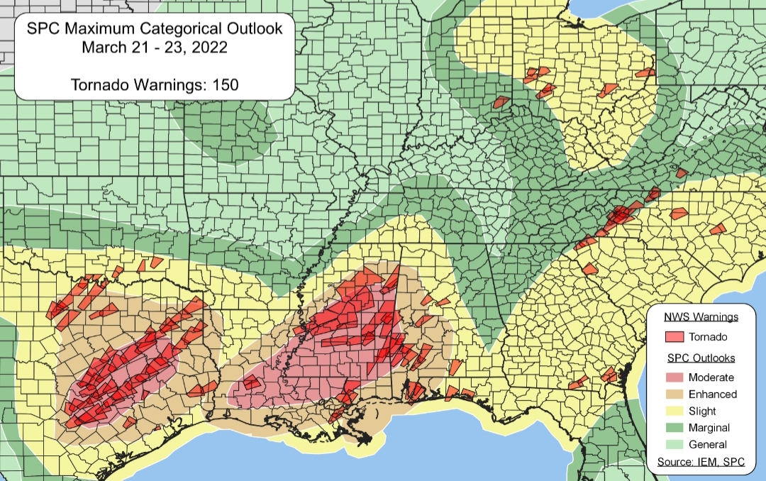
Posted on 3/24/22 at 10:56 pm to rt3
Pretty damn good after all. The Arabi/NOLA tornado proved why the SPC went with the MOD Risk and didn't trim it back throughout the day. They absolutely nailed the Texas setup. I haven't seen confirmation on the NC storms, yet. The border areas between risk categories prove once again that it will always be a mistake to take those lines to heart.
Posted on 3/24/22 at 11:05 pm to LegendInMyMind
USA! Draw at Azteca is still a beautiful thing. Not as beautiful as a win... but a result is useful.
But yeah Legend, there is that glaring hole in the southern extent of the moderate but its hard to say the SPC got it all that wrong. Not sure how to justify a lower risk with the ridiculous soundings LIX was throwing out.
But yeah Legend, there is that glaring hole in the southern extent of the moderate but its hard to say the SPC got it all that wrong. Not sure how to justify a lower risk with the ridiculous soundings LIX was throwing out.
Posted on 3/25/22 at 9:56 am to Duke


 Page 93 of 94

Popular
Back to top