- My Forums
- Tiger Rant
- LSU Recruiting
- SEC Rant
- Saints Talk
- Pelicans Talk
- More Sports Board
- Fantasy Sports
- Golf Board
- Soccer Board
- O-T Lounge
- Tech Board
- Home/Garden Board
- Outdoor Board
- Health/Fitness Board
- Movie/TV Board
- Book Board
- Music Board
- Political Talk
- Money Talk
- Fark Board
- Gaming Board
- Travel Board
- Food/Drink Board
- Ticket Exchange
- TD Help Board
Customize My Forums- View All Forums
- Show Left Links
- Topic Sort Options
- Trending Topics
- Recent Topics
- Active Topics
Started By
Message
re: Preliminary Ratings: Lacombe Tornado - EF1; NOLA/Arabi Tornado - EF3
Posted on 3/23/22 at 11:55 am to Duke
Posted on 3/23/22 at 11:55 am to Duke
quote:
Just think about how much wasnt hit by a tornado on 4/27/11 and how that was the worst case scenario tornado outbreak.
That's a good way to put it, too.
 1
1

Posted on 3/23/22 at 12:02 pm to Duke
That can really help calm the nerves when you look at the SPC map and see your house right in the middle of a High Risk area. That's how I've started approaching it with my Mom, who is prone to panic. I just remind her how small a tornado is in the grand scheme of things. It helps some.
What doesn't help is that our area has been in more High Risk days than maybe anywhere. I counted it once, but I forget now. Too many, I suppose.
I usually always win those Twitter polls that ask how many of those days people have been in. Not bragging, of course, just reality.
What doesn't help is that our area has been in more High Risk days than maybe anywhere. I counted it once, but I forget now. Too many, I suppose.
I usually always win those Twitter polls that ask how many of those days people have been in. Not bragging, of course, just reality.

Posted on 3/23/22 at 12:05 pm to LegendInMyMind
quote:
That can really help calm the nerves when you look at the SPC map and see your house right in the middle of a High Risk area. That's how I've started approaching it with my Mom, who is prone to panic. I just remind her how small a tornado is in the grand scheme of things.
Tornadoes are very localized, especially compared to the widespread damage seen during a major hurricane.
We literally had a tornado hit our house, and we lost a bunch of trees, etc. and houses less than a block away didn't even lose a leaf out of their yard
Posted on 3/23/22 at 12:06 pm to LegendInMyMind
The damage in "North Arabi" near Benajmin / Center Streets and the 40 Arpent Canal is really sad.
This was an area that, like most of St. Bernard, was completely obliterated by Katrina. Huge sections of that area were knocked down and were green space for years.
Within the last 2-3 years, houses have been going up like crazy in that area. There is a lot of new houses under construction in that area.
The prices they are asking for them - like all new houses - is nuts.
But.. driving by... looking at them as they are built... they didn't look... sturdy.
Many of them were raised a few feet off the ground - obviously to avoid flooding. Very few few of then had any brick whatsoever. A whole lot of white vunyl and hardi-plank. A whole lot of nice, white and gray features on the inside.
I assume they were built to code. But they were built fast. And I don't know how strong the code in St. Bernard is... or how well it was enforced. A lot of the builders here are small outfits who bought lots from the parish / road home, and build 2-3 houses at a time, sell, then build 2-3 more.
I think this will be something to pay attention to in the weeks ahead.
Posted on 3/23/22 at 12:22 pm to LSUFanHouston
quote:
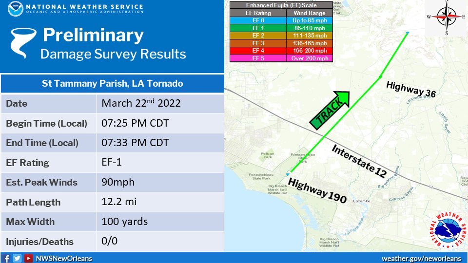
NWS New Orleans @NWSNewOrleans
Here is a graphic showing the track and details on the Lacombe, LA tornado that occurred between 7:25pm and 7:33pm last night. Survey showed damage indicating an EF1 rating with max winds of 90mph, a max width of 100 yards, and a path length of 12.2 miles. #lawx
Posted on 3/23/22 at 12:26 pm to rt3
NWS Chat
quote:
709
NOUS44 KLIX 231549
PNSLIX
LAZ034>037-039-046>050-056>061-063>072-075>078-MSZ068>071-077-
080>082-232000-
PUBLIC INFORMATION STATEMENT
NATIONAL WEATHER SERVICE NEW ORLEANS LA
1049 AM CDT WED MAR 23 2022
...NWS DAMAGE SURVEY FOR MARCH 22, 2022 TORNADO EVENT ...
.LACOMBE TORNADO...
RATING: EF1
ESTIMATED PEAK WIND: 90 MPH
PATH LENGTH /STATUTE/: 12.2 MILES
PATH WIDTH /MAXIMUM/: 100 YARDS
FATALITIES: 0
INJURIES: 0
START DATE: 03/22/2022
START TIME: 7:25 PM CDT
START LOCATION: 3.8 MILES WNW LACOMBE/ST. TAMMANY LA
START LAT/LON: 30.337/-90008
END DATE: 03/22/2022
END TIME: 7:33 PM CDT
END LOCATION: 11.85 NNE LACOMBE/ST.TAMMANY LA
END LAT/LON: 30.4782/-89.8802
SURVEY SUMMARY:
A TORNADO TOUCHED DOWN NEAR BIG BRANCH MARSH NATIONAL WILDLIFE
REFUGE ON HIGHWAY 190. DAMAGE BEGAN AT HOMES JUST NORTH OF 190,
INCLUDING MINOR ROOF DAMAGE, A SHED DESTROYED, AND DOZENS OF TREES
SNAPPED. TORNADO CONTINUED NE AND SIMILAR DAMAGE WAS NOTED ALONG
AZALEA ST AND CANE BAYOU LN. A TREE WAS UPROOTED ON THE CORNER OF
LOUND DR AND BLACKWELL DR. TORNADO CROSSED I-12 AND CONTINUED NE
TO FISH HATCHERY RD. RADAR SHOWED A TDS IN RURAL AREAS BETWEEN 190
AND FISH HATCHERY RD. TORNADO TRACK CONTINUED NE AND BEGAN TO
TRACK ALONG HIGHWAY 1088 JUST SW OF HIGHWAY 36. IN THIS AREA,
DOZENS OF TREES WERE DOWNED AND SNAPPED ALONG THE HIGHWAY. BASED
ON RADAR TDS THE TORNADO CONTINUED ANOTHER 3 MILES NORTH OF
HIGHWAY 36,IN RURAL AREAS. THE GENERAL TYPE OF DAMAGE SEEN
THROUGHOUT THE PATH OF THE TORNADO RANGED FROM STRONG EF0 TO WEAK
EF1, WITH A MAX WIND RATING OF 90MPH.
&&
EF SCALE: THE ENHANCED FUJITA SCALE CLASSIFIES TORNADOES INTO THE
FOLLOWING CATEGORIES:
EF0...WEAK......65 TO 85 MPH
EF1...WEAK......86 TO 110 MPH
EF2...STRONG....111 TO 135 MPH
EF3...STRONG....136 TO 165 MPH
EF4...VIOLENT...166 TO 200 MPH
EF5...VIOLENT...>200 MPH
NOTE:
THE INFORMATION IN THIS STATEMENT IS PRELIMINARY AND SUBJECT TO
CHANGE PENDING FINAL REVIEW OF THE EVENT AND PUBLICATION IN NWS
STORM DATA.
$$
HL/ME
Posted on 3/23/22 at 12:31 pm to ReadyPlayer1
quote:
It's in this analyzing video about the 1:30 mark
fox 8
wdsu video of it crossing the river
Wow. That's a really interesting video. Thanks for posting!
Posted on 3/23/22 at 12:42 pm to rt3
quote:
THE NATIONAL WEATHER SERVICE OFFICE IN NEW ORLEANS LA IS
CURRENTLY CONDUCTING A STORM SURVEY FOR THE AREA NEAR ARABI IN ST
BERNARD PARISH LOUISIANA. THE SURVEY IS IN RELATION TO THE SEVERE
THUNDERSTORMS THAT MOVED THROUGH THE AREA ON 03/22/2022. CURRENT
DAMAGE REVIEWED SHOWS AT LEAST EF-3 DAMAGE OCCURED LAST EVENING.
Serious question for you mets.. what’s the deal with the NWS and caps lock?
Posted on 3/23/22 at 1:32 pm to lostinbr
quote:Goes back to the days of teletype machines. As do I: I can still hear the sound of the AP wire machine down the hallway at my first job.
what’s the deal with the NWS and caps lock?
Posted on 3/23/22 at 1:42 pm to DoctorTechnical
quote:quote:
what’s the deal with the NWS and caps lock?
Goes back to the days of teletype machines. As do I: I can still hear the sound of the AP wire machine down the hallway at my first job.
fun fact... news stories are written in all caps because it's easier to read out of the teleprompter
wouldn't be that surprised if that was part of the reason the NWS does it... easy for news people to more easily read the information out to the people while likely reading it for the first time themselves
Posted on 3/23/22 at 1:49 pm to rt3
quote:
fun fact... news stories are written in all caps because it's easier to read out of the teleprompter
wouldn't be that surprised if that was part of the reason the NWS does it... easy for news people to more easily read the information out to the people while likely reading it for the first time themselves
I also wonder if this has to do with old government tech not being replaced / upgraded.
Like the horrible voices on the warning blasts.
Posted on 3/23/22 at 1:54 pm to rt3
Curious... do we know why last night the second/updated warning was a PDS warning and not a Tornado Emergency?
Was it not bad enough for a Tornado Emergency?
Was it not bad enough for a Tornado Emergency?

Posted on 3/23/22 at 2:06 pm to lostinbr
quote:
Serious question for you mets.. what’s the deal with the NWS and caps lock?
Fewer characters to have to encode and send out. Remember that NWS provides many of its products over radio and can provide weather reports that can be received hundreds or thousands of miles from the transmitter. These are not just the voice communications you might think of with a typical weather radio. The NWS broadcasts a pretty large number of non-voice products over the longer range radio frequencies they use. The fewer characters you have to encode, the simpler and more robust the communications can be when conditions are less than ideal, like when the weather is bad. This system is many decades old and if it ain't broke, don't fix it.
They broadcast weather maps and graphical products by radiofax, as well. Most of it (especially the marine products) is simple black and white instead of color or grayscale because encoding 1 and 0 over a radio link is much simpler than encoding more colors or shades. Given that these types of radio transmissions use a fixed bandwidth, keeping it simple provides for more forgiveness and quality of transmission when communications are spotty, again, as they often are for mariners or pilots navigating near and around bad weather.
This post was edited on 3/23/22 at 2:16 pm
Posted on 3/23/22 at 2:09 pm to Thracken13
quote:
Tornado room
We bought in 2014 and our builder (who was living in it at the time, and now lives just down the street) put in a full shelter off the basement, complete with bunk beds. We thought it was overkill at the time (we weren’t here for Tuscaloosa in 2011) but are glad we have it now. We were in there last night for the warned storm by McCalla that was forecast to go right over us but lifted before it got very far.
The Pelham/Eagle Point EF-3 from last year wasn’t far away, but fortunately wasn’t deadly. We do get quite a few storms around here, but not the monsters like they do up on Sand Mountain. How many times has Hackleburg been rebuilt?
Posted on 3/23/22 at 2:18 pm to LSUFanHouston
quote:
Curious... do we know why last night the second/updated warning was a PDS warning and not a Tornado Emergency?
Was it not bad enough for a Tornado Emergency?
I asked that question in real time too
I know the NWS has the news stations on in their office... I guarantee you they saw the WDSU video live like we all did... they knew a tornado was on the ground in a densely populated area
ETA: the only out I will give them is perhaps they were about to go take shelter from a possible strike from the Lacombe tornado... but that was several miles away
This post was edited on 3/23/22 at 2:25 pm
Posted on 3/23/22 at 2:20 pm to Crawdaddy
Visual depiction of the “I-59 Shield”
/cloudfront-us-east-1.images.arcpublishing.com/gray/C4E3VOODDJEFLDLFMTHJXF6EZ4.jpg)
Map of just F/EF-5s since 1950:
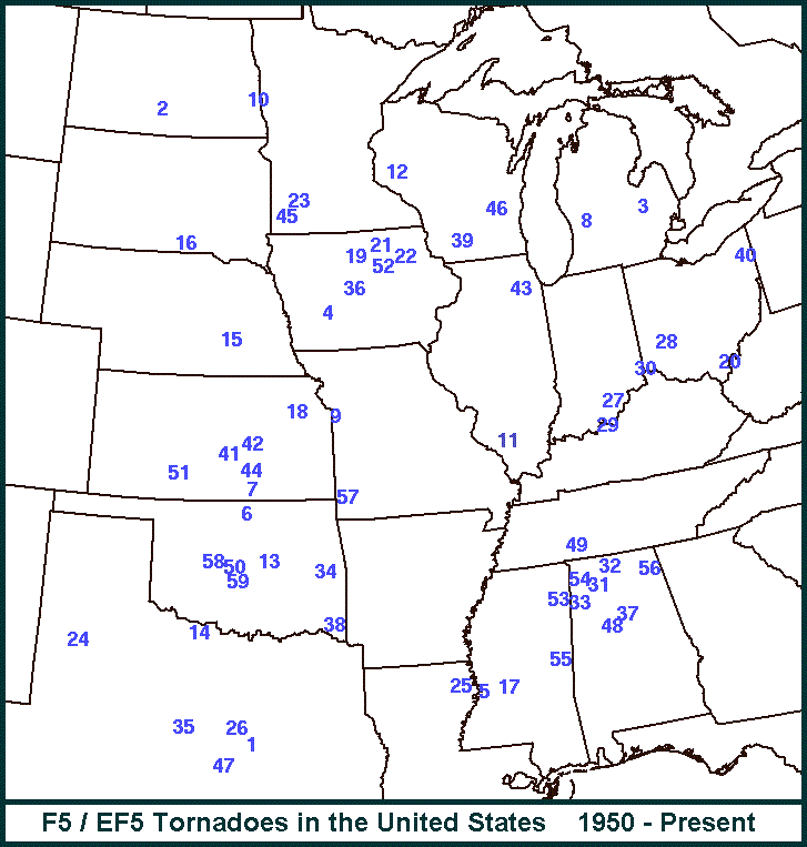
Map of just F/EF-5s since 1950:
This post was edited on 3/23/22 at 2:28 pm
Posted on 3/23/22 at 2:41 pm to RockChalkTiger
Quick Case Study of the Arabi Tornado
Did Zach Fradella steal a lot of my thunder this morning with his breakdown? Yes.
Did I do enough already to not want to waste that work?
Also yes.
Did Zach Fradella steal a lot of my thunder this morning with his breakdown? Yes.
Did I do enough already to not want to waste that work?
Also yes.

Posted on 3/23/22 at 3:03 pm to Duke
Will read this tonight but it’s either a very crazy coincidence or something way above my understanding of weather but it’s crazy that the only 2 times in recorded history the south shore gets a F3 another supercell produces a tornado on the northshore at the exact same time and almost identical tracks on both sides of the lake both times. I’ll hang up and listen
This post was edited on 3/23/22 at 3:04 pm
Posted on 3/23/22 at 3:08 pm to Ba Ba Boooey
That February one a few years back is probably worth a case study too. Overall it was a very different setup but with somewhat similar results in NOLA at least.
That was a weird day in Louisiana, with textbook looking supercells running west to east.
That was a weird day in Louisiana, with textbook looking supercells running west to east.

 Page 92 of 94

Popular
Back to top