- My Forums
- Tiger Rant
- LSU Recruiting
- SEC Rant
- Saints Talk
- Pelicans Talk
- More Sports Board
- Fantasy Sports
- Golf Board
- Soccer Board
- O-T Lounge
- Tech Board
- Home/Garden Board
- Outdoor Board
- Health/Fitness Board
- Movie/TV Board
- Book Board
- Music Board
- Political Talk
- Money Talk
- Fark Board
- Gaming Board
- Travel Board
- Food/Drink Board
- Ticket Exchange
- TD Help Board
Customize My Forums- View All Forums
- Show Left Links
- Topic Sort Options
- Trending Topics
- Recent Topics
- Active Topics
Started By
Message
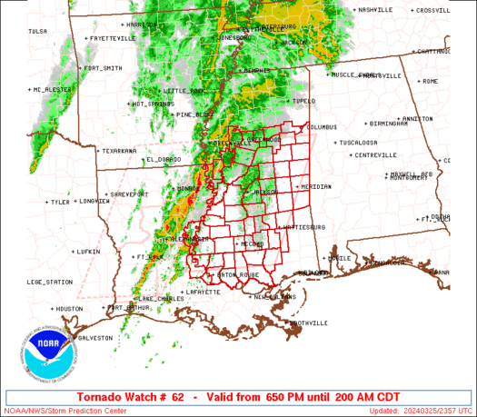
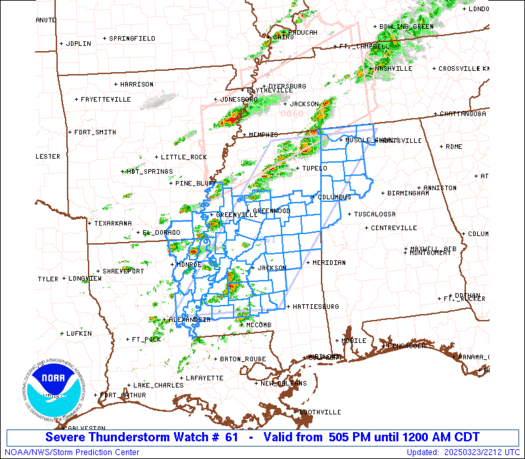
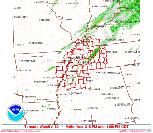
Southern Severe Weather Threat (Thursday/Friday)
Posted on 2/26/23 at 8:14 pm
Posted on 2/26/23 at 8:14 pm


quote:
SPC AC 031611
Day 1 Convective Outlook
NWS Storm Prediction Center Norman OK
1011 AM CST Fri Mar 03 2023
Valid 031630Z - 041200Z
...THERE IS AN ENHANCED RISK OF SEVERE THUNDERSTORMS TN/OH VALLEYS
TO THE SOUTHERN APPALACHIANS...
...SUMMARY...
Numerous tornadoes and scattered swaths of severe damaging winds are
probable into this evening from the Tennessee to Ohio Valleys
towards the southern Appalachians. A few tornadoes may be strong
(EF-2) with the greatest chance across parts of Kentucky and
Tennessee.
...TN to OH Valleys and the central/southern Appalachians...
Two primary areas of convective activity are ongoing from MS/AL/TN
border area northwest to the confluence of the MS/OH Rivers. Leading
pre-frontal squall, low-topped near the central MS/AL border with
progressively deeper tops northward, will likely persist
east-northeast this afternoon and reach the southern Appalachians by
early evening. With broken cloudiness across AL and richer
boundary-layer moisture, sampled by the 12Z LIX sounding, advecting
north from the central Gulf Coast, this QLCS should ingest the
northern gradient of peak surface-based buoyancy. This should result
in intensification of the squall line with embedded QLCS tornadoes
and damaging winds as the primary hazards.
Farther north, broken convective bands are evident along the
northern periphery of the warm sector near the MS/OH Rivers
confluence, close to the deep surface cyclone. A robust surface
pressure rise-fall couplet and the extreme low to deep-layer shear
should compensate for the meager surface-based buoyancy and likely
yield a mix of low-topped supercells and quasi-linear bowing
segments, as convection rapidly spreads east-northeast. Tornadoes
should be realized in sustained supercells and line-embedded
mesovortices, a few of which could be significant. Given the
supercell wind profiles and morning CAMs suggesting more broken
convection, damaging winds will probably consist of scattered swaths
of severe gusts from 60-80 mph.
Severe potential today will be limited on the southern part by
weakening DCVA and frontal convergence with southward extent, on the
northern end by northward loss of boundary-layer destabilization
away from the warm-frontal zone, and to the east by loss of both
daytime heating and overall lift. As such, the unconditional
probability gradient is kept rather broad on both sides, though the
actual southern/northern/eastern cutoffs of severe could be abrupt.
..Grams/Wendt.. 03/03/2023
This post was edited on 3/3/23 at 11:28 am
 20
20

Posted on 2/26/23 at 8:38 pm to DVinBR
Be prepared for lots of downvotes

Posted on 2/26/23 at 8:52 pm to DVinBR
You couldn’t pay me enough to live in the ArkLaMiss region.
Posted on 2/26/23 at 8:56 pm to DVinBR
time to shut down the schools and everyone stay inside for the week
Posted on 2/26/23 at 9:16 pm to deltaland
quote:
Be prepared for lots of downvotes
As he should be. Anytime you clowns see a grey cloud you start screaming end of the world thunderstorms. Come on people they are just thunderstorms.
Posted on 2/26/23 at 9:19 pm to DVinBR
Omgggggggggggggggg
Posted on 2/26/23 at 9:29 pm to DVinBR
Looks like there is a 70-85% chance of not severe weather 

Posted on 2/26/23 at 9:32 pm to DVinBR
Looks like it could be a pretty potent setup.
Posted on 2/26/23 at 9:33 pm to tigerbutt
omg don't downvote me i totally care about my internet clout! 
quote:
As he should be. Anytime you clowns see a grey cloud you start screaming end of the world thunderstorms. Come on people they are just thunderstorms.
This post was edited on 2/26/23 at 9:35 pm
Posted on 2/26/23 at 9:34 pm to tigerbutt
quote:
Anytime you clowns see a grey cloud you start screaming end of the world thunderstorms. Come on people they are just thunderstorms.
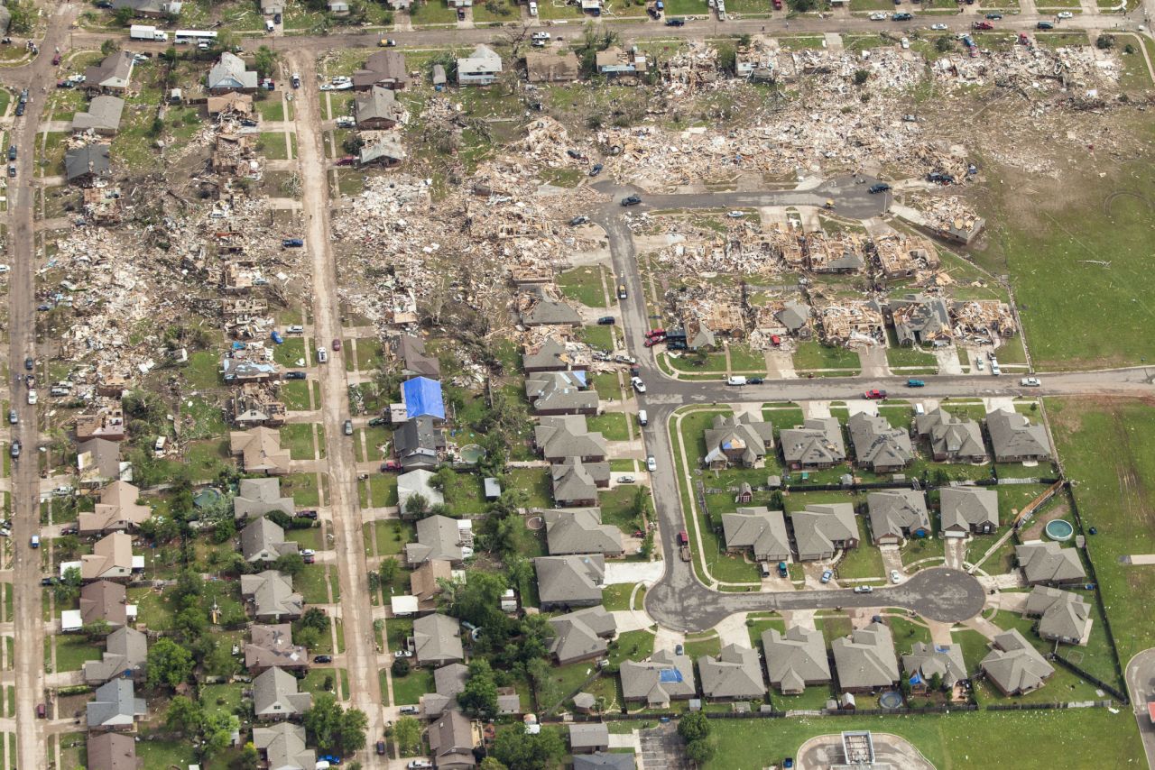
I’ve seen too many people killed and too much damage to not take severe thunderstorms seriously. My cousin’s home was destroyed in an EF-3 tornado in 2021 on a day that started out with only a level 1/5 marginal risk.
Posted on 2/26/23 at 9:34 pm to DVinBR
Thats a hell of a cap on that sounding.
Lowest 1 km is like all streamwise though.
Lowest 1 km is like all streamwise though.
Posted on 2/26/23 at 9:41 pm to Duke
quote:
Thats a hell of a cap on that sounding.
quote:
Duke

Posted on 2/26/23 at 10:05 pm to weadjust
quote:
Looks like there is a 70-85% chance of not severe weather
I see you’re a glass half full kind of guy
Posted on 2/27/23 at 10:18 am to DVinBR
SPC discussion this morning about Thursday into Friday:

Posted on 2/27/23 at 10:55 am to Duke
The GFS has some things to work out. Pretty much every sounding pulled is strongly capped, while at the same time Reflectivity shows a strong line of severe storms forming almost all at once. That doesn't really make sense.
If not for the storm mode issue, everything looks ripe for problems. Every sounding is a loaded gun, and you can pull PDS soundings pretty easily across the warm sector early in the event.
As it stands, this would be a late evening/overnight event yet again for most people, and early morning for Alabama and Georgia.
Posted on 2/27/23 at 11:53 am to LegendInMyMind
I have to drive to Memphis late Thursday afternoon so that guarantees a tornado outbreak
Always happens when I travel
Always happens when I travel

Posted on 2/27/23 at 12:03 pm to Roll Tide Ravens
People will always bitch on here because South LA rarely gets hit except for the occasional New Orleans tornado so it always seems overhyped. However we do have a lot of MS and AL posters and I think these threads are helpful. If you don't like the thread just don't open it, not that hard.
Posted on 2/27/23 at 12:04 pm to deltaland
quote:
I have to drive to Memphis late Thursday afternoon so that guarantees a tornado outbreak
With the current timing, you shouldn't have to deal with much of it if you leave in the evening. Right now it isn't getting to your area until around midnight. You'll probably have rain on the drive, but it doesn't look like much in the way of severe during that time right now. TN looks to be pretty well covered with rain for most of the day Thursday.
Posted on 2/27/23 at 12:09 pm to red sox fan 13
quote:
here because South LA rarely gets hit except for the occasional New Orleans tornado
Wut? LOL
Posted on 2/27/23 at 2:33 pm to red sox fan 13
quote:
People will always bitch on here because South LA rarely gets hit except for the occasional New Orleans tornado so it always seems overhyped. However we do have a lot of MS and AL posters and I think these threads are helpful. If you don't like the thread just don't open it, not that hard.
We have posters from everywhere on here. Last night's weather thread is a good example. Some jack leg commented that no one here cares about Oklahoma. By the time storms started rolling there were quite a few Oklahoma and Kansas folks posting with a few others who had local interests.
Weather threads seem to draw out the posters who think nothing exists beyond their doorstep and their tiny bubble. Those tend to be the same people who cry when the weather impacts them and some a-hole out in California tells them to move if they don't like it. Then, they'll say the same thing when Cali burns, and the cycle continues forever.

 Page 1 of 34

Popular
Back to top