- My Forums
- Tiger Rant
- LSU Recruiting
- SEC Rant
- Saints Talk
- Pelicans Talk
- More Sports Board
- Fantasy Sports
- Golf Board
- Soccer Board
- O-T Lounge
- Tech Board
- Home/Garden Board
- Outdoor Board
- Health/Fitness Board
- Movie/TV Board
- Book Board
- Music Board
- Political Talk
- Money Talk
- Fark Board
- Gaming Board
- Travel Board
- Food/Drink Board
- Ticket Exchange
- TD Help Board
Customize My Forums- View All Forums
- Show Left Links
- Topic Sort Options
- Trending Topics
- Recent Topics
- Active Topics
Started By
Message
 0
0

Posted on 3/31/22 at 3:33 pm to LegendInMyMind
quote:
NWS Survey Team confirms an EF-0 tornado just east of Cane Bayou south of U.S. 190.
***In a most unbelievable coincidence, the track of this tornado from Lake Pontchartrain to 190 is nearly identical to one last week. In fact, we found different tree damage in the same yard!***
and the winner of 'most unlucky start to storm season' award is... the person with this yard!!!!
Posted on 3/31/22 at 3:58 pm to rt3
@NWSJacksonMS
quote:
Two survey teams have found EF-1 damage in south Jackson (Hinds County), while another tornado found in south Forrest county has low-end EF-2 damage associated with it. Our survey teams are still in the field, so this data is preliminary!
Posted on 3/31/22 at 4:24 pm to Duke
So...Tornado Alley has shifted?
Posted on 3/31/22 at 4:31 pm to LegendInMyMind
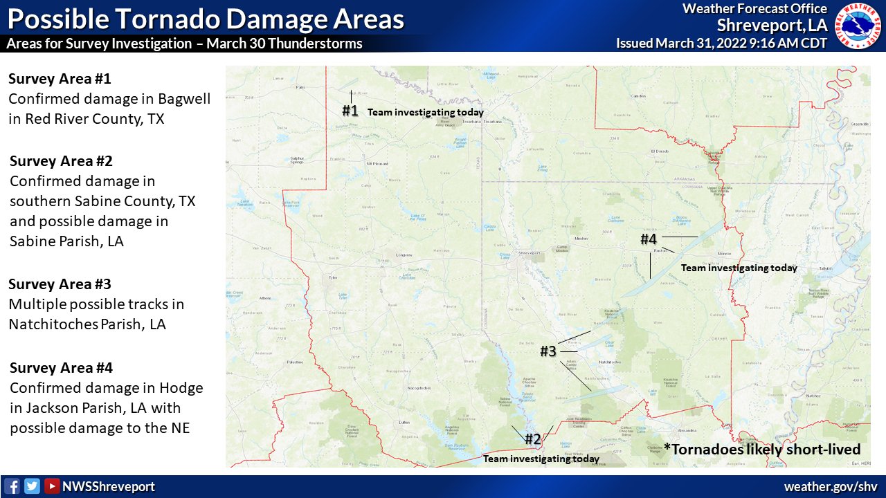
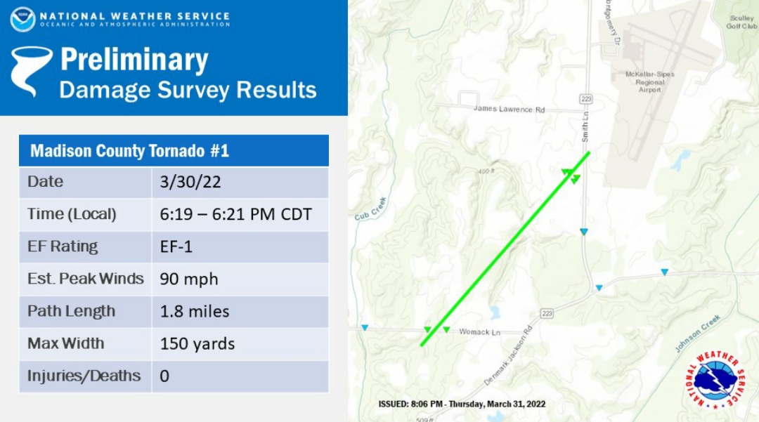
Shreveport's doing some work too
Posted on 3/31/22 at 5:04 pm to rt3
quote:
Public Information Statement
National Weather Service New Orleans LA 447 PM CDT Thu Mar 31 2022
...NWS Damage Survey for March 30th, 2022 Severe Weather... .Update...
Roseland Tornado has been added.
Roseland Tornado...
Rating: EF1
Estimated Peak Wind: 90 mph Path Length /statute/: 6.1 miles
Path Width /maximum/: 150 yards
Fatalities: 0
Injuries: 0
Start Date: 03/30/2022
Start Time: 06:12 PM CDT Start Location: 1 SSE Roseland / Tangipahoa Parish / LA
Start Lat/Lon: 30.7557 / -90.5106
End Date: 03/30/2022
End Time: 06:20 PM CDT
End Location: 4 W Wilmer / Tangipahoa Parish / LA
End Lat/Lon: 30.8178 / -90.4378
Survey Summary: A tornado touched down near Hwy 51 and Roseland Ave where several trees were found uprooted and numerous large branches snapped in a wooded area. The tornado was estimated to be moving northeast at 45 mph. It tracked across Holloway Rd where several trees were found uprooted or snapped. Dozens of trees were uprooted or large branches snapped a quarter-mile southeast of Hwy 10 along East Russell Town Rd. The most concentrated damage was surveyed along Hwy 10 near Harden Ln where numerous trees were uprooted and multiple homes sustained significant damage. One double-wide manufactured home was lifted off their foundation blocks and the roof torn. Windows were blown out on the north and east sides of the house. An outhouse on the property was destroyed and one of the wooden posts pierced through the front windshield of an SUV on the property. Another home sustained significant damage from a large uprooted tree that fell through the roof. There were multiple first-hand reports of debris being lofted as the tornado moved through. The tornado continued to track northeast but observed damage was more sporadic (and difficult to access on the ground) in the last 2 miles of the 6-mile long track, before lifting near Rt 1054 and Bryce Hyde Rd. Based on the damage survey, the tornado was rated an EF-1 with peak estimated winds of 90 mph.
Posted on 3/31/22 at 5:06 pm to LegendInMyMind
quote:
..Vancleave Tornado...
Rating: EF1
Estimated Peak Wind: 100 mph Path Length /statute/: 2.51 miles
Path Width /maximum/: 150 yards
Fatalities: 0
Injuries: 0
Start Date: 03/30/2022
Start Time: 09:47 PM CDT Start Location: 6 NNE St. Martin / Jackson County / MS Start Lat/Lon: 30.5204 / -88.8202
End Date: 03/30/2022
End Time: 09:51 PM CDT
End Location: 7 W Vancleave / Jackson County / MS
End Lat/Lon: 30.5461 / -88.7903
Survey Summary: A tornado touched down just southwest of the south end of Jim Ramsey Road moving northeast with minor damage on Fox Run Dr. The majority of the damage was on Fox Ridge Drive. Multiple manufactured homes had undercarriage and roof damage and were shifted off their foundation but none of the straps broke. One was split down the middle but after looking at it in detail, the part that split off was an addition to the home and was not anchored to the main home. This addition then pulled the rest of the home off with it. Uprooted and snapped trees were also noted in this area, many in a convergent pattern. The tornado ended near the intersection of Jim Ramsay Road and John Smith Road with minor roof damage to a well built home and damage to a nearby barn, along with two large trees uprooted.
Posted on 3/31/22 at 5:08 pm to LegendInMyMind
quote:
..State Line Road Tornado...
Rating: EF0
Start Date: 03/30/2022
Start Time: 10:30 PM CDT Start Location: 4 SW Tanner Williams / Jackson County / MS
Start Lat/Lon: 30.6894 / -88.4184
End Date: 03/30/2022
End Time: 10:34 PM CDT
End Location: 2 WSW Tanner Williams / Mobile County / AL
End Lat/Lon: 30.7131 / -88.4033
Survey Summary: A brief tornado touched down near Harry Pierce Road and moved northeast into Alabama and lifted just east of State Line Road. This was mostly due to tree damage and seeing a debris signature on radar. This did continue into NWS Mobile's area of responsibility and they will send another statement after they work on their points.
This post was edited on 3/31/22 at 5:10 pm
Posted on 3/31/22 at 5:12 pm to LegendInMyMind
And with the Cane Bayou tornado, that concludes the NWS New Orleans storm surveys of yesterday's storms. There were two EF1s and two EF0s. No injuries or fatalities.
Posted on 3/31/22 at 5:14 pm to rt3
@NWSJacksonMS
That's three for Jackson so far and four for NOLA. Birmingham has preliminarily confirmed three. They have said the Brent tornado produced "At least EF1 damage".
quote:
An additional preliminary rating of an EF-2 has been found in Noxubee County.
That's three for Jackson so far and four for NOLA. Birmingham has preliminarily confirmed three. They have said the Brent tornado produced "At least EF1 damage".
This post was edited on 3/31/22 at 5:21 pm
Posted on 3/31/22 at 5:20 pm to Cajunhawk81
quote:
So...Tornado Alley has shifted?
In some ways, yes. Mostly from a recent lack of tornadoes in traditional tornado alley. The south has always had tornadoes and I haven't seen great evidence there have been significantly more in recent years.
Posted on 3/31/22 at 5:51 pm to LegendInMyMind
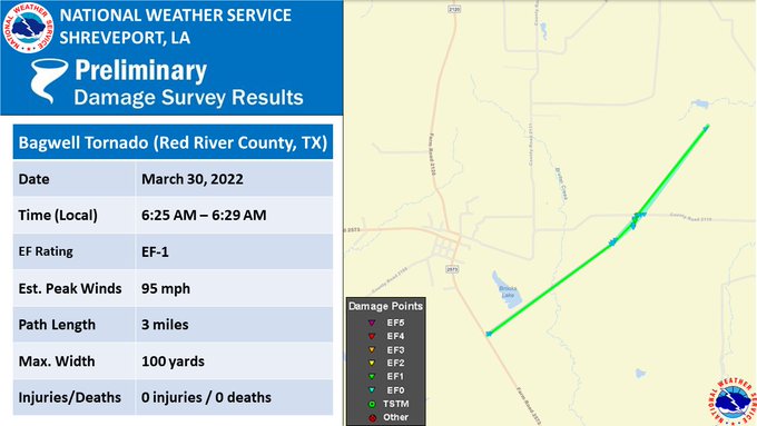
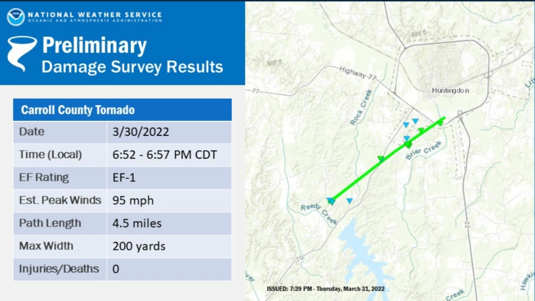
put Shreveport on the board for at least 1
quote:
NWS Shreveport @NWSShreveport
Our storm survey team confirmed today that an EF-1 tornado touched down yesterday morning near the Bagwell community in Red River County, TX. More storm surveys from yesterday's storms are still ongoing.
Posted on 3/31/22 at 6:05 pm to rt3
I'm glad next week's set up looks pretty sloppy. Northern energy doesn't look like it'll phase with the southern, leaving a pretty pedestrian shortwave coming over the south.
Might need to watch a little further east into eastern Alabama and Georgia, but looks pretty "meh" to this point.
I'll take it.
Might need to watch a little further east into eastern Alabama and Georgia, but looks pretty "meh" to this point.
I'll take it.
Posted on 3/31/22 at 6:06 pm to Duke
GFS hitting on 4-5" of rain across central AL into GA, most of it over a 6ish hour period.
Posted on 3/31/22 at 9:43 pm to rt3
@NWSMobile
They also mentioned in another tweet that the Greene County, MS tornado was upgraded to EF2.
quote:
Storm Survey Update: We confirmed *at least* 7 tornadoes so far. Surveys will continue tomorrow.
Preliminary tornado damage: EF1 in Choctaw County AL, EF0 in Perry County MS, at least EF1 in Greene County MS, at least 3 EF0s in Mobile County AL, EF0 in Baldwin County AL.
They also mentioned in another tweet that the Greene County, MS tornado was upgraded to EF2.
This post was edited on 3/31/22 at 9:45 pm
Posted on 3/31/22 at 9:51 pm to LegendInMyMind
Posted on 3/31/22 at 10:02 pm to LegendInMyMind
And the farthest North tornado may be NWS Paducah confirming an EF1 in White County, Illinois.

Posted on 3/31/22 at 10:35 pm to LegendInMyMind
Same time next week?

Posted on 3/31/22 at 10:46 pm to pioneerbasketball
quote:
Same time next week?
"Predictability too low"
Posted on 3/31/22 at 11:24 pm to Duke
Further West, projected to be pretty pedestrian in my neck of the woods.

 Page 90 of 92

Popular
Back to top