- My Forums
- Tiger Rant
- LSU Recruiting
- SEC Rant
- Saints Talk
- Pelicans Talk
- More Sports Board
- Fantasy Sports
- Golf Board
- Soccer Board
- O-T Lounge
- Tech Board
- Home/Garden Board
- Outdoor Board
- Health/Fitness Board
- Movie/TV Board
- Book Board
- Music Board
- Political Talk
- Money Talk
- Fark Board
- Gaming Board
- Travel Board
- Food/Drink Board
- Ticket Exchange
- TD Help Board
Customize My Forums- View All Forums
- Show Left Links
- Topic Sort Options
- Trending Topics
- Recent Topics
- Active Topics
Started By
Message
Tornado! Multi State Outbreak - New Tri-State Tornado
Posted on 2/28/17 at 11:00 am
Posted on 2/28/17 at 11:00 am
Large area under Tornado watches now:

Possibly another active day/night for tornadoes out there.
Most of the action looks to miss Louisiana this time around with the focus being from Arkansas up towards Ohio:
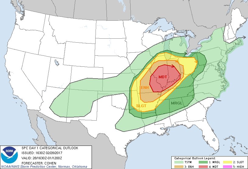
Pretty large 15% TOR hatch area:

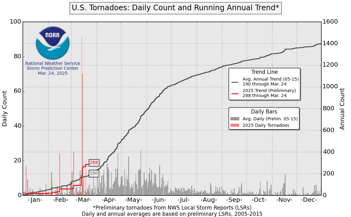
The 185 tornadoes has 2017 off to a fast start, esp. compared to the last couple of years:
Possibly another active day/night for tornadoes out there.
Most of the action looks to miss Louisiana this time around with the focus being from Arkansas up towards Ohio:
Pretty large 15% TOR hatch area:
The 185 tornadoes has 2017 off to a fast start, esp. compared to the last couple of years:
This post was edited on 2/28/17 at 10:45 pm
 8
8

Posted on 2/28/17 at 11:10 am to rds dc
It's been so warm over the east, it's not too surprising tornados are off to a fast start.
80 degrees on Mardi Gras just feels wrong.
80 degrees on Mardi Gras just feels wrong.
Posted on 2/28/17 at 11:20 am to Duke
quote:
It's been so warm over the east, it's not too surprising tornados are off to a fast start.
80 degrees on Mardi Gras just feels wrong.
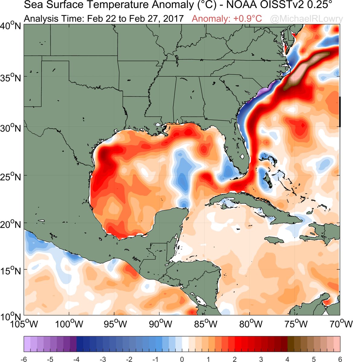
The warm winter has resulted in a record warm Gulf and that will juice up svr wx season and have implications for hurricane season:
Posted on 2/28/17 at 11:38 am to rds dc
Yeah, more worried about March-May than Hurricanes just yet.
We've had a juiced gulf for a couple of years, but shear has been the ruling regime. Really hope it stays that way. It feels like the Gulf South has dodged some bullets over the past few years. Warm waters but a hostile atmosphere.
We're kinda "overdue" for a major on the gulf coast.
We've had a juiced gulf for a couple of years, but shear has been the ruling regime. Really hope it stays that way. It feels like the Gulf South has dodged some bullets over the past few years. Warm waters but a hostile atmosphere.
We're kinda "overdue" for a major on the gulf coast.
Posted on 2/28/17 at 12:18 pm to Duke
Yeah, it's looking like a more subdued hurricane season

Posted on 2/28/17 at 12:47 pm to GEAUXmedic
A 15% hatched tornado risk area is quite impressive for late February, in that region.
Posted on 2/28/17 at 12:56 pm to Roll Tide Ravens
Significant Tornado Parameter off of the HRRR maxes out over a large area.


This post was edited on 2/28/17 at 12:57 pm
Posted on 2/28/17 at 1:35 pm to Roll Tide Ravens


Posted on 2/28/17 at 1:39 pm to Duke
I think we have seen that warm waters is only one of several components for an above average hurricane and a major GOM Storm.
Posted on 2/28/17 at 2:32 pm to GEAUXmedic
quote:
Yeah, it's looking like a more subdued hurricane season
That is my early hot take. A lot depends on how fast the atmosphere transitions to el nino conditions. SSTs are rapidly transitioning, esp. eastern zones like 1+2:


But the atmosphere continues to be low AAM and overall nina like:

I would expect the atmosphere to start the transition to el nino well before peak hurricane season. A top analog cluster returns an avg ACE of 64.
Posted on 2/28/17 at 3:45 pm to rds dc
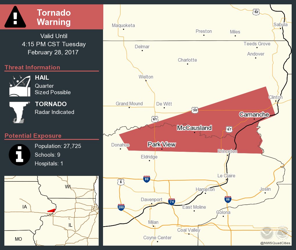
First Tor warning of the day:
Large area under Tornado Watch including numbers big cities:
Large area under Tornado Watch including numbers big cities:

Posted on 2/28/17 at 3:53 pm to rds dc
No Bill Paxton to help out this year
Posted on 2/28/17 at 4:18 pm to jeff5891
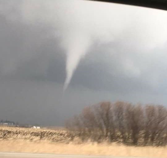
Small one from Iowa:
Reed on a big cell south of St. Louis:
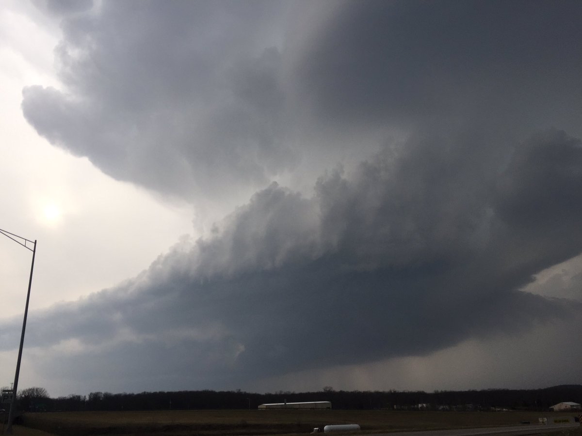
Reed on a big cell south of St. Louis:
This post was edited on 2/28/17 at 4:29 pm
Posted on 2/28/17 at 4:34 pm to rds dc
Probably nothing good going on with this...


Posted on 2/28/17 at 4:52 pm to rds dc
Reports of several tornadoes to the SW of Chicago. The Chicago radar is down for maintenance today.
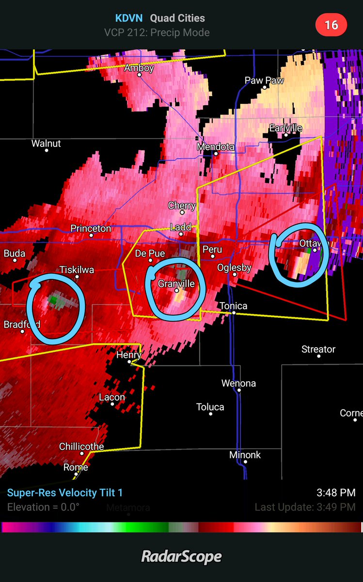
Bradford, IL just now:
Bradford, IL just now:
This post was edited on 2/28/17 at 5:03 pm

Posted on 2/28/17 at 4:56 pm to rds dc
quote:
the Chicago radar is down for maintenance today.
Damn Tornadoes have an agent on the inside. No way this is a coincidence.


Posted on 2/28/17 at 5:43 pm to rds dc
Yeah we're pretty concerned about the potential up here in Louisville, especially since it'll hit here in the middle of the night. Also concerned about the hail that we'll likely get. Doesn't look like we'll be getting much sleep tonight. 

Posted on 2/28/17 at 5:44 pm to rds dc
Given the location, I'd say the chances of a sharknado are disappointingly low.
Posted on 2/28/17 at 5:45 pm to rds dc
Second storm in Arkansas looks worry some especially since it's going to Mayflower/Maumelle area.

 Page 1 of 5

Popular
Back to top