- My Forums
- Tiger Rant
- LSU Recruiting
- SEC Rant
- Saints Talk
- Pelicans Talk
- More Sports Board
- Fantasy Sports
- Golf Board
- Soccer Board
- O-T Lounge
- Tech Board
- Home/Garden Board
- Outdoor Board
- Health/Fitness Board
- Movie/TV Board
- Book Board
- Music Board
- Political Talk
- Money Talk
- Fark Board
- Gaming Board
- Travel Board
- Food/Drink Board
- Ticket Exchange
- TD Help Board
Customize My Forums- View All Forums
- Show Left Links
- Topic Sort Options
- Trending Topics
- Recent Topics
- Active Topics
Started By
Message
re: Storm Tracking Thread: Post Tropical Storm Hermine
Posted on 8/24/16 at 4:12 pm to Roll Tide Ravens

Posted on 8/24/16 at 4:12 pm to Roll Tide Ravens
quote:
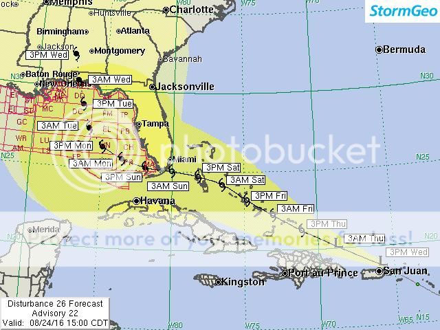
I understand, man. I just want to make sure no one believes this is a true forecast track. Apparently this company does work with some of the companies that do offshore drilling, so I don't know a ton about them. Seeing anyone putting up a forecast track/intensity cone threw up red flags for me.
That site is legit.
 0
0

Posted on 8/24/16 at 4:13 pm to GEAUXmedic
quote:
99L - Potential Gulf Threat
quote:
For those interested, these are the historical paths for storms passing 60 miles from the southern tip of Florida, coming from the Atlantic side.
Any way to narrow that down to August 21st-September 20th?


Posted on 8/24/16 at 4:14 pm to LSUfanNkaty


This post was edited on 8/24/16 at 4:16 pm
Posted on 8/24/16 at 4:14 pm to supernovasky


Posted on 8/24/16 at 4:16 pm to loogaroo
This bitch arse wave looks like its getting shredded on recent satellite images
Posted on 8/24/16 at 4:18 pm to loogaroo
A heads up with the map and the forecast cone going around - a lot of times, Oil and Gas companies want well advance warning that these things are coming this way. They'd rather err on the side of caution and thus have a lot more tolerance for wrong forecasts, hence bigger cones, cones established before a storm even forms, etc. TBH when a system does form and a cone comes out, it wouldn't surprise me if it were close to what this company is putting out. Thing is, the purpose of the company is to give WAY advanced, overly cautious warning. They have much higher tolerance for saying something will form and it not forming, than saying nothing will form and something does.
Posted on 8/24/16 at 4:21 pm to supernovasky
email from shell vp; to weather guy
"it's happening isn't it?"
"it's happening isn't it?"
Posted on 8/24/16 at 4:23 pm to LaBR4
Too soon to begin an evac thread, but is Amtrak in service from Nola to Houston thru BR?
Posted on 8/24/16 at 4:25 pm to Chad504boy


Posted on 8/24/16 at 4:28 pm to slackster
Yall saying we can hold off on running to Walmarks for battries and beanie weenies?
Posted on 8/24/16 at 4:28 pm to slackster
looks like its breaking up
Posted on 8/24/16 at 4:29 pm to LSUvegasbombed
What a pussy storm

Posted on 8/24/16 at 4:30 pm to slackster
Let's hope it gets shredded up. I live in Florida, and was hoping to squeak through this hurricane season.
Posted on 8/24/16 at 4:31 pm to fatboydave
We gotta wait for the center
This post was edited on 8/24/16 at 4:31 pm
Posted on 8/24/16 at 4:31 pm to slackster
It looks like its moving NW at the moment.

Posted on 8/24/16 at 4:32 pm to slackster
Based on the movement of the lower level winds it doesn't look like it's going to hit hispanola (moving WNW)

Posted on 8/24/16 at 4:34 pm to LSUvegasbombed
If it can survive into the Bahamas it'll be in business for rapid intensification. This will be its biggest test
Posted on 8/24/16 at 4:37 pm to LSUvegasbombed
Visible sat with wind gusts. It's a mess

This post was edited on 8/24/16 at 4:39 pm

Posted on 8/24/16 at 4:45 pm to GEAUXmedic
quote:
Visible sat with wind gusts. It's a mess
Come on, Hispaniola! We're all counting on you!

Posted on 8/24/16 at 4:45 pm to Pettifogger
quote:
Picture of a completely collapsed Starbucks on Twitter. It looks so odd because everything around it looks relatively unscathed.
It's okay, I'm sure there's another one close by.

 Page 52 of 175

Popular
Back to top