- My Forums
- Tiger Rant
- LSU Recruiting
- SEC Rant
- Saints Talk
- Pelicans Talk
- More Sports Board
- Fantasy Sports
- Golf Board
- Soccer Board
- O-T Lounge
- Tech Board
- Home/Garden Board
- Outdoor Board
- Health/Fitness Board
- Movie/TV Board
- Book Board
- Music Board
- Political Talk
- Money Talk
- Fark Board
- Gaming Board
- Travel Board
- Food/Drink Board
- Ticket Exchange
- TD Help Board
Customize My Forums- View All Forums
- Show Left Links
- Topic Sort Options
- Trending Topics
- Recent Topics
- Active Topics
Started By
Message
re: 6 or 7 Continents?
Posted on 11/16/15 at 6:28 pm to CelticDog

Posted on 11/16/15 at 6:28 pm to CelticDog
I noticed the Africa connection for the first time tonight? I had always thought it was completely seperated?
Serious question, have the maps changed in the past few decades? I've been out of school for a while and was never a big geography person but they appear much more defined than when I was in school
Serious question, have the maps changed in the past few decades? I've been out of school for a while and was never a big geography person but they appear much more defined than when I was in school
 3
3

Posted on 11/16/15 at 6:30 pm to PsychTiger
quote:
For example, the land mass between Mobile and New Orleans self identifies as "Mississippi", which while odd, is their right.
Posted on 11/16/15 at 6:34 pm to undecided
quote:
Serious question, have the maps changed in the past few decades? I've been out of school for a while and was never a big geography person but they appear much more defined than when I was in school
Most maps make the northern hemisphere much bigger than it is. Making Greenland appear as big as Africa. With good satellite images maps most likely are much better.
Posted on 11/16/15 at 6:35 pm to fr33manator
quote:
Europe and Asia divided by the Urals
The Sierra Nevada mts are bigger, can we say CA is on another continent? maybe as a first step to ceding them to Mexico?

Posted on 11/16/15 at 6:36 pm to gthog61
Perhaps it will just fall into the ocean so we can collect the insurance money and be done with it.
Alternative comment: It's not the size of your mountains, but how you use them ...
... to divide your continents.
Alternative comment: It's not the size of your mountains, but how you use them ...
... to divide your continents.
This post was edited on 11/16/15 at 6:38 pm
Posted on 11/16/15 at 6:38 pm to undecided
Posted on 11/16/15 at 6:39 pm to LucasP
quote:
The are seven continents.....and I've walked on every one of them. No. No you haven't.
As someone who has also walked on all seven continents why would you say that, even Antarctica is fairly simple to get to if you have the time, the cost is not unreasonable.
Posted on 11/16/15 at 6:40 pm to Nodust
Thanks, that's a good point. I'm sure satellite images have brought many improvements to our understanding of world geography
Posted on 11/16/15 at 6:59 pm to PsychTiger
quote:
someone from Land Mass has read

Posted on 11/16/15 at 7:01 pm to undecided
quote:really?
I noticed the Africa connection for the first time tonight?
Posted on 11/16/15 at 7:24 pm to tduecen
Yup  . I don't regularly look at world maps and what I remember from school was that it was seperated on all sides.

Posted on 11/16/15 at 7:38 pm to undecided
Europe is roughly separated from most of Asia by the Urals and Caucasus mountains. Culturally you could say roughly coincides with that demarcation as well.
But of course, there are no isthmuses or bodies of water to reinforce that.
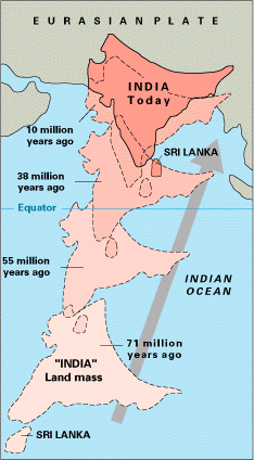
I think India should be its own continent. As of now it's considered a subcontinent.
But of course, there are no isthmuses or bodies of water to reinforce that.
I think India should be its own continent. As of now it's considered a subcontinent.
Posted on 11/16/15 at 7:40 pm to undecided
Africa connects to Asia with a couple narrow crossing on either side of the Sinai peninsula.
Posted on 11/16/15 at 8:10 pm to Swoopin
quote:It goes beyond culture. Europeans carry genes of Neanderthals. East Asians do not.
Culturally you could say roughly coincides with that demarcation as well.
Might explain the math and engineering differences we see today.
Posted on 11/16/15 at 9:35 pm to LSUgusto
Not all Europeans

Posted on 11/16/15 at 9:46 pm to undecided
Incontinent?
That's a pisser.
That's a pisser.
Posted on 11/16/15 at 9:55 pm to soccerfüt
In 20 years we'll be one continent,one people, one world. And isn't that why we voted for Obama anyway? # NWO
Posted on 11/16/15 at 11:03 pm to CelticDog
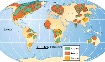
North America and South America have separate tectonic plates, and they are separated by a canal. The same can be said about Africa and the Middle East. Europe and Asia are separated by the Ural Mountain range, but share the same tectonic plate outside of India. India is more of a separate continent than is Europe, geologically speaking. It has its own tectonic plate and a much larger mountain range, the Himalayans, separating it from the rest of the Eurasian continent.

Posted on 11/17/15 at 12:30 am to kingbob
quote:
North America and South America have separate tectonic plates
This has always been my understanding how they really try and identify what constitutes a separate continent when looking at two connected land masses.
quote:
and they are separated by a canal.
It doesn't separate them geologically. Besides, if you make the argument based on a canal, what does a river do?
quote:
but share the same tectonic plate outside of India.
Hence the term "sub-continent."
Posted on 11/17/15 at 2:05 am to undecided
Pretty sure the other half of the world considers North and South America one continent.

 Page 2 of 3

Popular
Back to top