- My Forums
- Tiger Rant
- LSU Recruiting
- SEC Rant
- Saints Talk
- Pelicans Talk
- More Sports Board
- Fantasy Sports
- Golf Board
- Soccer Board
- O-T Lounge
- Tech Board
- Home/Garden Board
- Outdoor Board
- Health/Fitness Board
- Movie/TV Board
- Book Board
- Music Board
- Political Talk
- Money Talk
- Fark Board
- Gaming Board
- Travel Board
- Food/Drink Board
- Ticket Exchange
- TD Help Board
Customize My Forums- View All Forums
- Show Left Links
- Topic Sort Options
- Trending Topics
- Recent Topics
- Active Topics
Started By
Message
re: 2015 Season-Long Hurricane Thread - Watching Invest 96L
Posted on 7/30/15 at 7:40 pm to TDsngumbo
Posted on 7/30/15 at 7:40 pm to TDsngumbo
quote:
TROPICAL WEATHER OUTLOOK
NWS NATIONAL HURRICANE CENTER MIAMI FL
800 AM EDT WED JUL 29 2015
For the North Atlantic...Caribbean Sea and the Gulf of Mexico:
A tropical wave accompanied by a weak low pressure system is
producing an area of showers and thunderstorms a couple of hundred
miles southeast of the Cape Verde Islands. Environmental
conditions are expected to be at least marginally conducive for
some slow development through the weekend while the disturbance
moves westward at about 15 mph.
* Formation chance through 48 hours...low...near 0 percent
* Formation chance through 5 days...low...20 percent
It sure looks impressive today. It's the first of the cape verde season waves so let's be patient and see how the rest of the season unfolds. It's only July 29th and the peak is August 11th thru September 11th.
I'll let yall know if anything comes up. It only takes a storm 2-3 days for a storm to go from the cape verde islands to St. Maarten and the southeast caribbean. The last storm we had only gave us 18 hours notice. It would be our luck that we get a volcano about to blow and cause tsunami and hurricane hit at the same time.
 1
1

Posted on 7/30/15 at 8:12 pm to WeeWee
what yall think about this? looks like something may be developing right on the coast this weekend

This post was edited on 7/30/15 at 8:13 pm
Posted on 7/30/15 at 10:29 pm to chickman1313
quote:
what yall think about this?
That it is the Canadian...
I guess it does have some support from the CFSv2 ensembles and a few of the Euro ensembles but they all track it off towards Texas. The northern Gulf is probably the only place in the basin that has a chance of seeing something in the next couple days.


However, I would say that the image above is way to aggressive. At this point, an area of unsettled weather in the Gulf is likely but probably not much more than that.
Posted on 7/30/15 at 10:54 pm to rds dc
This has nothing to do with the tropics but a satellite captured a volcanic eruption this evening.

Posted on 7/30/15 at 10:55 pm to rds dc
that is cool as frick rds 
Posted on 7/30/15 at 11:11 pm to gaetti15
I have an uneasy feeling this is going to be a long arse thread before it is over

Posted on 7/31/15 at 9:44 am to rds dc
I'd argue it looked even more impressive on IR. I can't get the link but the tops got high really quick. The guys were pretty hyped about it when I got into work this morning.
and yeah that TC genesis is really bullish. I'm sticking to giving the cape verde wave zero chance... I'm pretty sure it's just an open trough now.
I haven't gotten a chance to look at the gulf very much today.
and yeah that TC genesis is really bullish. I'm sticking to giving the cape verde wave zero chance... I'm pretty sure it's just an open trough now.
I haven't gotten a chance to look at the gulf very much today.
Posted on 7/31/15 at 9:52 am to baytiger
holy balls our internal gfs is going nuts around 180-360 hours. I can't link it because it's an internal site but geez
here's the NOAA run... ours is higher res so it has all three lows as tropical cyclones

keep in mind this is almost 2 weeks out (and the first cyclone develops a week out) so a lot can change.. but this looks like something the Canadian model might put out, not the GFS
eta: as for the gulf... lots of rain from the system but nothing's forecasting tropical development. not even the GEM anymore.
here's the NOAA run... ours is higher res so it has all three lows as tropical cyclones
keep in mind this is almost 2 weeks out (and the first cyclone develops a week out) so a lot can change.. but this looks like something the Canadian model might put out, not the GFS
eta: as for the gulf... lots of rain from the system but nothing's forecasting tropical development. not even the GEM anymore.
This post was edited on 7/31/15 at 10:03 am

Posted on 7/31/15 at 9:55 am to baytiger

Posted on 7/31/15 at 9:57 am to rds dc
Where's that volcano RDS?
Posted on 7/31/15 at 9:58 am to s14suspense
Papua New Guinea
The volcano's name is Manam
The volcano's name is Manam
This post was edited on 7/31/15 at 10:04 am
Posted on 7/31/15 at 10:37 am to baytiger
quote:
I'd argue it looked even more impressive on IR. I can't get the link but the tops got high really quick. The guys were pretty hyped about it when I got into work this morning.
Yeah, it was way up there.
Here is the IR:

and true color:

Posted on 7/31/15 at 11:57 am to baytiger
12Z GFS is significantly less exciting but it still has a system forming off Cape Verde late next week.
Posted on 8/1/15 at 5:57 am to baytiger
quote:
12Z GFS is significantly less exciting but it still has a system forming off Cape Verde late next week.
It just won't give up on this and it could possible be right. IIRC, the GFS was too strong with a lot of waves coming off Africa last season and it appears to be doing that again this season. I haven't seen any papers on that (I haven't really looked either) but I would guess that someone is working that.
There looks like there could be a brief window up until about the 7th or 8th and then the suppressed phase of the KW plus the El Nino background state should work together to basically shut down the E. Atlantic. However, the GFS seems to think that is crazy talk and keeps churning out CV systems all the way to 384
The El Nino killing fields are already going strong, so it would probably take something like an Andrew track to get a significant system into the Gulf at this point.

Posted on 8/2/15 at 5:36 pm to rds dc
From Crown Weather
quote:
Sunday 8/2/2015 - 6:25 pm ET/5:25 pm CT: I am closely monitoring the northeastern Gulf of Mexico this evening where I think we have a organizing and strengthening low pressure system that looks to me to be a classifiable tropical cyclone. This includes it has a well defined closed circulation, barometric pressures have fallen to about 1008 millibars and there are wind gusts to 40 mph along the west coast of Florida and across the Big Bend area of Florida.
The latest information can be read at LINK -…/ . Additionally, I am monitoring things extremely closely and will have further updates this evening as conditions warrant.
Posted on 8/2/15 at 6:07 pm to Jim Rockford

Posted on 8/2/15 at 9:37 pm to Jim Rockford

and the Pacific keeps doing it

You can see the loop here - LINK
This post was edited on 8/3/15 at 1:19 pm
Posted on 8/3/15 at 1:21 pm to rds dc
Super Typhoon Soudelor going off in the Pacific
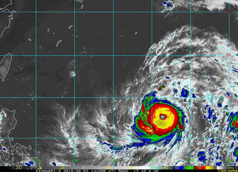
This post was edited on 8/3/15 at 1:22 pm

Posted on 8/3/15 at 9:53 pm to rds dc
Jsus those islands are going to get pummeled

Posted on 8/3/15 at 10:07 pm to rds dc
Holy shite I thought the Earth was round?

 Page 24 of 26

Popular
Back to top