- My Forums
- Tiger Rant
- LSU Recruiting
- SEC Rant
- Saints Talk
- Pelicans Talk
- More Sports Board
- Fantasy Sports
- Golf Board
- Soccer Board
- O-T Lounge
- Tech Board
- Home/Garden Board
- Outdoor Board
- Health/Fitness Board
- Movie/TV Board
- Book Board
- Music Board
- Political Talk
- Money Talk
- Fark Board
- Gaming Board
- Travel Board
- Food/Drink Board
- Ticket Exchange
- TD Help Board
Customize My Forums- View All Forums
- Show Left Links
- Topic Sort Options
- Trending Topics
- Recent Topics
- Active Topics
Started By
Message
re: Storm Tracking Thread: Post Tropical Storm Hermine
Posted on 8/23/16 at 11:41 pm to Zach Lee To Amp Hill
Posted on 8/23/16 at 11:41 pm to Zach Lee To Amp Hill
 0
0

Posted on 8/23/16 at 11:43 pm to Zach Lee To Amp Hill

Posted on 8/23/16 at 11:44 pm to slackster
Well crap
Posted on 8/23/16 at 11:47 pm to texag7
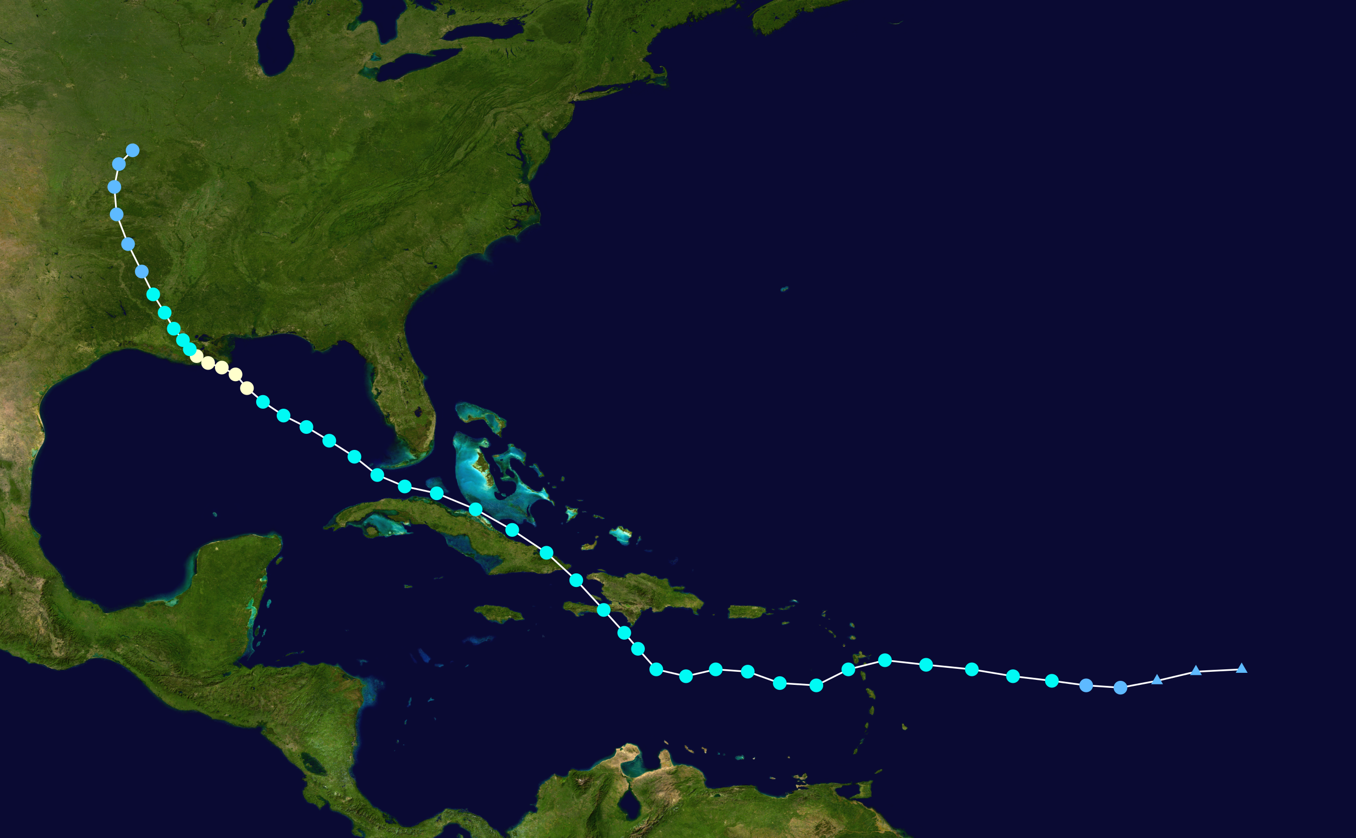
as of now it looks like someone from Central LA to the panhandle is under the gun but it also seems like most of these models keep it weak from what i can tell.
Posted on 8/23/16 at 11:58 pm to Zach Lee To Amp Hill
I just find it really hard to believe this thing not strengthening when it gets into that upper 80s Gulf water
Posted on 8/24/16 at 12:01 am to PhillyTiger90
quote:
I just find it really hard to believe this thing not strengthening when it gets into that upper 80s Gulf water
Agreed, but it happened with Isaac.
Posted on 8/24/16 at 12:02 am to PhillyTiger90
Biggest things from today, the best model in the world is getting to the range where it is very accurate and it is showing a system in the Gulf. All other guidance combined, including the Euro EPS, show that there is still a huge amount of uncertainty.
Posted on 8/24/16 at 12:05 am to slackster
quote:
Agreed, but it happened with Isaac.
Yep, takes more than warm water to make a storm.
Posted on 8/24/16 at 12:08 am to rds dc
So the GFS is taking this thing up the east coast at this point, but it gives us this monster on September 8th. 

ETA: It has actually predicted a major storm in this time frame for quite a few runs, but that far out is to be taken with a grain of salt ^2.
ETA: It has actually predicted a major storm in this time frame for quite a few runs, but that far out is to be taken with a grain of salt ^2.
This post was edited on 8/24/16 at 12:15 am

Posted on 8/24/16 at 12:15 am to slackster
GFS has gone wild
Posted on 8/24/16 at 12:33 am to rmnldr
quote:
GFS has gone wild
As dumb as it seems to have a model run 384 hours out, I always find myself a little upset that I can't run every model out for that long.
It can be comical at times, but the ECMWF also makes that wave an organized storm almost immediately off the coast of Africa. A potential Category 1 storm in the Cape Verde islands isn't a common occurrence by any means. Anyway, back to 99L.

Looking better organized by the hour.
Posted on 8/24/16 at 12:57 am to slackster
00Z HWRF has 99L going through the Florida Keys fixin to go into the GULF at the end of the run
Posted on 8/24/16 at 12:59 am to lsuman25
00z Euro so far:

Posted on 8/24/16 at 1:00 am to lsuman25
I'm starting to wonder if this thing doesn't end up with a center that is significantly farther south than the models were anticipating. Everything was based on the northern end, but if it is somewhere in the middle when it comes together, it could run into quite a few more land issues.
That may be an optimistic view though.
That may be an optimistic view though.
Posted on 8/24/16 at 1:04 am to GEAUXmedic
quote:
00z Euro so far:
Hopefully we get some recon flight data tomorrow and we can figure out where this circulation center is going to be.

Posted on 8/24/16 at 1:05 am to slackster
She's brewing.
Posted on 8/24/16 at 1:23 am to jcaz
EURO once again in Gulf still running
Posted on 8/24/16 at 1:26 am to slackster


Posted on 8/24/16 at 1:27 am to jcaz
As a SC fan in BR, this shite is headed right for us. Get your raincoats. I've been looking forward to going to Nashville for months and the same type of thing happened last time we played there. I hate Vanderbilt.
Posted on 8/24/16 at 1:30 am to CockyTime
At 144 hours in Central Gulf intensifying

 Page 25 of 175

Popular
Back to top