- My Forums
- Tiger Rant
- LSU Recruiting
- SEC Rant
- Saints Talk
- Pelicans Talk
- More Sports Board
- Fantasy Sports
- Golf Board
- Soccer Board
- O-T Lounge
- Tech Board
- Home/Garden Board
- Outdoor Board
- Health/Fitness Board
- Movie/TV Board
- Book Board
- Music Board
- Political Talk
- Money Talk
- Fark Board
- Gaming Board
- Travel Board
- Food/Drink Board
- Ticket Exchange
- TD Help Board
Customize My Forums- View All Forums
- Show Left Links
- Topic Sort Options
- Trending Topics
- Recent Topics
- Active Topics
Started By
Message
 1
1


Posted on 8/30/16 at 10:49 am to slackster
soooooooooo later tonight/early tomorrow morning we should get a diff cone possibly if it continues on its WNW flow? "possibly"....
I see this turning as well, just you never know if that Front doesn't get here in time to steer it.
I see this turning as well, just you never know if that Front doesn't get here in time to steer it.
Posted on 8/30/16 at 11:00 am to longhorn22
Sources continue to tell me they expect further west from model. Closer to Bama border.
Posted on 8/30/16 at 11:01 am to Rakim
this thing just wants to wreck my camping trip.

Posted on 8/30/16 at 11:01 am to Rakim
quote:
Sources

This post was edited on 8/30/16 at 11:02 am
Posted on 8/30/16 at 11:04 am to longhorn22
this shows the front in texas
eta: why doesn't it leave "FRONTS" on the right side checked? Scroll down a little, click fronts and you can see the front in Texas. Doesn't look like it's moving much???
eta: why doesn't it leave "FRONTS" on the right side checked? Scroll down a little, click fronts and you can see the front in Texas. Doesn't look like it's moving much???
This post was edited on 8/30/16 at 11:06 am
Posted on 8/30/16 at 11:08 am to tiger91
So, the High cutting through TX is the one that is supposed to push this storm East?

Posted on 8/30/16 at 11:09 am to tiger91
quote:
this shows the front in texas
That isn't the front. The front is the blue line traveling through Indiana, Ohio, West Virginia, and Virginia. It's supposed to swing down and create a trough to allow TD 9 to travel northeast. At least that's the way I understand it.
Posted on 8/30/16 at 11:10 am to tiger91
If you're just looking at fronts, here's an easier map to read

Posted on 8/30/16 at 11:12 am to medtiger
Noaa has added "supposed" to their guidance on the trough picking up TD9. We will still have to wait and see i think there is still a fair amount of error in the forecast tracks. I won't write this one off till it makes the hook to FL.
Posted on 8/30/16 at 11:16 am to medtiger
quote:
That isn't the front. The front is the blue line traveling through Indiana, Ohio, West Virginia, and Virginia. It's supposed to swing down and create a trough to allow TD 9 to travel northeast. At least that's the way I understand it.
OOPS. Thanks.
Posted on 8/30/16 at 11:17 am to burdman
Then what's the black line if the blue is the front?
Posted on 8/30/16 at 11:19 am to bayoudude
quote:
Noaa has added "supposed" to their guidance on the trough picking up TD9. We will still have to wait and see i think there is still a fair amount of error in the forecast tracks. I won't write this one off till it makes the hook to FL.
According to the models, any second now #9 will take off to the North. Yet further west along the TX coast everything is still moving straight west.
Posted on 8/30/16 at 11:21 am to bayoudude
Posted on 8/30/16 at 11:32 am to Rakim
quote:
Sources continue to tell me they expect further west from model. Closer to Bama border.
Ehh, 12z GFS is slightly west of the 6z run, but it is barely noticeable. Getting to the FL/AL border doesn't have much model support.
12z:

6z:

Posted on 8/30/16 at 11:40 am to slackster
Is it me or does it look like that storm is starting to turn north now? Maybe I'm just seeing things.

Posted on 8/30/16 at 11:41 am to tke857
quote:
this is why I dont trust the weather man
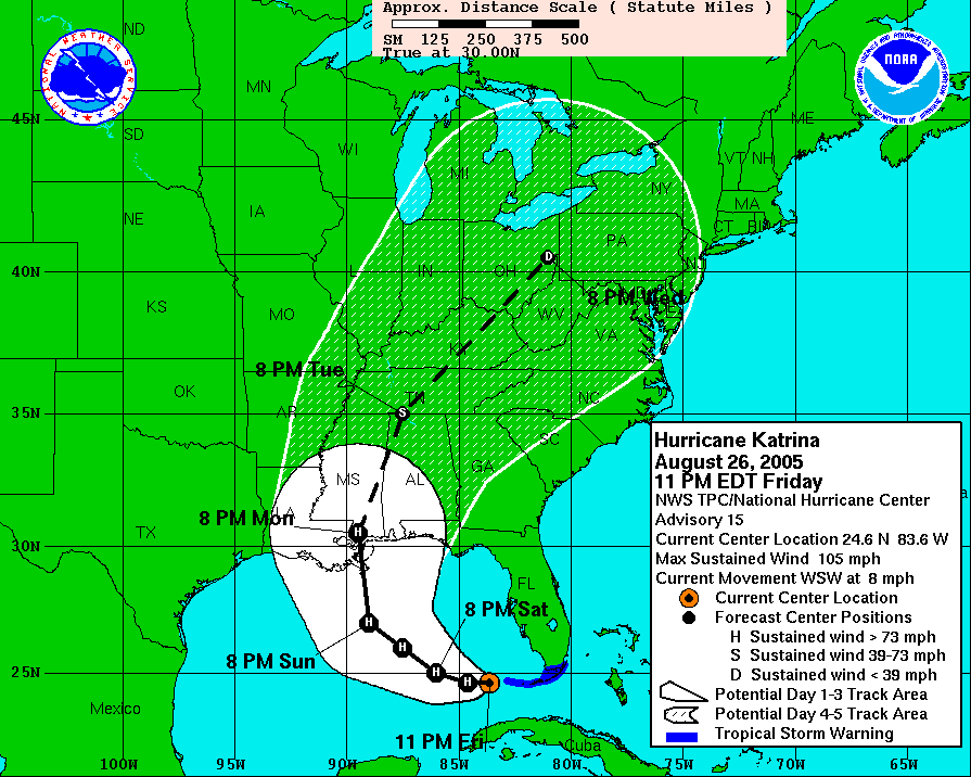
That is pretty stupid. Once in the Gulf, they nailed the track forecast of Katrina, thankfully.

Posted on 8/30/16 at 11:45 am to Sid in Lakeshore
In case it hasn't been linked already,
Golden Triangle Weather page. Lots of stuff there. Probably not great on a phone.
Golden Triangle Weather page. Lots of stuff there. Probably not great on a phone.
Posted on 8/30/16 at 11:48 am to Sid in Lakeshore
Posted on 8/30/16 at 11:50 am to deuce985
quote:
Is it me or does it look like that storm is starting to turn north now? Maybe I'm just seeing things.
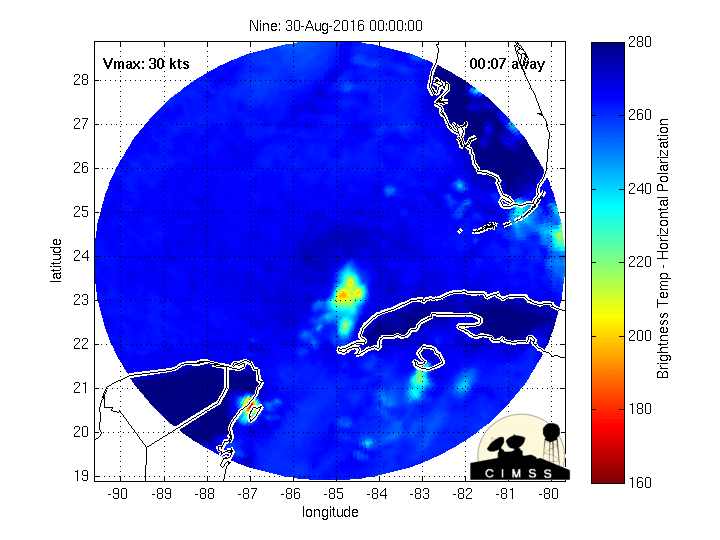
It does, and we should get a better idea once the visible satellite loop has a full light loop (not starting in the early morning, low light hours).
ETA: Can't really tell what is going on from IR imagery on a storm this poorly organized.
This post was edited on 8/30/16 at 11:51 am

 Page 145 of 175

Popular
Back to top