- My Forums
- Tiger Rant
- LSU Recruiting
- SEC Rant
- Saints Talk
- Pelicans Talk
- More Sports Board
- Fantasy Sports
- Golf Board
- Soccer Board
- O-T Lounge
- Tech Board
- Home/Garden Board
- Outdoor Board
- Health/Fitness Board
- Movie/TV Board
- Book Board
- Music Board
- Political Talk
- Money Talk
- Fark Board
- Gaming Board
- Travel Board
- Food/Drink Board
- Ticket Exchange
- TD Help Board
Customize My Forums- View All Forums
- Show Left Links
- Topic Sort Options
- Trending Topics
- Recent Topics
- Active Topics
Started By
Message
 1
1


Posted on 8/29/16 at 10:43 am to dukke v
quote:
Looks like it's going that way to me.....

Posted on 8/29/16 at 11:23 am to Nado Jenkins83
12z GFS is a tad NW on the track but basically ends up in the same general area. The trough is a bit faster through the NE and not as strong but still plenty deep enough to capture TD9. Like Bay posted earlier, this is getting to the point where things are looking pretty locked in.
Posted on 8/29/16 at 11:23 am to Nado Jenkins83
If this does hit Florida and the east coast I sure hope they don't get the rain we did a few weeks ago...
Posted on 8/29/16 at 11:39 am to Chad504boy
quote:
still looks like a non circulating thunder blob to me.
You've seen my boss?
Posted on 8/29/16 at 11:50 am to thejudge
The Canadian model is about as rock solid as you can get when it comes to showing something squirrelly (I'm on a flight with nothing much else to do right now)

Posted on 8/29/16 at 11:52 am to rds dc
quote:
The Canadian model is about as rock solid as you can get when it comes to showing something squirrelly (I'm on a flight with nothing much else to do right now)
what's squirrelly about it?
Posted on 8/29/16 at 11:54 am to rds dc
Looks like a lot of dry air in the northern portion of the circulation right now. Notice how any storms that fire out there collapse and spit out an outflow:


Posted on 8/29/16 at 12:03 pm to Chad504boy
quote:
what's squirrelly about it?
It shows another low pressure system developing basically over land on the northeast corner of Florida before TD 9 makes landfall later this week.
Posted on 8/29/16 at 12:04 pm to medtiger
Ok. And?
Posted on 8/29/16 at 12:05 pm to Fun Bunch
That's been forecasted for several days I thought

Posted on 8/29/16 at 12:16 pm to Chad504boy
quote:it'll turn anything it can into a hurricane
what's squirrelly about it?
Posted on 8/29/16 at 12:41 pm to baytiger
Bit of a westward trend on the last few GEFS runs, 12z from today:

Posted on 8/29/16 at 12:44 pm to rds dc
Posted on 8/29/16 at 12:51 pm to Jim Rockford
quote:
Jim Rockford
I wouldn't worry about that, as of now, the system still gets kicked out pretty easily.
Posted on 8/29/16 at 12:52 pm to rds dc
quote:
Storms starting to fire with TD8 and recon will be in there first. Could it be the H storm and TD9 be the I?
Probably not going to happen. The last three TD8 fixes have been progressively higher pressure...the most recent was 1013 just now.
Recon enroute to TD9 now
This post was edited on 8/29/16 at 12:53 pm
Posted on 8/29/16 at 12:56 pm to baytiger
Starting to think chances this thing can even get to a strong 2 is stupid low
Posted on 8/29/16 at 1:00 pm to rds dc
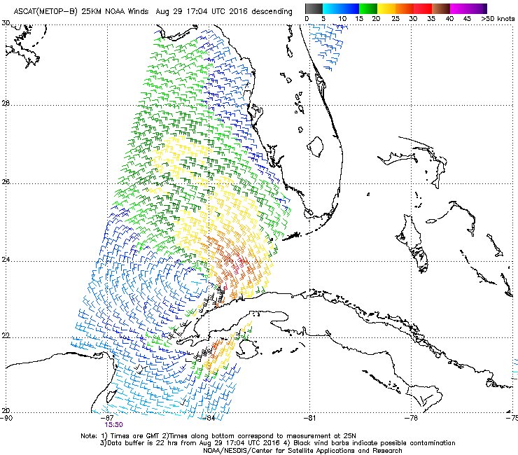
One of the better graphics i have seen concerning the center of circulation. Looks like we will have a tropical storm some time today IMO.
Pretty decent posting on jeff masters blog
Jeff Masters blog
ETA: Taken from the comments section
Pretty decent posting on jeff masters blog
Jeff Masters blog
ETA: Taken from the comments section
This post was edited on 8/29/16 at 1:01 pm

Posted on 8/29/16 at 1:02 pm to rds dc
it going to end up right at the MS/AL border IMO.. Almost every model has been adjusting it slightly west seemingly.

Posted on 8/29/16 at 1:04 pm to musick
quote:frick this
going to end up right at the MS/AL border IM

 Page 137 of 175

Back to top