- My Forums
- Tiger Rant
- LSU Recruiting
- SEC Rant
- Saints Talk
- Pelicans Talk
- More Sports Board
- Fantasy Sports
- Golf Board
- Soccer Board
- O-T Lounge
- Tech Board
- Home/Garden Board
- Outdoor Board
- Health/Fitness Board
- Movie/TV Board
- Book Board
- Music Board
- Political Talk
- Money Talk
- Fark Board
- Gaming Board
- Travel Board
- Food/Drink Board
- Ticket Exchange
- TD Help Board
Customize My Forums- View All Forums
- Show Left Links
- Topic Sort Options
- Trending Topics
- Recent Topics
- Active Topics
Started By
Message
 1
1


Posted on 8/29/16 at 7:46 am to tgrbaitn08
quote:
You nailed it
Let's slow down here. He said panhandle.

Posted on 8/29/16 at 7:47 am to TigerstuckinMS
Looks like it's going that way to me.....

Posted on 8/29/16 at 7:48 am to Paul Allen
quote:
Going out on a limb here and saying perhaps it evoked too many painful memories
So the O-T needs trigger warnings now?
Posted on 8/29/16 at 8:16 am to slackster
When do you think we'll know for sure a general area this thing is moving near? Tuesday? Wednesday? I ain't trusting these models until I see a NE turn on this damn thing. Speaking of which, how likely is this thing moves into the Atlantic again and then gets more powerful being another problem?
This post was edited on 8/29/16 at 8:21 am
Posted on 8/29/16 at 8:22 am to deuce985
I think we're gonna be okay
Posted on 8/29/16 at 8:25 am to GeauxxxTigers23
I trust your judgment...Have you stayed at a Holiday Inn Express recently? 

Posted on 8/29/16 at 8:25 am to GeauxxxTigers23
So if this thing becomes a Tropical storm, the streak ends right?

Posted on 8/29/16 at 8:28 am to GeauxxxTigers23
It is looking pretty good for Louisiana at the moment. The ridge is developing as planned over the eastern Rockies, and a 500 mb trough will dig ahead of it to provide the steering flow to get the system to turn northeast.
Additionally, shear is a bit stronger than anticipated, especially in the northern Gulf, which will hinder development a bit.
I can't blame you guys for waiting until the turn actually comes before you breathe easy though.
Additionally, shear is a bit stronger than anticipated, especially in the northern Gulf, which will hinder development a bit.
I can't blame you guys for waiting until the turn actually comes before you breathe easy though.
Posted on 8/29/16 at 8:30 am to DollaChoppa
quote:
So if this thing becomes a Tropical storm, the streak ends right?
Gotta become a hurricane. Colin was a TS in the gulf earlier this year.
I'm still not ruling it out, especially if it stays to the southerly bound of its forecast track.

Posted on 8/29/16 at 8:33 am to Roll Tide Ravens
Looks like it's still here to me..?
This post was edited on 8/29/16 at 8:34 am
Posted on 8/29/16 at 8:41 am to baytiger
quote:
Gotta become a hurricane. Colin was a TS in the gulf earlier this year.
Oh ok. Couldnt remember if it was just named storm or hurricane. Didnt pay attention to Colin at all
Posted on 8/29/16 at 8:42 am to Roll Tide Ravens
quote:It hasn't been deleted...
can anyone answer why my Hurricane Katrina "certain death; catastrophic damage warning thread got removed
Posted on 8/29/16 at 8:43 am to deuce985
quote:
When do you think we'll know for sure a general area this thing is moving near? Tuesday? Wednesday
Wednesday morning. May not know the exact landfall, but all the models suggest it should be moving NE towards FL by then. If it isn't NE by then, we'll know where else it's going by then.
quote:
Speaking of which, how likely is this thing moves into the Atlantic again and then gets more powerful being another problem?
The GFS suggests the outerbanks of the Carolinas could be subject to another landfall, but that's a long way out.
Fwiw, the HWRF is still suggesting a Category 1 landfall around the Tampa area.

~90 mph winds.
Posted on 8/29/16 at 8:50 am to baytiger
I have heard the streak mentiond as a major hurricane and just hurricane. I'm guessing since the last hurricane was a cat 3 one streak will at least still be in tact. Should it intensify
This post was edited on 8/29/16 at 8:52 am
Posted on 8/29/16 at 9:43 am to Catman88
GFNI can go straight to hell 
Posted on 8/29/16 at 9:53 am to JuiceTerry
11 AM EST update is out. western part of the cone shifting east again! 
Posted on 8/29/16 at 9:56 am to macatak911
Pretty good agreement across all models now on track. Convection looks pretty healthy this morning and recon might find a TS.
Posted on 8/29/16 at 10:02 am to rds dc
precipitation forecasts for day 3 and then 4-5, near bone dry from gulf shores on back to LA.
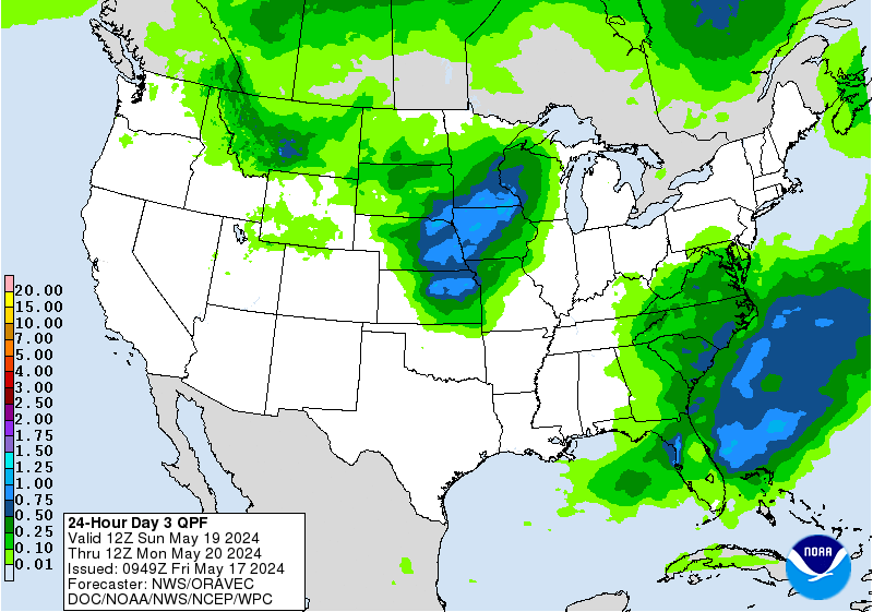
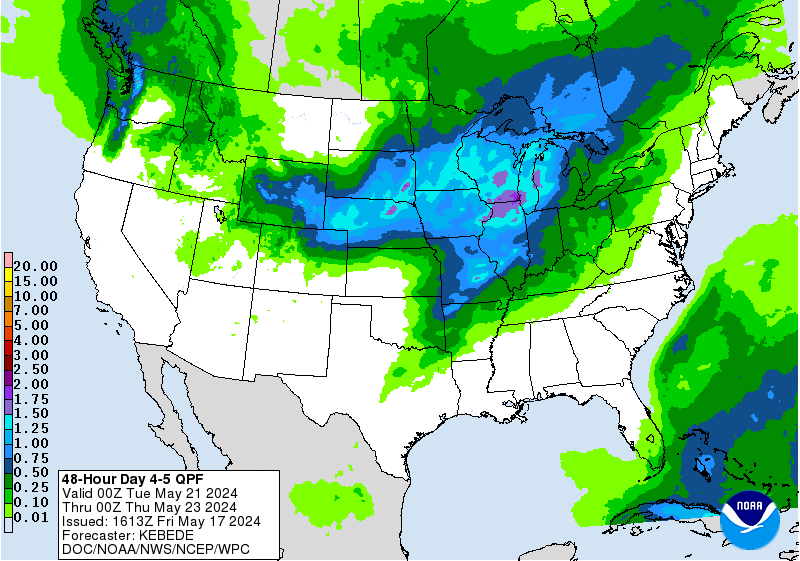
This post was edited on 8/29/16 at 10:03 am
Posted on 8/29/16 at 10:33 am to Chad504boy
Storms starting to fire with TD8 and recon will be in there first. Could it be the H storm and TD9 be the I?

 Page 136 of 175

Popular
Back to top