- My Forums
- Tiger Rant
- LSU Recruiting
- SEC Rant
- Saints Talk
- Pelicans Talk
- More Sports Board
- Fantasy Sports
- Golf Board
- Soccer Board
- O-T Lounge
- Tech Board
- Home/Garden Board
- Outdoor Board
- Health/Fitness Board
- Movie/TV Board
- Book Board
- Music Board
- Political Talk
- Money Talk
- Fark Board
- Gaming Board
- Travel Board
- Food/Drink Board
- Ticket Exchange
- TD Help Board
Customize My Forums- View All Forums
- Show Left Links
- Topic Sort Options
- Trending Topics
- Recent Topics
- Active Topics
Started By
Message

 1
1

Posted on 7/10/17 at 2:54 pm to ForeverLSU02
a 955mb low aiming right at the mouth of the MS? no thanks
think I'd have some family staying with me for some time if that even remotely started to come close to being possible
think I'd have some family staying with me for some time if that even remotely started to come close to being possible
Posted on 7/10/17 at 7:27 pm to rt3
Any updates?

Posted on 7/10/17 at 8:34 pm to fishfighter
quote:
Any updates?
Patience, my friend. this thing isn't expected for more than a week. Give it a day or two more.
Posted on 7/10/17 at 9:12 pm to East Coast Band
Looks like the GFS finally decided to join the rest of the models with the 18z run and give up on the crazy. It keeps the MDR wave weak and is a big step towards the other global models.
Of more interest in the near term is old TD4. The 12z Euro brings it into LA as a weak system but it produces a lot of rain.

The 00z tracks seem to favor the slow westward trek into the Gulf

The pulsing convection and numerous outflow boundaries from today indicate that the system is still dealing with a lot of dry air. It may have a chance once it reaches the Gulf but as of now everything points to it staying weak.
Still pulsing convection tonight.

Of more interest in the near term is old TD4. The 12z Euro brings it into LA as a weak system but it produces a lot of rain.
The 00z tracks seem to favor the slow westward trek into the Gulf
The pulsing convection and numerous outflow boundaries from today indicate that the system is still dealing with a lot of dry air. It may have a chance once it reaches the Gulf but as of now everything points to it staying weak.
Still pulsing convection tonight.
This post was edited on 7/10/17 at 10:14 pm
Posted on 7/10/17 at 10:42 pm to rds dc
quote:
Looks like the GFS finally decided to join the rest of the models with the 18z run and give up on the crazy.
so no more 955mb low coming straight up the mouth of the MS?
Posted on 7/11/17 at 5:55 am to rt3
Thanks RDS. 
Posted on 7/11/17 at 7:56 am to rds dc
Models have settled down and are now showing a more typical July pattern. There is still a small chance that old TD4 fires back up but things should be pretty calm for the next couple of weeks. During that time, the Euro, GFS and UKMet all get upgrades so maybe there will be less fantasy storms in the long range.

I posted the image above a few days back and it was showing a much more favorable Atlantic pattern. Now it has flipped and it may be early August before conditions across the Atlantic improve but that could change.
I posted the image above a few days back and it was showing a much more favorable Atlantic pattern. Now it has flipped and it may be early August before conditions across the Atlantic improve but that could change.
Posted on 7/13/17 at 11:44 pm to rds dc
00z is showing activity next weekend

Posted on 7/14/17 at 12:01 am to rds dc

This post was edited on 7/14/17 at 12:02 am
Posted on 7/14/17 at 12:12 am to texag7
That may be a couple runs now it's shown that, but I still wouldn't trust it at all that far out, especially when the only other model that agrees is the CMC.
Posted on 7/15/17 at 10:18 am to rds dc
The Atlantic looks to stay pretty calm for at least the next 10 days and probably all the way into early August.
The EPAC is cranking out storms and is already on F, Fernanda just went through a rapid intensification cycle.

The EPAC is cranking out storms and is already on F, Fernanda just went through a rapid intensification cycle.
Posted on 7/15/17 at 11:16 am to GEAUXmedic
quote:
That may be a couple runs now it's shown that, but I still wouldn't trust it at all that far out, especially when the only other model that agrees is the CMC.
It's time to abandon the GFS, I don't even look at it anymore. The GFS Para doesn't seem to have the phantom storm bias of the current GFS.
Posted on 7/15/17 at 10:15 pm to rds dc
Sun setting on EPAC system Fernanda

Posted on 7/15/17 at 11:15 pm to rds dc
Is this from what was going on last week? Or is this a new wave being formed?

Posted on 7/16/17 at 2:29 am to East Coast Band
I believe that's the same one. I figured we'd see it again
Posted on 7/16/17 at 7:43 am to East Coast Band
quote:
Is this from what was going on last week? Or is this a new wave being formed?
No, this is the next wave in line. The last one never developed and continued to race westward and is now in the WCAB

As of right now, this wave has no future, if it were to briefly develop into a named system. Shear in the Caribbean is forecast to be pretty stout.

Regardless, the NHC has tagged this as 95L.
This post was edited on 7/16/17 at 7:47 am
Posted on 7/17/17 at 2:12 pm to rds dc
Looking like we'll probably have TD 5 today.
Recon found closed, tight circulation.

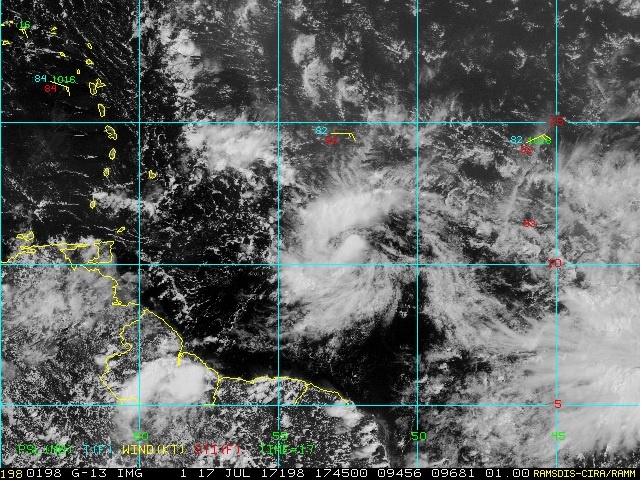
Recon found closed, tight circulation.
This post was edited on 7/17/17 at 2:16 pm
Posted on 7/17/17 at 2:36 pm to GEAUXmedic
Cantore may have the biggest hard on of his life.
Posted on 7/17/17 at 4:49 pm to biohzrd
officially have TS Don

 Page 6 of 9

Popular
Back to top