- My Forums
- Tiger Rant
- LSU Recruiting
- SEC Rant
- Saints Talk
- Pelicans Talk
- More Sports Board
- Fantasy Sports
- Golf Board
- Soccer Board
- O-T Lounge
- Tech Board
- Home/Garden Board
- Outdoor Board
- Health/Fitness Board
- Movie/TV Board
- Book Board
- Music Board
- Political Talk
- Money Talk
- Fark Board
- Gaming Board
- Travel Board
- Food/Drink Board
- Ticket Exchange
- TD Help Board
Customize My Forums- View All Forums
- Show Left Links
- Topic Sort Options
- Trending Topics
- Recent Topics
- Active Topics
Started By
Message
re: Storm Aftermath - Hurricane Matthew will be Retired
Posted on 9/24/16 at 1:45 pm to SohCahToa
Posted on 9/24/16 at 1:45 pm to SohCahToa
There is obviously something different about this one. Usually nobody even mentions a storm out this far other than maybe a sentence or two on a blog just saying it's something to watch for later.
With this thing 2 weeks out I'm almost certain a front will play a factor here
I'm really hoping we can get a cool front for opening weekend of deer season
With this thing 2 weeks out I'm almost certain a front will play a factor here
I'm really hoping we can get a cool front for opening weekend of deer season
 0
0

Posted on 9/24/16 at 1:53 pm to Ghost of Colby
quote:
I don't recall ever seeing a system maintain a straight line that passes just north of S. America or gets that close to middle/lower C. America. Does this only happen late in the season?
I don't think Aruba has been hit by a Hurricane in recorded history.
Posted on 9/24/16 at 2:00 pm to jimbeam
That's what they told us in 2005, Katrinas and Ritas would happen every year.
Posted on 9/24/16 at 2:12 pm to rds dc
That's not a good look at D10 on the 12z Euro

Posted on 9/24/16 at 3:50 pm to rds dc
Ok but based on that why would it turn and come north?

Posted on 9/24/16 at 3:52 pm to FelicianaTigerfan
It would curve north because of the curvature of the earth.
Posted on 9/24/16 at 4:30 pm to FelicianaTigerfan
Well, we don't know how it ends on the Euro run because the Euro does not go beyond that. However, looking at the map I see a trough coming through the Midwest. That can create the opening for it to start heading poleward. Timing is everything. If that trough gets clear off the East coast quickly then it opens up for this to head N then NE and probably into Florida. If it is a slow move or doesn't dig very far south then it may be a more gradual NW to N turn which is worrisome for us in Louisiana.
Posted on 9/24/16 at 4:50 pm to BigB0882
Thanks. Hard for someone that knows so little about it as I do to understand troughs and ridges. Some push it some pull it I guess
Posted on 9/24/16 at 4:58 pm to SohCahToa
quote:
Its pretty crazy how much everything is in agreement for being so far out time-wise. That's the thing that worries me.
Glad that I am no longer living in the caribbean.
Posted on 9/24/16 at 5:09 pm to rds dc
An interesting historical fact is that since 1851 a hurricane has not made landfall in Louisiana, Mississippi, Alabama, or Texas between October 5 and October 11. Here are the landfalls by date:
Sep. 27 - 1901
Sep. 28 - None
Sep. 29 - 1915, 1917, 1998
Sep. 30 - None
Oct. 1 - None
Oct. 2 - 1860, 1867, 1893
Oct. 3 - 1964, 2002
Oct. 4 - 1867, 1949, 1995
Oct. 5 - Oct. 11 - None
Oct. 12 - 1886
Oct. 13 - None
Oct. 14 - None
Oct. 15 - None
Oct. 16 - 1912, 1923, 1989
That's about 1 every 14 years between Oct. 2 and Oct. 16. And the last one was Lili in 2002 - 14 years ago. Based on climatology, the potential is there.
This potential system would most likely be between Oct. 7 and Oct. 9.
LINK
This post was edited on 9/24/16 at 5:17 pm
Posted on 9/24/16 at 5:23 pm to rds dc
Another dud of a season.. everyone it was fun with no major damage or storms to worry about.
Posted on 9/24/16 at 8:51 pm to moffettduck
NHC up to 70% chance of development:

Posted on 9/24/16 at 9:10 pm to rds dc
Keep it up. I follow the underground blog, but it is nice to have another outlet.
Posted on 9/24/16 at 9:54 pm to BigB0882
quote:
Well, we don't know how it ends on the Euro run because the Euro does not go beyond that. However, looking at the map I see a trough coming through the Midwest. That can create the opening for it to start heading poleward. Timing is everything. If that trough gets clear off the East coast quickly then it opens up for this to head N then NE and probably into Florida. If it is a slow move or doesn't dig very far south then it may be a more gradual NW to N turn which is worrisome for us in Louisiana.
That is basically it. Also, it is modeled to be so far south that a weaker trough might miss it allowing it to move into Central America. This time of year is always tough for the models to handle but the timing of troughs gets to be easier to pin down as we move towards October but the strength can still be tricky. The 12z Euro EPS is pretty much totally on board as well:

The EPS and control run go out to 15 days. The control is into Mexico and the EPS members are pretty evenly split with about 1/3 curving out east of Florida, 1/3 somewhere in the Gulf and 1/3 into Central America.
The trough is also pretty pronounced on the 12z Euro EPS:


Posted on 9/24/16 at 11:54 pm to rds dc


Posted on 9/25/16 at 12:23 am to purplepylon
898 and 924 mb? 
Posted on 9/25/16 at 12:26 am to purplepylon
Posted on 9/25/16 at 12:44 am to purplepylon
The storm surge with that strength and slow forward speed would be incredible.
60 hours to travel from Cuba to the FL panhandle. That's less than 10 mph.
60 hours to travel from Cuba to the FL panhandle. That's less than 10 mph.
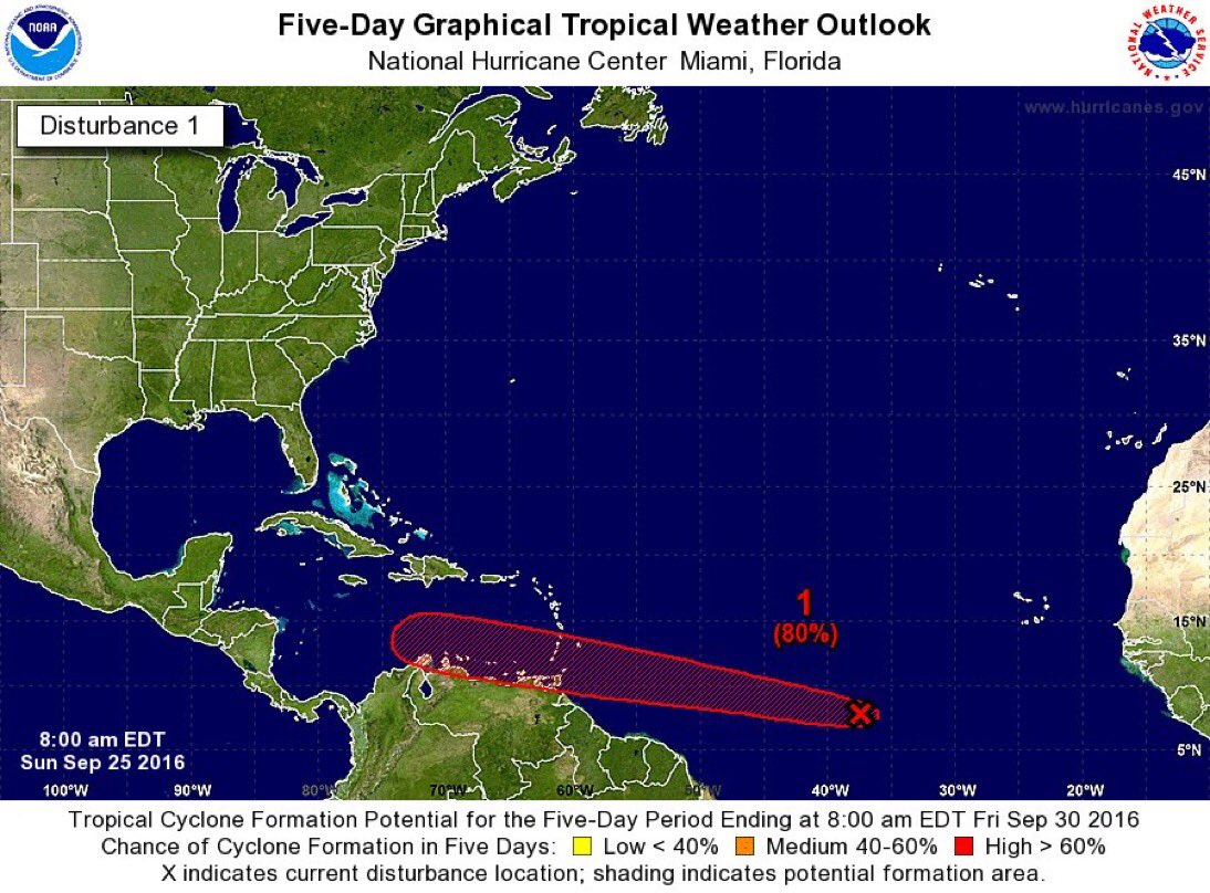
Posted on 9/25/16 at 7:41 am to NorthEndZone
NHC up to 80%
Models are now running for 97L:

Models are now running for 97L:
This post was edited on 9/25/16 at 7:46 am

Posted on 9/25/16 at 7:48 am to rds dc
Well...that's a pretty tight consensus

 Page 4 of 181

Back to top