- My Forums
- Tiger Rant
- LSU Recruiting
- SEC Rant
- Saints Talk
- Pelicans Talk
- More Sports Board
- Fantasy Sports
- Golf Board
- Soccer Board
- O-T Lounge
- Tech Board
- Home/Garden Board
- Outdoor Board
- Health/Fitness Board
- Movie/TV Board
- Book Board
- Music Board
- Political Talk
- Money Talk
- Fark Board
- Gaming Board
- Travel Board
- Food/Drink Board
- Ticket Exchange
- TD Help Board
Customize My Forums- View All Forums
- Show Left Links
- Topic Sort Options
- Trending Topics
- Recent Topics
- Active Topics
Started By
Message
Tornado! Large PDS Watch Issued for Portions of LA & MS
Posted on 11/25/22 at 6:11 pm
Posted on 11/25/22 at 6:11 pm


This post was edited on 11/29/22 at 1:22 pm
 26
26

Posted on 11/25/22 at 6:14 pm to rds dc
I was looking for this thread earlier 
Posted on 11/25/22 at 6:14 pm to rds dc
Dammit. I hadn't started my poll on who would be first to post it.

Posted on 11/25/22 at 6:16 pm to rds dc
We don't need this
Posted on 11/25/22 at 6:16 pm to rds dc
Its about to be winter, turn the shear machine up to 11.
Yeah, looks of a potent setup.
Yeah, looks of a potent setup.
Posted on 11/25/22 at 6:17 pm to rds dc
Yoda speaks

Posted on 11/25/22 at 6:18 pm to rds dc
this is going to sneak up on people too
Posted on 11/25/22 at 6:18 pm to rds dc
Cliffs? I know a lot of shite but I didn’t study meteorology. Shocker I know!
Posted on 11/25/22 at 6:19 pm to rds dc
I think Jay grymes mentioned this last night for potential severe weather on Tuesday

Posted on 11/25/22 at 6:29 pm to rds dc
I gotta go get milk

Posted on 11/25/22 at 6:31 pm to rds dc
:ohno:
Posted on 11/25/22 at 7:00 pm to rds dc
quote:
the area delineated may continue to shift some in the coming days, depending on trends in system
Are we talking minor shifts or could SELA end up in the orange?
Posted on 11/25/22 at 7:06 pm to rds dc
Great, I guess I’ll have to wait until late Feb. to mow the grass.

Posted on 11/25/22 at 7:09 pm to rds dc


Posted on 11/25/22 at 9:13 pm to rds dc
quote:
Furthermore, a corridor of enhanced severe potential
appears likely within the broader risk area across the ArkLaMiss
vicinity.
Well, shite. And it, for now, looks like an overnight scenario where I am.
Posted on 11/25/22 at 9:20 pm to rds dc

This post was edited on 11/25/22 at 9:22 pm
Posted on 11/26/22 at 1:05 pm to rds dc
Looks like a potential BMF
Posted on 11/26/22 at 1:30 pm to rds dc
No snow no care during the winter.
Posted on 11/26/22 at 1:46 pm to rds dc
Great. The day I’m supposed to fly home from offshore for vacajun
Posted on 11/27/22 at 11:47 am to rds dc
SPC is specifically mentioning the possibility of a tornado outbreak.
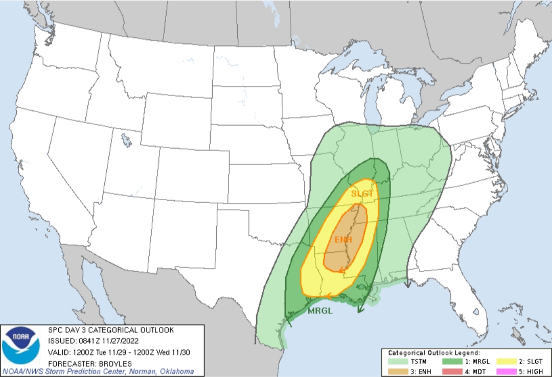
Day 3 Convective Outlook CORR 1 NWS Storm Prediction Center Norman OK
0241 AM CST Sun Nov 27 2022 Valid 291200Z - 301200Z
...THERE IS AN ENHANCED RISK OF SEVERE THUNDERSTORMS ACROSS PARTS OF THE LOWER TO MID MISSISSIPPI VALLEY... CORRECTED FOR WORDING
...SUMMARY...
Severe thunderstorms with wind damage and tornadoes, along with some hail, will be possible from the Sabine River Valley and lower Mississippi Valley north-northeastward into the mid Mississippi Valley on Tuesday. A significant severe-weather event will be likely across parts of the region.
...Lower to Mid Mississippi Valley/Sabine River Valley/Eastern Ozarks...
A highly progressive upper-level trough will move quickly into the southern and central Rockies on Tuesday. Ahead of the system, a broad 40 to 60 knot low-level jet will transport low-level moisture northward across east Texas and the lower Mississippi Valley, where surface dewpoints should reach the lower to mid 60s by midday. In response to moisture advection and surface heating, moderate instability is forecast to develop by early afternoon across much of east Texas and Louisiana. Isolated to scattered convective initiation will be possible in the early afternoon from near the instability axis eastward across the lower Mississippi Valley. A severe threat will be possible with this activity.
Moisture will continue to advect northward into the eastern Ozarks and mid Mississippi Valley during the late afternoon and early evening. This will set up a broad corridor of moderate instability across much of the lower to mid Mississippi Valley. As the upper-level trough approaches from the west, the low-level jet is expected to strengthen into the 50 to 70 knot range by early evening. This combined with increasing deep-layer shear, associated with an approaching southern Plains mid-level jet, will make conditions very favorable for severe thunderstorms across the lower to mid Mississippi Valley. NAM forecast soundings along the axis of strongest instability, from northeast Louisiana into eastern Arkansas, by 03Z Wednesday have MLCAPE in the 1500 to 2000 J/kg range, with 0-6 km shear in the 60 to 70 knot range. This combined with a long and looped hodographs, with 0-3 km storm-relative helicities in the 400 to 500 m2/s2 range, will be favorable for supercells and tornadoes. A few strong tornadoes will be possible with the more dominant supercells that remain discrete.[b/] The most favorable area for strong tornadoes may develop along the western edge of the low-level jet, as is forecast by the ECMWF, from eastern Arkansas into northwest Mississippi and western Tennessee. [b]A tornado outbreak will be possible across parts of the lower to mid Mississippi Valley, if the current forecast parameters, such as instability, deep-layer shear and low-level shear remain at current forecast levels.
In addition to the tornado threat, the potential for wind damage will likely increase during the evening as storm coverage and the chance for cell interactions increase. Mid-level lapse rates are also expected to be steep, which should support a hail threat with the more intense cells. The extent of moisture return will determine how far north-northeast the severe threat develops. At this time, it appears that at least some severe threat will be possible during the evening and overnight period as far north as southern Illinois and southwest Indiana. A categorical upgrade will be possible in later outlooks. ..Broyles.. 11/27/2022

 Page 1 of 2

Popular
Back to top