- My Forums
- Tiger Rant
- LSU Recruiting
- SEC Rant
- Saints Talk
- Pelicans Talk
- More Sports Board
- Fantasy Sports
- Golf Board
- Soccer Board
- O-T Lounge
- Tech Board
- Home/Garden Board
- Outdoor Board
- Health/Fitness Board
- Movie/TV Board
- Book Board
- Music Board
- Political Talk
- Money Talk
- Fark Board
- Gaming Board
- Travel Board
- Food/Drink Board
- Ticket Exchange
- TD Help Board
Customize My Forums- View All Forums
- Show Left Links
- Topic Sort Options
- Trending Topics
- Recent Topics
- Active Topics
Started By
Message
re: How many of you baws went to the public meeting last night about the new bridge?
Posted on 4/26/22 at 10:43 am to HouseMom

Posted on 4/26/22 at 10:43 am to HouseMom
quote:
Please go work for the bridge morons.
I think most of this is common sense, but the political considerations ruin it.
We have built bridges in Destrehan, Gramercy, and towards False River in the time since the interstate opened. None of these alleviate traffic, but help locals traverse the river.
Now we finally have money to build another bridge to actually help traffic and what are we doing - helping locals traverse the river, not substantially mitigating traffic flow through the middle of BR.
 2
2

Posted on 4/26/22 at 10:43 am to dewster
quote:
Oh FFS the media picks this idiot to quote?
Is she wrong? If the majority of the traffic is trying to get to I12, she has a point. No sense in building a bridge no one wants to take.
But I emphatically agree they need to start doing something. At some point the MRB, like the bridge in Lake Chuck is gonna have to be replaced. Nothing lasts forever! So I’d think they’d want to get started on an alternative crossing somewhere.
Posted on 4/26/22 at 10:48 am to Gauge
quote:
Although all 10 of the current bridge locations are pretty bad (there are better options that would also have less of an impact on river navigation as these 10 options)
Sounds like someone should let the Corps of Engineers, river pilots, and levee districts know - since they eliminated over half of the proposed bridge locations due to levee impacts or navigational issues.
Posted on 4/26/22 at 10:49 am to tigerinthebueche
quote:
If the majority of the traffic is trying to get to I12, she has a point.
It’s not.
Posted on 4/26/22 at 11:01 am to lostinbr
Gotcha.
Posted on 4/26/22 at 11:07 am to GetBackToWork
quote:
Now we finally have money to build another bridge
We do? I thought Governor Sloth planned to put aside half the money? Only half! And the other rats in the legislature refused to approve it cause they want to spend the money!
We should just ask The feds to build a loop and quit trying to do it ourselves. Another I-210 would probably be done easier than whatever we want to do ourselves. Maybe quicker too. But I guess our reps in Washington would have to do that and they’re probably too busy making sure we know how hard they’re working for us.
/s/

Posted on 4/26/22 at 11:22 am to Slippy
With none of the routes connecting the bridge to the interstate on either side, is it too far fetched to believe this is being pushed by real estate developers? There's thousands of undeveloped, non-flood prone sugar cane fields on the west side that could be turned into subdivisions and strip malls
Posted on 4/26/22 at 11:38 am to tigerinthebueche
quote:
Is she wrong? If the majority of the traffic is trying to get to I12, she has a point.
No, she's not but I think you misunderstood her or didn't read her actual quote.
quote:
Eits said lots of traffic on the current bridge near Port Allen, especially 18-wheelers, is trying to get to I-12 on the way east and those drivers want to avoid New Orleans.
The majority of semis are indeed going to 12, anyone can see this any afternoon as the majority of semis stick to the three inner lanes at the 10-12 split going east.
While a lot of smaller traffic goes the same direction, the real problem on 12 comes in with Essen and 10 being major routes for traffic onto 12 east, both being very near to each other and the traffic is compensated for with only short, temporary 4th lanes.
To add to this, a lot of traffic comes on at Airline as well and it's clover-leaf aspect means the outside lane becomes a massive clusterfrick as a high amount of traffic attempting to enter the interstate have to jockey with a high amount of traffic attempting to exit the interstate, all in a very small amount of space. Then just beyond that is the other entrance from Airline to the interstate (the northbound Airline traffic).
Where a bridge would be most effective is Option 1 (this is a bit farther south than the previous one, which was between Brusly and Addis).
The idea is that it should be the crossing point for a southern loop, where passthrough traffic could go to avoid coming into Baton Rouge altogether.

The yellow line is about where I would like to see the loop go with the current option. The purple line is where the previous northernmost choice was. Part of the key to this is having Hwy 30 four (ideally six) laned from the bridge up to LSU's campus in order to provide a large, new avenue for that population to pull a lot of that traffic from the center of the city as well. A loop like either of those would be the primary route any east-west traffic bound for New Orleans would take as well as open up more area for population growth BEFORE it gets there, create a new avenue for plant traffic (which takes it out of Baton Rouge) and adds only a few extra miles to any trip for those passing through the area entirely.
Posted on 4/26/22 at 11:43 am to lostinbr
Just because they said they eliminated a route because of "navigational issues," doesn't mean they were correct.
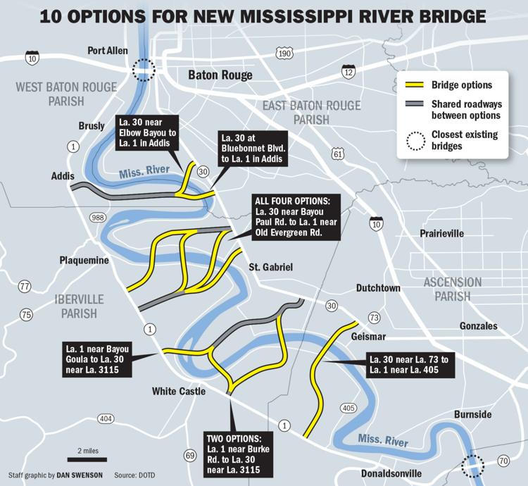
See the bridge location that I have added in red to the image below. This potential crossing location was removed from consideration because the entire width of the river in this location is a "no bridge pier zone." Meaning you can't put a support pier for a bridge IN THE RIVER in this location. However, you CAN put piers on the land just outside the boundaries of the river in this location. Also, the width of the river in this location just so happens to be significantly shorter here than in any other place that is under consideration. Specifically, the width of the river in this location is approximately 1,900 feet. Meaning, you could put the bridge piers on land only (i.e. not in the river at all -- thereby avoiding any impact to navigation whatsoever) and still have a main span distance of less than the other locations that are under consideration. This shorter bridge distance also means this location would be significantly cheaper to build than the other locations.
This location would also provide a more natural southeast to northwest direction of travel (as well as a shorter travel distance) for people trying to bypass Baton Rouge. This means more traffic would be diverted off of the current Horrace Wilkison bridge, and toll revenue generated by this new bridge would be much higher since more travelers would use the new bridge. So this location creates a viable Baton Rouge bypass for I-10 through travelers, while also still being close enough to Baton Rouge to provide a very attractive alternate route for local commuters who live in EBR/Ascension and work on the west side.
So this location is the cheapest to build, improves traffic around Baton Rouge the most, gets the most usage, and generates the most toll revenue. All with zero impact to river navigation. But instead, this location was eliminated simply because someone saw "no bridge pier zone" on a map and mistakenly figured "oh well, I guess we can't build a bridge there."
This post was edited on 4/26/22 at 11:52 am
Posted on 4/26/22 at 12:11 pm to Bard
Neither of the by-pass routes you drew in are viable.
They aren’t going to build a highway through major subdivisions
They aren’t going to build a highway through major subdivisions
Posted on 4/26/22 at 12:30 pm to doubleb
quote:
Neither of the by-pass routes you drew in are viable.
They aren’t going to build a highway through major subdivisions
They're perfectly viable if someone at DOTD has the balls to stand up to the NIMBYs. Their attitude is why we're in this mess in the first place.
Posted on 4/26/22 at 12:31 pm to Bard
quote:
he yellow line is about where I would like to see the loop go with the current option.
drop that yellow line just a little bit and you can go straight through/over the swamp. Boggles my little brain why this path for a bypass/bridge doesn't show up on any of the suggestions/options. I used the Google thingy to measure distance and it's only 23 miles total. It's about 21 miles taking I-10. Don't take a DOTD Traffic engineer to figure out people would gladly drive an extra 3 miles to save an hour in traffic. And an I-10 Interchange at/near Bluff Road has been discussed anyhow. Makes too much sense I suppose. The bend in the river is the only thing that I would imagine prevents a bridge going there. Build a tunnel maybe(It's pretty narrow there)?

This post was edited on 4/26/22 at 6:36 pm
Posted on 4/26/22 at 12:34 pm to tigerinthebueche
quote:gov sloth had the full match needed to build the bridge (20%). The second part is correct.
I thought Governor Sloth planned to put aside half the money? Only half! And the other rats in the legislature refused to approve it cause they want to spend the money!
Posted on 4/26/22 at 12:35 pm to GetBackToWork
quote:ie help locals get to plants.
Now we finally have money to build another bridge to actually help traffic and what are we doing - helping locals traverse the river, not substantially mitigating traffic flow through the middle of BR.
Posted on 4/26/22 at 12:39 pm to Gauge
quote:
So this location is the cheapest to build, improves traffic around Baton Rouge the most, gets the most usage, and generates the most toll revenue. All with zero impact to river navigation. But instead, this location was eliminated simply because someone saw "no bridge pier zone" on a map and mistakenly figured "oh well, I guess we can't build a bridge there."
Where are you getting this?
They absolutely evaluated locations with “no bridge pier zones” the entire width of the river. In fact, the maps on the project website specifically differentiate between “no bridge pier zone” and “no bridge zone (span length exceeded).”
The exact option you posted was considered by the project as alternative “C-7-IV.” You’re right that it was eliminated before the navigational impacts were evaluated, but not because of the no bridge pier zone. It was eliminated because the traffic models indicated it would have low average daily traffic. LINK
There’s a discussion to be had about whether you agree with the traffic models, but your characterization of why it was removed appears to be false as far as I can tell.

Posted on 4/26/22 at 12:40 pm to crewdepoo
To be fair, even if the new bridge is mainly used by locals, if it takes half the traffic off the current bridge, then what's the problem?

Posted on 4/26/22 at 12:42 pm to Slippy
Someone fill me in on what exactly they are proposing and why? What’s this bridge supposed to do?
Posted on 4/26/22 at 12:48 pm to mikelbr
quote:
drop that yellow line just a little bit and you can go straight through/over the swamp. Boggles my little brain why this path for a bypass/bridge doesn't show up on any of the suggestions/options. I used the Google thingy to measure distance and it's only 23 miles total.
Probably a combination of cost and (possibly) environmental impact.
That bridge location was evaluated but was eliminated in the round 1 screening. I agree that it would be a way more attractive location if it could be connected directly to I-10 through the swamp. The problem is that almost the entire portion from the bridge to I-10 in Ascension would need to be elevated, which adds a ton of cost and would be a pretty significant project on its own.
And again, that’s assuming it’s feasible from an environmental impact perspective (I don’t know the answer to that part).
Posted on 4/26/22 at 1:06 pm to Bard
quote:
They're perfectly viable if someone at DOTD has the balls to stand up to the NIMBYs. Their attitude is why we're in this mess in the first place.
You’re not putting a major highway through the middle of CCLA.
Posted on 4/26/22 at 1:16 pm to Bard
quote:
They're perfectly viable if someone at DOTD has the balls to stand up to the NIMBYs. Their attitude is why we're in this mess in the first place.
Actually the reason we are in such a mess is they built I-10 right through the middle of downtown BR, through University Lake, backyards all along the route and finally to the split where they continued to cut through neighborhoods until they crossed Airline Hwy.
Putting two major interstate junctions right in the middle of everything was terrible planning.
10 should have crossed the River south of LSU. But no, they wanted people to come Downtown. Look what that has given us.

 Page 4 of 6

Popular
Back to top