- My Forums
- Tiger Rant
- LSU Recruiting
- SEC Rant
- Saints Talk
- Pelicans Talk
- More Sports Board
- Fantasy Sports
- Golf Board
- Soccer Board
- O-T Lounge
- Tech Board
- Home/Garden Board
- Outdoor Board
- Health/Fitness Board
- Movie/TV Board
- Book Board
- Music Board
- Political Talk
- Money Talk
- Fark Board
- Gaming Board
- Travel Board
- Food/Drink Board
- Ticket Exchange
- TD Help Board
Customize My Forums- View All Forums
- Show Left Links
- Topic Sort Options
- Trending Topics
- Recent Topics
- Active Topics
Started By
Message
re: Let's Do It Again: Severe Threat 3/30 - Line of Severe Storms leaving SELA. AL in it now
Posted on 4/1/22 at 8:45 am to wfallstiger
Posted on 4/1/22 at 8:45 am to wfallstiger
Jackson confirmed six total yesterday, which doubled their initial report. Three of those were EF2s. Three injuries were reported with these.
@NWSJacksonMS
I mentioned back during the the event that I would hate to be on the survey teams after this event. They had a boatload of warnings and damage reports. It has to be a headache sorting that all out.
@NWSJacksonMS
quote:
(1/2) Storm survey teams found 6 tornadoes from the March 30th severe weather event. Three EF-2, two EF-1, and one EF-0 tornadoes were determined. One person was injured in South Jackson (Hinds Co.) and two people were injured in the Prairie Point (Noxubee Co.) tornadoes. LINK
I mentioned back during the the event that I would hate to be on the survey teams after this event. They had a boatload of warnings and damage reports. It has to be a headache sorting that all out.
 1
1

Posted on 4/1/22 at 8:47 am to LegendInMyMind
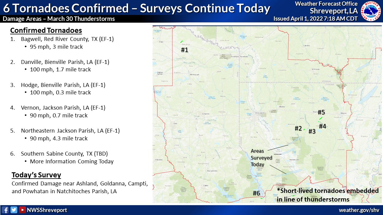
@NWSShreveport
quote:
6 tornadoes were confirmed so far from March 30th in our area. There were 5 EF-1s and another confirmed tornado with a rating still TBD. A survey team will be out again today surveying several damage locations in Natchitoches Parish, LA. LINK
Posted on 4/1/22 at 8:53 am to LegendInMyMind
This one is just for the downvote:
@NWSHuntsville
@NWSHuntsville
quote:
9:25pm Lauderdale Co Storm Survey Results:
Extensive straightline wind damage of 85-90 mph. Main swath of damage was around CR6/Highway 20 which extended north of Cloverdale.
#HUNwx
Posted on 4/1/22 at 8:56 am to LegendInMyMind
And a 15% Day 4,5, and 6 was added by SPC.
Posted on 4/1/22 at 9:08 am to LegendInMyMind
quote:
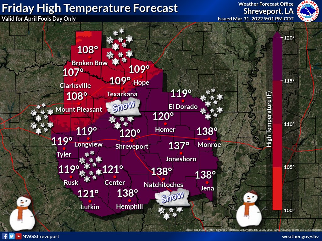
NWS Shreveport @NWSShreveport
High temperatures for today, April 1st 2022, will range from 108° to 138° across the region. These temps will be achieved fairly early in the day, as a intense cold front rushes through this afternoon bringing an enormous amount of snow to the area. #AprilFools #NotARealForecast
Posted on 4/1/22 at 9:10 am to LegendInMyMind
quote:
@NWSShreveportquote:
6 tornadoes were confirmed so far from March 30th in our area. There were 5 EF-1s and another confirmed tornado with a rating still TBD. A survey team will be out again today surveying several damage locations in Natchitoches Parish, LA. LINK
I got you with the map they tweeted out too
Posted on 4/1/22 at 9:12 am to rt3
quote:
I got you with the map they tweeted out too
Thanks. I really didn't want to upload/post all the graphics this morning.
Posted on 4/1/22 at 9:18 am to LegendInMyMind
kinda surprised Lake Charles hasn't had anything to report
Posted on 4/1/22 at 9:34 am to LegendInMyMind
quote:
And a 15% Day 4,5, and 6 was added by SPC.
*cusses in weather*
Posted on 4/1/22 at 9:38 am to Duke
quote:
*cusses in weather*
I'd like to be read into the lingo, please

Posted on 4/1/22 at 9:45 am to rt3
quote:El Niño is Spanish for The Niño. You’re welcome.
I'd like to be read into the lingo, please
Posted on 4/1/22 at 9:49 am to When in Rome

Posted on 4/1/22 at 9:52 am to Duke
So far the language for next week doesn’t sound too ominous due to only slight instability expected at this time. Hopefully it doesnt trend the wrong way
Posted on 4/1/22 at 12:36 pm to deltaland
@NWSBirmingham
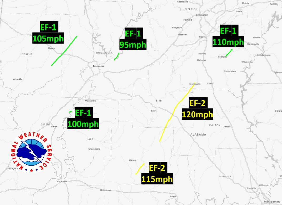
quote:
Surveys are ongoing at this moment. Here's where currently stand: 4 EF-1 tornadoes and 2 EF-2 tornadoes from March 30th. Yes, we expect more tracks to be added as we work through our list of additional damage locations in Hale, Greene, Sumter, Marengo, Dallas, and Lowndes. 1/3 LINK
Posted on 4/1/22 at 12:38 pm to LegendInMyMind
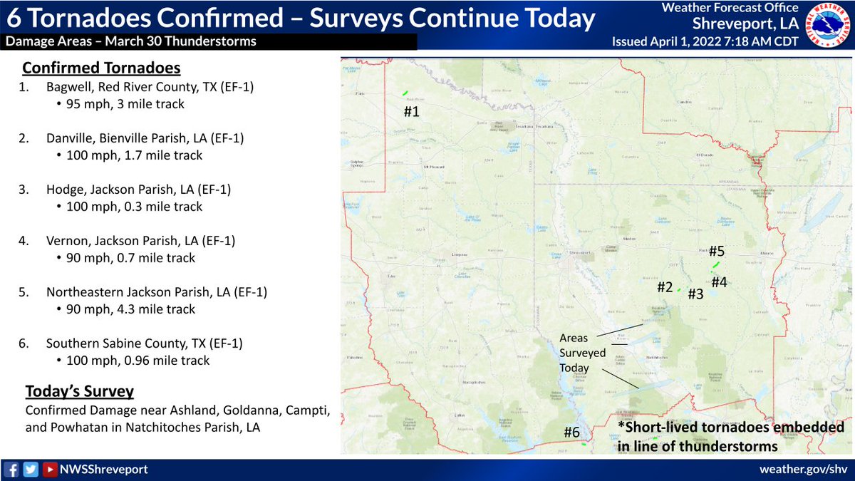
quote:
NWS Shreveport @NWSShreveport
[UPDATE] Six EF-1 tornadoes were confirmed so far from March 30th in our area. A survey team is out in the field again today surveying several damage locations in Natchitoches Parish, LA. #lawx #txwx
Posted on 4/1/22 at 12:48 pm to LegendInMyMind
So how do the tornado signatures seen on radar correlate to the actual intensities?
For example, the tornado that went through the University of Montevallo south of Birmingham had a very ominous radar signature including a strong indication of a debris field but it did relatively minor damage. It looked like the debris field was there when it went right through the University.
I know that's just one instance but I'd really like to know confidently quantitative assessments, at least to the level of a tornado being very dangerous or not, can be made from radar signatures by meteorologists in the moment.
This post was edited on 4/1/22 at 12:49 pm

Posted on 4/1/22 at 12:52 pm to rt3
This isn't appropriate. The National Weather Service doesn't need to try to be hip by joining the internet april fools fad.
quote:
NWS Shreveport @NWSShreveport
High temperatures for today, April 1st 2022, will range from 108° to 138° across the region. These temps will be achieved fairly early in the day, as a intense cold front rushes through this afternoon bringing an enormous amount of snow to the area. #AprilFools #NotARealForecast
Posted on 4/1/22 at 12:56 pm to Diseasefreeforall
quote:
So how do the tornado signatures seen on radar correlate to the actual intensities?
There's a good correlation out there that plots gate to gate wind speed (how fast the radar says its spinning) vs how high in the air the debris goes using CC on radar.
Posted on 4/1/22 at 1:56 pm to The Boat
quote:I find this more offensive
as a intense

 Page 91 of 92

Popular
Back to top