- My Forums
- Tiger Rant
- LSU Recruiting
- SEC Rant
- Saints Talk
- Pelicans Talk
- More Sports Board
- Fantasy Sports
- Golf Board
- Soccer Board
- O-T Lounge
- Tech Board
- Home/Garden Board
- Outdoor Board
- Health/Fitness Board
- Movie/TV Board
- Book Board
- Music Board
- Political Talk
- Money Talk
- Fark Board
- Gaming Board
- Travel Board
- Food/Drink Board
- Ticket Exchange
- TD Help Board
Customize My Forums- View All Forums
- Show Left Links
- Topic Sort Options
- Trending Topics
- Recent Topics
- Active Topics
Started By
Message
 2
2


Posted on 4/30/17 at 10:27 am to rt3
What's the OT weather experts' outlook for more storms in/around BR today? Are we done with the tornado warnings?
Posted on 4/30/17 at 10:34 am to rt3

Posted on 4/30/17 at 10:36 am to rt3
Just got the warning on my phone here in Covington
Posted on 4/30/17 at 10:37 am to rt3
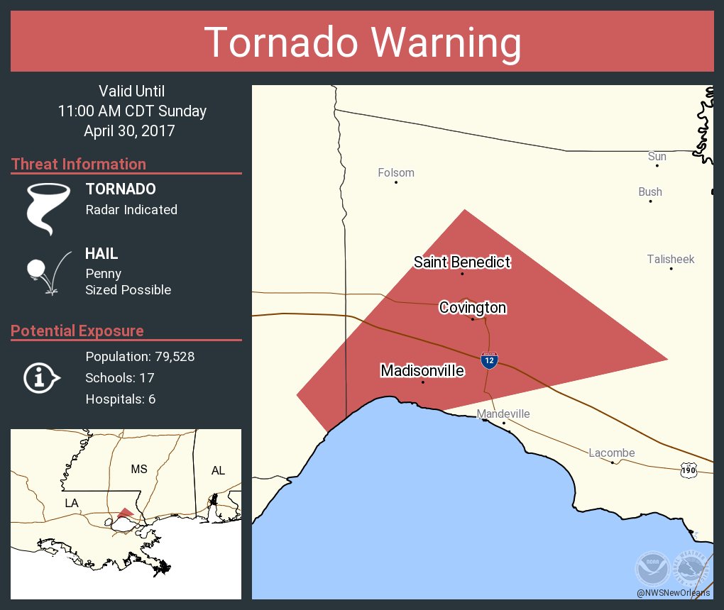
In words...
Tornado Warning
LAC103-105-301600-
/O.NEW.KLIX.TO.W.0066.170430T1531Z-170430T1600Z/
BULLETIN - EAS ACTIVATION REQUESTED
Tornado Warning
National Weather Service New Orleans LA
1031 AM CDT SUN APR 30 2017
The National Weather Service in New Orleans has issued a
* Tornado Warning for...
Northwestern St. Tammany Parish in southeastern Louisiana...
Southeastern Tangipahoa Parish in southeastern Louisiana...
* Until 1100 AM CDT
* At 1031 AM CDT, a severe thunderstorm capable of producing a
tornado was located near Madisonville, or 10 miles southwest of
Covington, moving northeast at 30 mph.
HAZARD...Tornado.
SOURCE...Radar indicated rotation.
IMPACT...Flying debris will be dangerous to those caught without
shelter. Mobile homes will be damaged or destroyed.
Damage to roofs, windows, and vehicles will occur. Tree
damage is likely.
* This dangerous storm will be near...
Madisonville around 1045 AM CDT.
Covington around 1055 AM CDT.
Abita Springs around 1100 AM CDT.
Tornado Warning
LAC103-105-301600-
/O.NEW.KLIX.TO.W.0066.170430T1531Z-170430T1600Z/
BULLETIN - EAS ACTIVATION REQUESTED
Tornado Warning
National Weather Service New Orleans LA
1031 AM CDT SUN APR 30 2017
The National Weather Service in New Orleans has issued a
* Tornado Warning for...
Northwestern St. Tammany Parish in southeastern Louisiana...
Southeastern Tangipahoa Parish in southeastern Louisiana...
* Until 1100 AM CDT
* At 1031 AM CDT, a severe thunderstorm capable of producing a
tornado was located near Madisonville, or 10 miles southwest of
Covington, moving northeast at 30 mph.
HAZARD...Tornado.
SOURCE...Radar indicated rotation.
IMPACT...Flying debris will be dangerous to those caught without
shelter. Mobile homes will be damaged or destroyed.
Damage to roofs, windows, and vehicles will occur. Tree
damage is likely.
* This dangerous storm will be near...
Madisonville around 1045 AM CDT.
Covington around 1055 AM CDT.
Abita Springs around 1100 AM CDT.
Posted on 4/30/17 at 10:37 am to rt3
I'm right in that cone off 1085 and 12. It is dark as shite right now.

Posted on 4/30/17 at 10:38 am to 4LSU2
shite's about to hit the fan here.
Posted on 4/30/17 at 10:39 am to 4LSU2
Same here. Could get real fun here shortly
Posted on 4/30/17 at 10:48 am to Usual Suspect
Severe Weather Statement
National Weather Service New Orleans LA
1045 AM CDT SUN APR 30 2017
LAC103-301555-
/O.CAN.KLIX.TO.W.0066.000000T0000Z-170430T1600Z/
St. Tammany LA-
1045 AM CDT SUN APR 30 2017
...THE TORNADO WARNING FOR NORTHWESTERN ST. TAMMANY PARISH IS
CANCELLED...
The storm which prompted the warning has weakened below severe
limits, and no longer appears capable of producing a tornado.
Therefore the warning has been cancelled. However gusty winds and
heavy rain are still possible with this thunderstorm.
Posted on 4/30/17 at 10:56 am to NorthEndZone
I see no signs of a tornado for this storm

Posted on 4/30/17 at 11:00 am to CypressTrout10
Lost power in Houma. Few lightning strikes really close to the house.
Posted on 4/30/17 at 11:07 am to FCP
quote:
What's the OT weather experts' outlook for more storms in/around BR today? Are we done with the tornado warnings?
Should be good for the rest of the day.
Posted on 4/30/17 at 11:14 am to slackster
It's coming down now. Sitting at the tarmac at Lakefront airport and it's coming down so hard the water is covering all the windows like a hose on full open.
Posted on 4/30/17 at 11:21 am to ihometiger
Reporting live from Kenna, LA
Wind is ferocious and the trees are whipping back and forth!!
Wind is ferocious and the trees are whipping back and forth!!
Posted on 4/30/17 at 11:24 am to VermilionTiger
Finally coming down with some force Uptown.
Posted on 4/30/17 at 11:44 am to QuietTiger
44 MPH wind gust reported at Lakefront Airport
Posted on 4/30/17 at 12:00 pm to rt3
apparently reports of someone being struck by lightning in Mississippi
Posted on 4/30/17 at 12:07 pm to Geaux23
What about jazz fest
Posted on 4/30/17 at 12:08 pm to kjntgr
Got a notification earlier they pushed back the start time today. I don't know if they plan on canceling or what.
I went the last two days and was sitting today out anyway
I went the last two days and was sitting today out anyway

Posted on 4/30/17 at 12:09 pm to SuperSaint
Causeway closed in both directions
Traffic brought to you by.....
Safe Auto Insurance
Traffic brought to you by.....
Safe Auto Insurance

 Page 16 of 17

Popular
Back to top