- My Forums
- Tiger Rant
- LSU Recruiting
- SEC Rant
- Saints Talk
- Pelicans Talk
- More Sports Board
- Fantasy Sports
- Golf Board
- Soccer Board
- O-T Lounge
- Tech Board
- Home/Garden Board
- Outdoor Board
- Health/Fitness Board
- Movie/TV Board
- Book Board
- Music Board
- Political Talk
- Money Talk
- Fark Board
- Gaming Board
- Travel Board
- Food/Drink Board
- Ticket Exchange
- TD Help Board
Customize My Forums- View All Forums
- Show Left Links
- Topic Sort Options
- Trending Topics
- Recent Topics
- Active Topics
Started By
Message
re: Tornado! Large PDS Watch Issued for Portions of LA & MS
Posted on 11/29/22 at 7:28 am to LegendInMyMind
Posted on 11/29/22 at 7:28 am to LegendInMyMind
It’s always central and southern ms. The forecast always starts up here and it moves south. Yazoo city to Hattiesburg
 0
0

Posted on 11/29/22 at 7:32 am to Roll Tide Ravens
3 am? Damn this shite gonna hang around awhile
Posted on 11/29/22 at 8:45 am to deltaland
well... I guess I'll in be in this thread a lot today as central Louisiana seems to be involved in this
here's what Nick Mik says this morning (as he's trying to fight off the flu)
here's what Nick Mik says this morning (as he's trying to fight off the flu)
quote:
Meteorologist Nick Mikulas
Our severe threat continues to increase if anything, and it looks like a very busy day is in store across the area. All modes of severe weather are likely as scattered supercells develop as soon as noon, and move quickly from southwest to northeast. Damaging wind, large to very large hail in excess of 2 inches in diameter, and isolated tornadoes, some potentially strong, are possible from noon to midnight.
The most concerning part of this potential severe outbreak is that the storm mode should mainly be scattered supercells as they will be forming well ahead of the cold front. The environment in place will allow the atmosphere to quickly reload with instability, so some areas could see multiple supercells. Basically, if you have a strong storm move through, that doesn’t necessarily mean you won’t see another.
No need to drag this out too long. You get the idea. I think my fever broke last night as I woke up in a puddle of sweat, and have no fever 8 hours after my last dose of NyQuil. That said, I’m hopefully going back to bed for a few hours so I’m ready to roll once this gets going. If you’re one of those that ignores tornado warnings, today would not be the day to do that. Of course, with all this gloom and doom, there are times where things just don’t pan out. Let’s hope for that, but be ready for the potential, as this has the potential to be a significant event for our area. I’m posting the SPC four panel that shows the risk for each severe mode. I would have higher tornado potential in our area, but SPC is definitely a smart group of meteorologists. Also, note the 30% hail risk overhead. If anything, garage the cars if possible. I’ll update soon after I wake up.

This post was edited on 11/29/22 at 8:46 am

Posted on 11/29/22 at 8:49 am to Strannix
From the Birmingham weather office...
Line this up with the Jackson forecast

Jackson...

Line this up with the Jackson forecast
Jackson...
Posted on 11/29/22 at 8:56 am to East Coast Band
quote:
NWS New Orleans @NWSNewOrleans
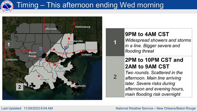
Severe weather and flood potential timing for today through tonight

Posted on 11/29/22 at 8:59 am to East Coast Band
quote:
I knew they wouldn't let Alabama off the hook.
For places like Birmingham, there will have to be a dramatic change in the atmosphere over the next 12-15 hours or so. Where I live just north of Birmingham, it was 32.7 degrees this morning. It doesn't feel at all like we're going to have severe weather in the next 24 hours. I know it doesn't take much instability in the winter season to produce severe weather, but there is still going to have to be some substantial advection to overcome the current airmass across central Alabama.
I guess how far the warmer and more unstable air makes it into Alabama will be the key for us. There may be a pretty sharp cutoff between where storms can get rooted at the surface and where they stay elevated. I think west of I-65 and south of I-20/59 is where the highest risk in AL will be, as that is where there may be enough overlap in dynamics and unstable air.

Posted on 11/29/22 at 8:59 am to rt3
Tornado forecast
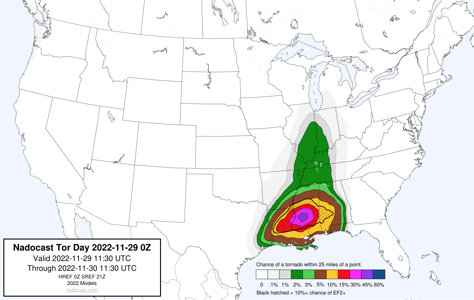
Significant tornado (EF2+)
Significant tornado (EF2+)
Posted on 11/29/22 at 9:00 am to Roll Tide Ravens
I'm certainly glad I now have a carport to put my truck in on days like today... currently
Posted on 11/29/22 at 9:47 am to rt3
One thing to watch will be if we can get a mess of storms to fire in extreme south LA and MS. If that can happen, it might be just enough to cut off some of the flow northward. Those storms would have a severe risk, but not quite what farther north is playing with, and they would likely be crowded. Just a wait and see on that, though.
Posted on 11/29/22 at 10:11 am to RebelExpress38
A 45% tornado area is rare for November
Hell it’s rare for April
Hell it’s rare for April
Posted on 11/29/22 at 10:12 am to LegendInMyMind
Pretty clear in south ms so far.
First severe warned storm just north of Grenada
First severe warned storm just north of Grenada
Posted on 11/29/22 at 10:23 am to Strannix
quote:
Where do you think this thing lines out? In NWLA we are on the edge of the marginal/enhanced but not showing great rain chances. On another note what is the main determinant on why/where a big front lines out or not? Moisture?
The thing is, we have weak forcing throughout the day today. Meaning, storm mode will favor cellular development. The only thing that should really increase that forcing and make the system "line out" would be the LLJ (Low Level Jet) which won't really get cranking good or be fully lined up so that it is an overwhelming influence until well after dark. CAMs have it forming a line in basically Eastern MS/Western AL with a broken line continuing on the Southern extent, which will still have a tornado threat.
This isn't a setup where you'll be waiting around for the front to see storms. Pre-frontal confluence bands will provide the forcing, maybe along with outflow boundaries from earlier storms that have moved out of the area.
Similar to earlier in the month in TX/AR we probably won't see cells pop up and blow their tops immediately. They will likely have to put in some work and go through some cell mergers to get and sustain a robust updraft.
Posted on 11/29/22 at 10:25 am to deltaland
quote:
First severe warned storm just north of Grenada
Will be interesting to see what this one does. The moisture hasn't made it that far North yet and instability hasn't really built, but it should have good shear.
Posted on 11/29/22 at 10:33 am to LegendInMyMind
SPC has expanded the moderate and enhanced risk areas:

I am sort of surprised. I am sort of questioning the extent the more unstable air can make it into north Alabama.
I am sort of surprised. I am sort of questioning the extent the more unstable air can make it into north Alabama.
Posted on 11/29/22 at 10:37 am to Roll Tide Ravens
quote:
I am sort of surprised. I am sort of questioning the extent the more unstable air can make it into north Alabama.
I thought the sky above my house went from yellow to orange.
In North AL shear will be the big thing. We will be closer to the LLJ, too. It still looking messy as it moves farther East.
Posted on 11/29/22 at 10:38 am to Roll Tide Ravens
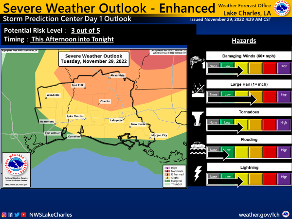
SPC considered introducing a small high risk area but said there was still too much uncertainty.
quote:
Consideration was made to introduce a small HIGH risk, but still too much uncertainty in the exact corridor of highest risk since moisture is not yet in place and there is no surface boundary to focus on.
Posted on 11/29/22 at 10:40 am to Roll Tide Ravens
It feels unstable as shite here. Wind is howling and it’s already 70 degrees. Forecast called for mid 60s and cloudy at this point but it’s 70 and the sun is out
Seems to be trending in a not good way
Seems to be trending in a not good way
Posted on 11/29/22 at 10:41 am to Roll Tide Ravens
I don't think they need a High. Roll with the MOD and issue MCDs to cover the developments.
Posted on 11/29/22 at 10:42 am to deltaland
quote:
It feels unstable as shite here. Wind is howling and it’s already 70 degrees. Forecast called for mid 60s and cloudy at this point but it’s 70 and the sun is out
I've been watching your general area for a couple days now. If the models verify you will be warmer at 10pm than you are right now. Not by much, but a couple degrees.
Posted on 11/29/22 at 10:51 am to LegendInMyMind
The high today was supposed to be 70. My truck dash says 71 now

 Page 5 of 21

Popular
Back to top