- My Forums
- Tiger Rant
- LSU Recruiting
- SEC Rant
- Saints Talk
- Pelicans Talk
- More Sports Board
- Fantasy Sports
- Golf Board
- Soccer Board
- O-T Lounge
- Tech Board
- Home/Garden Board
- Outdoor Board
- Health/Fitness Board
- Movie/TV Board
- Book Board
- Music Board
- Political Talk
- Money Talk
- Fark Board
- Gaming Board
- Travel Board
- Food/Drink Board
- Ticket Exchange
- TD Help Board
Customize My Forums- View All Forums
- Show Left Links
- Topic Sort Options
- Trending Topics
- Recent Topics
- Active Topics
Started By
Message
re: Tornado! Large PDS Watch Issued for Portions of LA & MS
Posted on 11/28/22 at 11:52 am to LegendInMyMind
Posted on 11/28/22 at 11:52 am to LegendInMyMind
That skew-t brings up nightmares of statistics in meteorology
 1
1

Posted on 11/28/22 at 11:56 am to Park duck
quote:
That skew-t brings up nightmares of statistics in meteorology
Ha....I used to hate them. I'm doing better with them these days.
Posted on 11/28/22 at 12:03 pm to LegendInMyMind
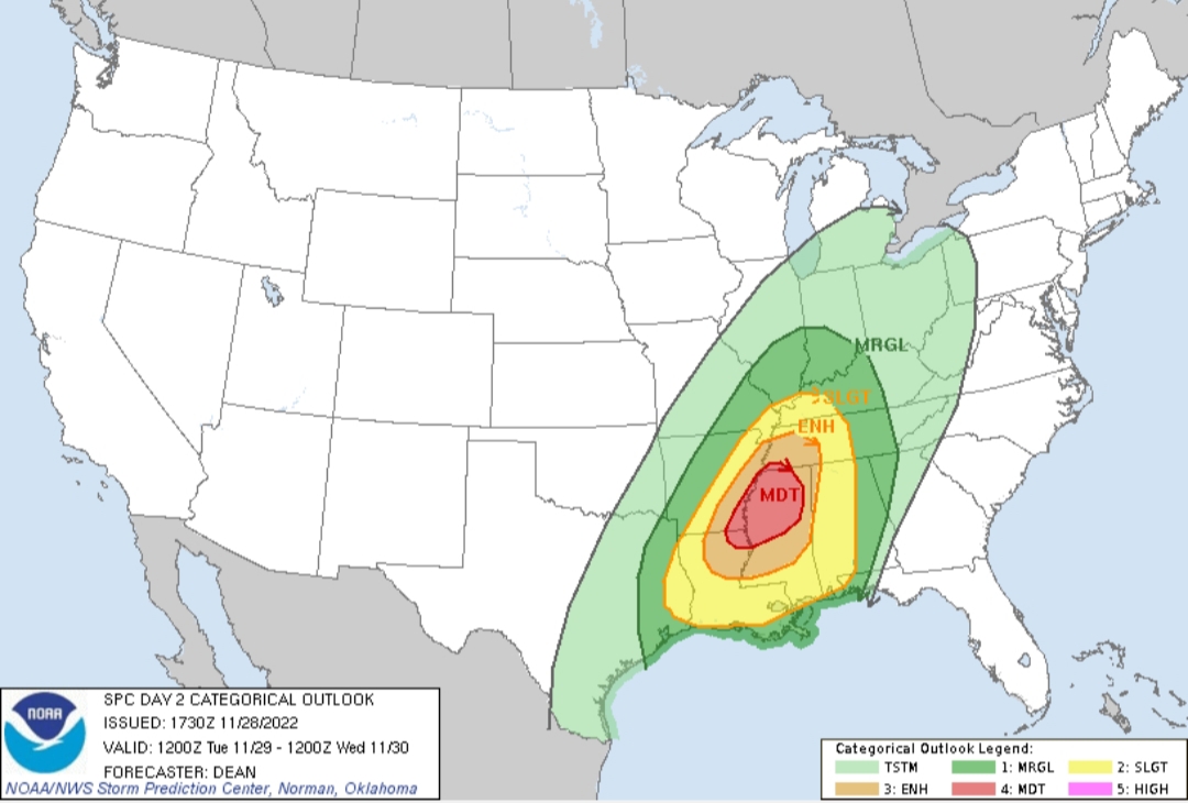
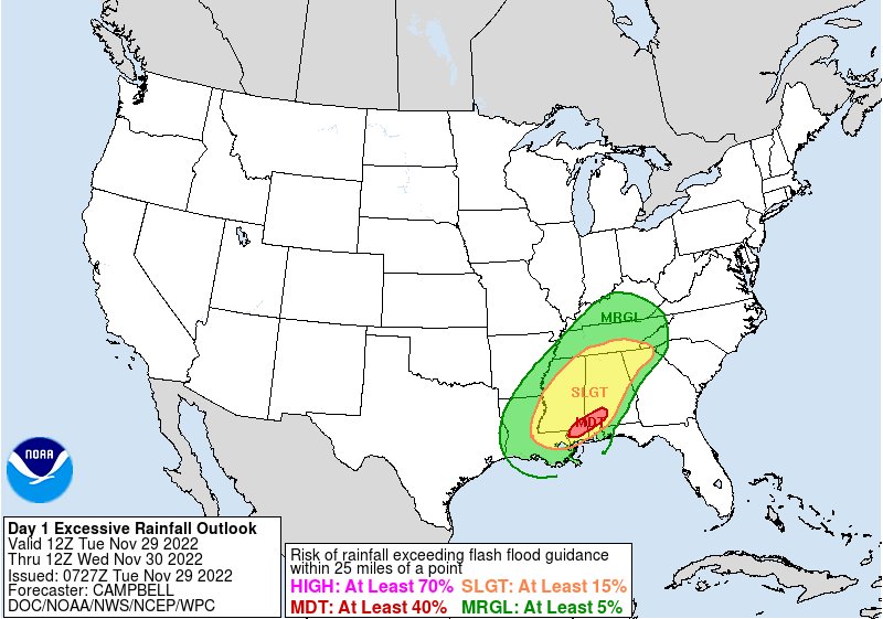
Wonder if we will get a high risk area? They’ve expanded the moderate risk area
Posted on 11/28/22 at 12:15 pm to deltaland
And they expanded things a bit with the latest update.
This post was edited on 11/28/22 at 12:20 pm
Posted on 11/28/22 at 4:14 pm to LegendInMyMind
My drive to stuttgart tomorrow evening may be interesting
Posted on 11/28/22 at 4:48 pm to LegendInMyMind
quote:
There will be a chance for some severe for us on Wednesday
is "us" the BR area or CENLA/NLA?
Posted on 11/28/22 at 5:03 pm to tigerinthebueche
quote:
is "us" the BR area or CENLA/NLA?
My response was to a central Alabama baw.
Posted on 11/28/22 at 5:10 pm to LegendInMyMind
@NWSShreveport
quote:
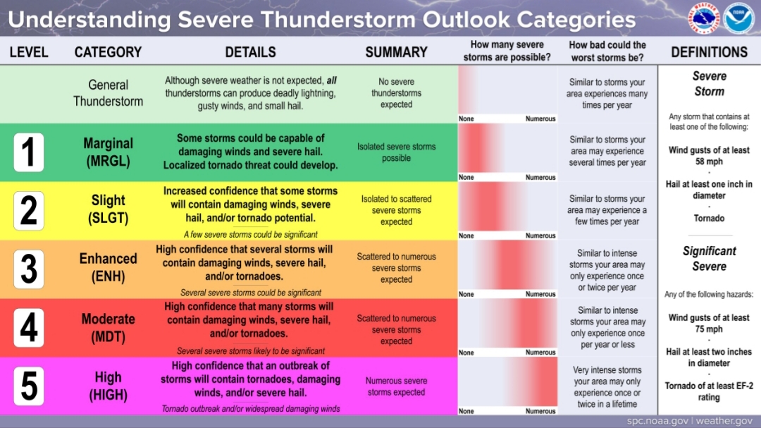
It is strongly encouraged to understand your threat category based on your location for storms forecasted Tuesday afternoon. A reminder, just because your threat level may be lower than another does not mean you should let your guard down. Be weather ready for any situation.
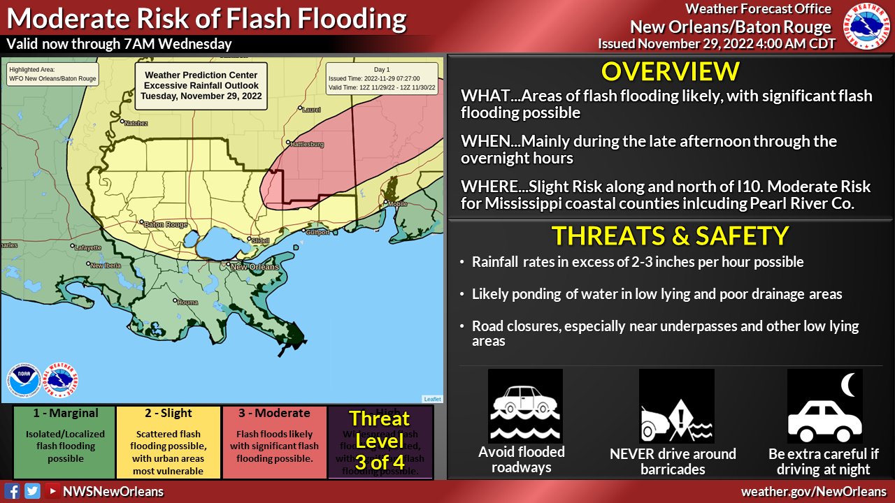
Posted on 11/28/22 at 8:16 pm to LegendInMyMind
quote:
For our Tennesippibama baw,
Awwwweeeeeeeee fuuuuccckkkkkk.....
quote:
, I've been meaning to tell you to check out the Tennessee Valley Weather channel on YouTube. They cover primarily your area and I know you're always looking for more covera
Oh. Well that's better news than I was expecting
Posted on 11/28/22 at 8:39 pm to Wishnitwas1998
Delete
This post was edited on 11/28/22 at 8:39 pm

Posted on 11/28/22 at 9:28 pm to LegendInMyMind
Posted on 11/28/22 at 9:43 pm to RebelExpress38
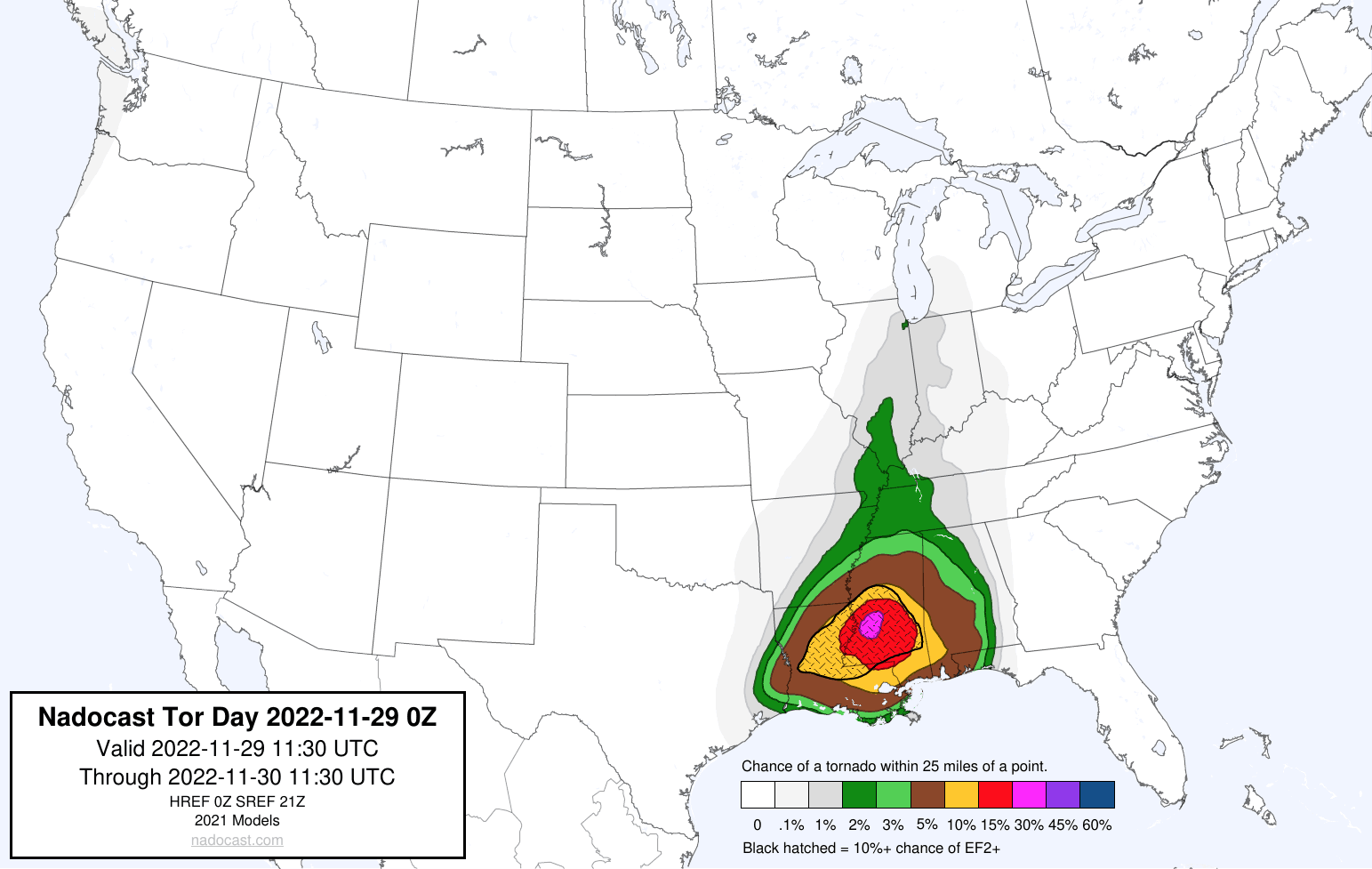
Nadocast has caused a kerfuffle today. It is significantly farther South than the SPC MOD. They differed last December, too, and SPC came out on top.
I fully see why Nadocast favors the more Southern mode. I'm kind of leaning that way, too.
I fully see why Nadocast favors the more Southern mode. I'm kind of leaning that way, too.
This post was edited on 11/28/22 at 9:45 pm
Posted on 11/28/22 at 11:07 pm to LegendInMyMind
The trend with the CAMs really does seem to be favoring central Louisiana into to MS. That is problematic because the parameters down there are stout. In all likelihood the instability will hit its ceiling in that area. There won't be a lack of moisture and shear will be plentiful.
Don't sleep on this tomorrow if you're in the Alex, Monroe, Vicksburg and areas NE of there, especially. Delta, you could very well see some legit action. Modeled soundings pretty much on top of you have been impressive.
Don't sleep on this tomorrow if you're in the Alex, Monroe, Vicksburg and areas NE of there, especially. Delta, you could very well see some legit action. Modeled soundings pretty much on top of you have been impressive.
This post was edited on 11/28/22 at 11:08 pm

Posted on 11/29/22 at 4:41 am to LegendInMyMind

Posted on 11/29/22 at 5:29 am to LegendInMyMind
SPC has shifted the moderate risk area a bit further south, and expanded the enhanced risk slightly further east.

Tornado Probabilities (probability of a tornado within 25 miles of a given point):

Tornado Probabilities (probability of a tornado within 25 miles of a given point):
This post was edited on 11/29/22 at 5:31 am
Posted on 11/29/22 at 5:47 am to rds dc
odds i die from a tornado or gunshot in jackson today?
Posted on 11/29/22 at 5:53 am to Bobby OG Johnson
Posted on 11/29/22 at 5:56 am to Roll Tide Ravens
From NWS Jackson:


Posted on 11/29/22 at 6:07 am to LegendInMyMind
I knew they wouldn't let Alabama off the hook.

Posted on 11/29/22 at 6:45 am to LegendInMyMind
quote:
LegendInMyMind
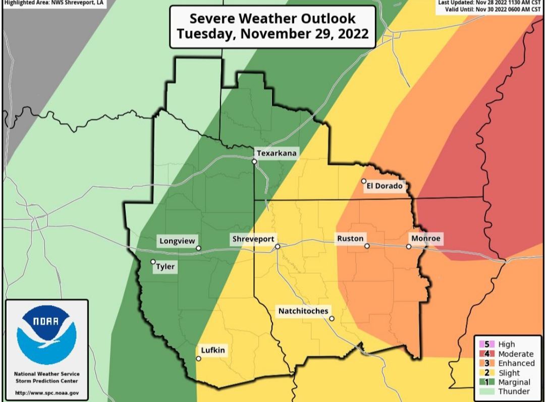
Where do you think this thing lines out? In NWLA we are on the edge of the marginal/enhanced but not showing great rain chances. On another note what is the main determinant on why/where a big front lines out or not? Moisture?

 Page 4 of 21

Popular
Back to top