- My Forums
- Tiger Rant
- LSU Recruiting
- SEC Rant
- Saints Talk
- Pelicans Talk
- More Sports Board
- Fantasy Sports
- Golf Board
- Soccer Board
- O-T Lounge
- Tech Board
- Home/Garden Board
- Outdoor Board
- Health/Fitness Board
- Movie/TV Board
- Book Board
- Music Board
- Political Talk
- Money Talk
- Fark Board
- Gaming Board
- Travel Board
- Food/Drink Board
- Ticket Exchange
- TD Help Board
Customize My Forums- View All Forums
- Show Left Links
- Topic Sort Options
- Trending Topics
- Recent Topics
- Active Topics
Started By
Message
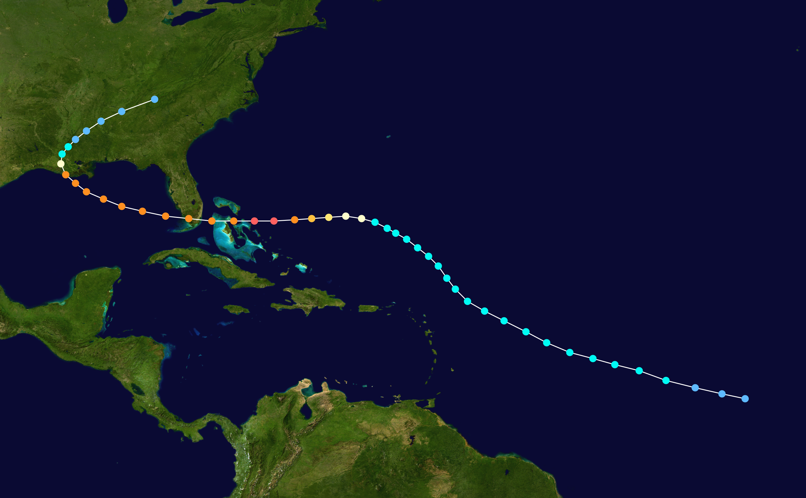
re: Storm Tracking Thread: Post Tropical Storm Hermine
Posted on 8/23/16 at 2:23 pm to TigerstuckinMS
Posted on 8/23/16 at 2:23 pm to TigerstuckinMS
quote:
Oh, you mean the most intense storm ever measured in the Gulf of Mexico that devastated a large portion of Louisiana? Hurricane Rita.
I like this post, cause most say Katrina.
 2
2


Posted on 8/23/16 at 2:24 pm to GEAUXmedic
Both storms sucked!
Posted on 8/23/16 at 2:24 pm to GEAUXmedic
More from Larry Cosgrove:
quote:
12z Operational ECMWF model with 500MB features. Note the huge heat ridge that steers the potential strong hurricane further west. I repeat my suspicion that the storm will be forced to take a more westward path until the subtropical high erodes. Two complications here. Wind and surge with a large and slow moving powerful circulation. And of course heavy rainfall, which if the system comes in on the west side of LA (say Sabine Pass), could prove to be a debacle. I will also say that the possibility exists for a stall upon landfall, IF the ridging is intact and northern shortwave energy does not crease the anticyclone.
Posted on 8/23/16 at 2:25 pm to GEAUXmedic
I can't give any credence to these types of predictions 8 days out. 3 days from now I think we will have a pretty clear picture. 5 days we will know pretty much for sure.
Posted on 8/23/16 at 2:26 pm to GEAUXmedic
frick everything that guy just said.

Posted on 8/23/16 at 2:26 pm to GEAUXmedic
Now that's not good.
Posted on 8/23/16 at 2:27 pm to GEAUXmedic
quote:
More from Larry Cosgrove
That is basically worse possible scenario. hope he is waaaay off on that
Posted on 8/23/16 at 2:28 pm to Dizz
quote:
frick everything that guy just said.
+10000000000
Posted on 8/23/16 at 2:30 pm to GEAUXmedic
If that thing stalls on this state then everyone just needs to move out because it's apparent someone doesn't want us living here. That would be an epic disaster.
Posted on 8/23/16 at 2:31 pm to GEAUXmedic
Whoa! Now this would be very bad if what he says were to come true.
Posted on 8/23/16 at 2:31 pm to deuce985
If that storm hits east of the Sabine River, anywhere near, say Atchafalaya, and then stalls over SE LA, we are fricked.
Hopefully this is all nothing.
Hopefully this is all nothing.
Posted on 8/23/16 at 2:35 pm to LSU2001
quote:
Parts of that model sure look a lot like a 2005 storm that shall not be named
Hopefully it doesn't resemble something like Andrew. Granted, Andrew was a beast going into Florida in the first place, but it went through Andrew and emerged in the GOM very near where the current Euro model is forecasting.
This post was edited on 8/23/16 at 2:36 pm
Posted on 8/23/16 at 2:38 pm to Fun Bunch
quote:
If that storm hits east of the Sabine River, anywhere near, say Atchafalaya, and then stalls over SE LA, we are fricked
That wishcasting is fear mongering at its finest. None of the models have it going that far west and none of them suggest a stall, but that guy says it is a "suspicion" he has.
The storm could end up doing that precisely, but there is no scientific reason to believe that at this time other than a hunch.
Posted on 8/23/16 at 2:39 pm to GEAUXmedic
quote:
12z Operational ECMWF model with 500MB features. Note the huge heat ridge that steers the potential strong hurricane further west. I repeat my suspicion that the storm will be forced to take a more westward path until the subtropical high erodes. Two complications here. Wind and surge with a large and slow moving powerful circulation. And of course heavy rainfall, which if the system comes in on the west side of LA (say Sabine Pass), could prove to be a debacle. I will also say that the possibility exists for a stall upon landfall, IF the ridging is intact and northern shortwave energy does not crease the anticyclone.

Posted on 8/23/16 at 2:41 pm to GeauxLSUGeaux
So is Larry generally right?
Posted on 8/23/16 at 2:42 pm to GeauxLSUGeaux
Are there any good Twitter follows for hurricane forecasting?
Posted on 8/23/16 at 2:44 pm to slackster
quote:
That wishcasting is fear mongering at its finest. None of the models have it going that far west and none of them suggest a stall, but that guy says it is a "suspicion" he has.
That's exactly what it is. Some of the internet "meterologists" cream their pants about these scenarios.
This may sound stupid but I want to see what Bob Breck has to say. He was the very first guy, even when Katrina was on the other side of Florida, to call the track it took and to start warning people.
Posted on 8/23/16 at 2:45 pm to LSU1018
quote:
So is Larry generally right?
Larry wouldn't put any actual faith into the shite he's saying. Sure, it is possible, but it isn't likely. He's going to discuss the worst case scenario 8 days out because people it gets people on weather forums all worked up.
I cannot stand irresponsible shite like that when it pops up in these threads. If you want to throw out suspicions and hunches as an average Joe, go right ahead, but when it comes from actual meteorologists or people posing as experts, it is irresponsible without the proper caveats.
Posted on 8/23/16 at 2:45 pm to kadillak
It's still to early to tell what the storm will do, but man, it would be the end of South LA as we know it to have another massive hurricane hit us right now when we're already devastated.
My family already lost our house, many of you did as well, or did during Katrina or Rita. I wouldn't wish that on anybody.
Let's hope the models are wrong.
My family already lost our house, many of you did as well, or did during Katrina or Rita. I wouldn't wish that on anybody.
Let's hope the models are wrong.

Posted on 8/23/16 at 2:46 pm to GEAUXmedic
quote:
@MJVentrice The fate of #99L is absolutely fascinating. We have another battle brewing between the Euro and GFS. Euro usually is king here
fwiw Mike's an awesome guy and really knows his shite.

 Page 5 of 175

Popular
Back to top