- My Forums
- Tiger Rant
- LSU Recruiting
- SEC Rant
- Saints Talk
- Pelicans Talk
- More Sports Board
- Fantasy Sports
- Golf Board
- Soccer Board
- O-T Lounge
- Tech Board
- Home/Garden Board
- Outdoor Board
- Health/Fitness Board
- Movie/TV Board
- Book Board
- Music Board
- Political Talk
- Money Talk
- Fark Board
- Gaming Board
- Travel Board
- Food/Drink Board
- Ticket Exchange
- TD Help Board
Customize My Forums- View All Forums
- Show Left Links
- Topic Sort Options
- Trending Topics
- Recent Topics
- Active Topics
Started By
Message
re: Sally - Moving towards Georgia - Potential for Significant Flooding
Posted on 9/13/20 at 11:09 pm to beachdude
Posted on 9/13/20 at 11:09 pm to beachdude
quote:
one plotted the approach of hurricanes on a grid map of latitude and longitude.
I had a tracking chart every year as a child. Of course, got my coordinates from John Hope on The Weather Channel vs the radio or however you spelled it.
 3
3

Posted on 9/13/20 at 11:11 pm to slackster
quote:
Didn't realize we passed 100 pages. It's been a grind I guess.
When I went to bed this morning at 6 we where around the upper 40s. That was a couple of hours after everyone in SELA got there Sunday morning wake up call. If that had not gone out we'd still be in the 70s.
Posted on 9/13/20 at 11:12 pm to Duke
quote:
I had a tracking chart every year as a child
In the late 80's we had a sweet arse program on our Tandy TL1000
This post was edited on 9/13/20 at 11:13 pm

Posted on 9/13/20 at 11:17 pm to biohzrd
Where do y’all find the storm surge predictions?

Posted on 9/13/20 at 11:17 pm to fightin tigers
quote:
Wait, is Twenty the name of the "T" storm or the number?
The name for the “T” storm this year is “Teddy.” That’s Tropical Depression 20 out there right now. It wouldn’t get a name until it hit Tropical Storm status.
Posted on 9/13/20 at 11:20 pm to Geaux23
quote:
Where do y’all find the storm surge predictions?
3 Storm Surge graphics on the NHC page for Sally
Posted on 9/13/20 at 11:21 pm to slackster
Thanks slack

Posted on 9/13/20 at 11:27 pm to Duke
quote:
I had a tracking chart every year as a child. Of course, got my coordinates from John Hope on The Weather Channel vs the radio or however you spelled it.
My Grandfather had a cool metal one on the wall by his chair with a round hurricane magnet and a bunch of little traingles to track the path. Wish I still had it for old times sake...
This post was edited on 9/13/20 at 11:28 pm
Posted on 9/13/20 at 11:27 pm to rds dc
1 day out and they still dont know where tf this thing is going
Posted on 9/13/20 at 11:28 pm to slackster
NHC is back at the LA / MS border

Posted on 9/13/20 at 11:29 pm to DVinBR
quote:
1 day out and they still dont know where tf this thing is going
Pretty narrow window.
Posted on 9/13/20 at 11:30 pm to Clockwatcher68
Why is there a tropical storm warning for Vermillion Bay?
Posted on 9/13/20 at 11:32 pm to Clockwatcher68
Was the track edited since the 10pm update?

Posted on 9/13/20 at 11:34 pm to fightin tigers
Reed Timmer just arrived in Bay St. Louis.
Posted on 9/13/20 at 11:37 pm to beachdude
quote:
Why is there a tropical storm warning for Vermillion Bay?
I guess if the storm takes the western-most path within the cone, those are the conditions you could expect in Vermilion Bay. One of the weather gurus on here can correct if my reasoning is BS.

Posted on 9/13/20 at 11:39 pm to Duke
Models seem to be shifting ever so slightly back west across the board so far it seems.
I’m making this post before theyre 100% done but that’s what the speculation is. Still landfalling in MS or LA/MS border
ETA: and the expected downvotes even though Duke said the same thing a page or so ago
I’m making this post before theyre 100% done but that’s what the speculation is. Still landfalling in MS or LA/MS border
ETA: and the expected downvotes even though Duke said the same thing a page or so ago
This post was edited on 9/13/20 at 11:44 pm
Posted on 9/13/20 at 11:42 pm to BottomFeeder
quote:
Was the track edited since the 10pm update?
That is the 10 pm update, and was on the NHC website when I posted. Beyond that, I don’t know. I think they do a pretty damn good job with their forecasts... especially within a day or two of landfall.

Posted on 9/13/20 at 11:46 pm to Clockwatcher68
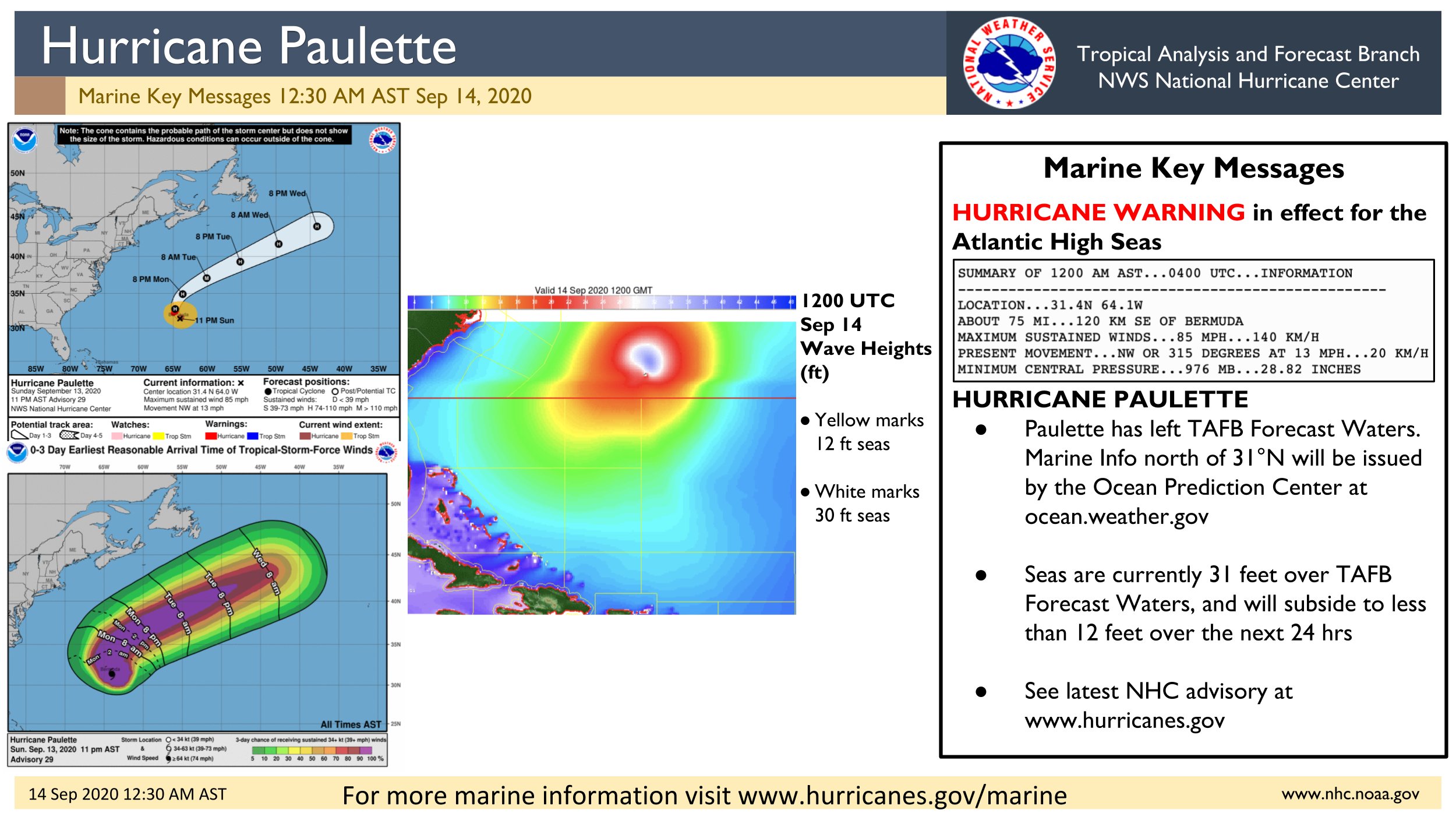
quote:
[12:45am AST Sep 14] Hurricane #Paulette is producing 31ft seas over TAFB Forecast Waters. Marine info north of 31°N will be issued by @NWSOPC
Posted on 9/13/20 at 11:48 pm to Bobby OG Johnson
Poor Bermuda. Looks like it will be a major hurricane when it goes past it.

Posted on 9/13/20 at 11:48 pm to Bobby OG Johnson
Holy crap

 Page 103 of 298

Popular
Back to top