- My Forums
- Tiger Rant
- LSU Recruiting
- SEC Rant
- Saints Talk
- Pelicans Talk
- More Sports Board
- Fantasy Sports
- Golf Board
- Soccer Board
- O-T Lounge
- Tech Board
- Home/Garden Board
- Outdoor Board
- Health/Fitness Board
- Movie/TV Board
- Book Board
- Music Board
- Political Talk
- Money Talk
- Fark Board
- Gaming Board
- Travel Board
- Food/Drink Board
- Ticket Exchange
- TD Help Board
Customize My Forums- View All Forums
- Show Left Links
- Topic Sort Options
- Trending Topics
- Recent Topics
- Active Topics
Started By
Message
re: Tornado! Threat Clearing Louisiana
Posted on 4/28/17 at 11:02 pm to beebefootballfan
Posted on 4/28/17 at 11:02 pm to beebefootballfan
quote:
Here is your reason for the bust. Same thing has happened all week.
The cap is just a symptom of the problem (probably not the best wording) that caused the bust. The actual reason was that the timing was off with the pieces of energy rotating around the base of the trough and that the trough was slower and deeper than what the models were showing earlier in the week. That allowed a prolonged period of SW flow off the high terrain of Mexico that transported warm dry air out in front of the system, that is the cap. Even so, with a much stronger cap in place than expected, the 00z FWD sounding showed that the cap had basically been eroded but there was not trigger for convective initiation since the next piece of energy hasn't kicked out across the warm sector. Timing is everything. Also, the slower deeper trough ejection will produce wind profiles tomorrow that are more supportive of a major squall line than discrete tornadic supercells.
 1
1

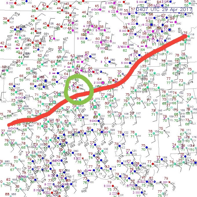
Posted on 4/28/17 at 11:15 pm to rds dc
Tonight is the perfect example of a highly conditional setup producing a tornado, kind of like the tornado that unexpectedly hit New Orleans a while back. Overall, things don't appear very supportive of tornadoes outside of the area right along the warm front (red line) and that is where the tornadic cell is. If it rides the warm front, then the threat will continue, if it moves off the front then the threat will diminish.

 Page 1 of 1


Popular
Back to top