- My Forums
- Tiger Rant
- LSU Recruiting
- SEC Rant
- Saints Talk
- Pelicans Talk
- More Sports Board
- Fantasy Sports
- Golf Board
- Soccer Board
- O-T Lounge
- Tech Board
- Home/Garden Board
- Outdoor Board
- Health/Fitness Board
- Movie/TV Board
- Book Board
- Music Board
- Political Talk
- Money Talk
- Fark Board
- Gaming Board
- Travel Board
- Food/Drink Board
- Ticket Exchange
- TD Help Board
Customize My Forums- View All Forums
- Show Left Links
- Topic Sort Options
- Trending Topics
- Recent Topics
- Active Topics
Started By
Message
2016 Baton Rouge Flood Map and Flood Insurance Map
Posted on 2/2/17 at 10:32 pm
Posted on 2/2/17 at 10:32 pm
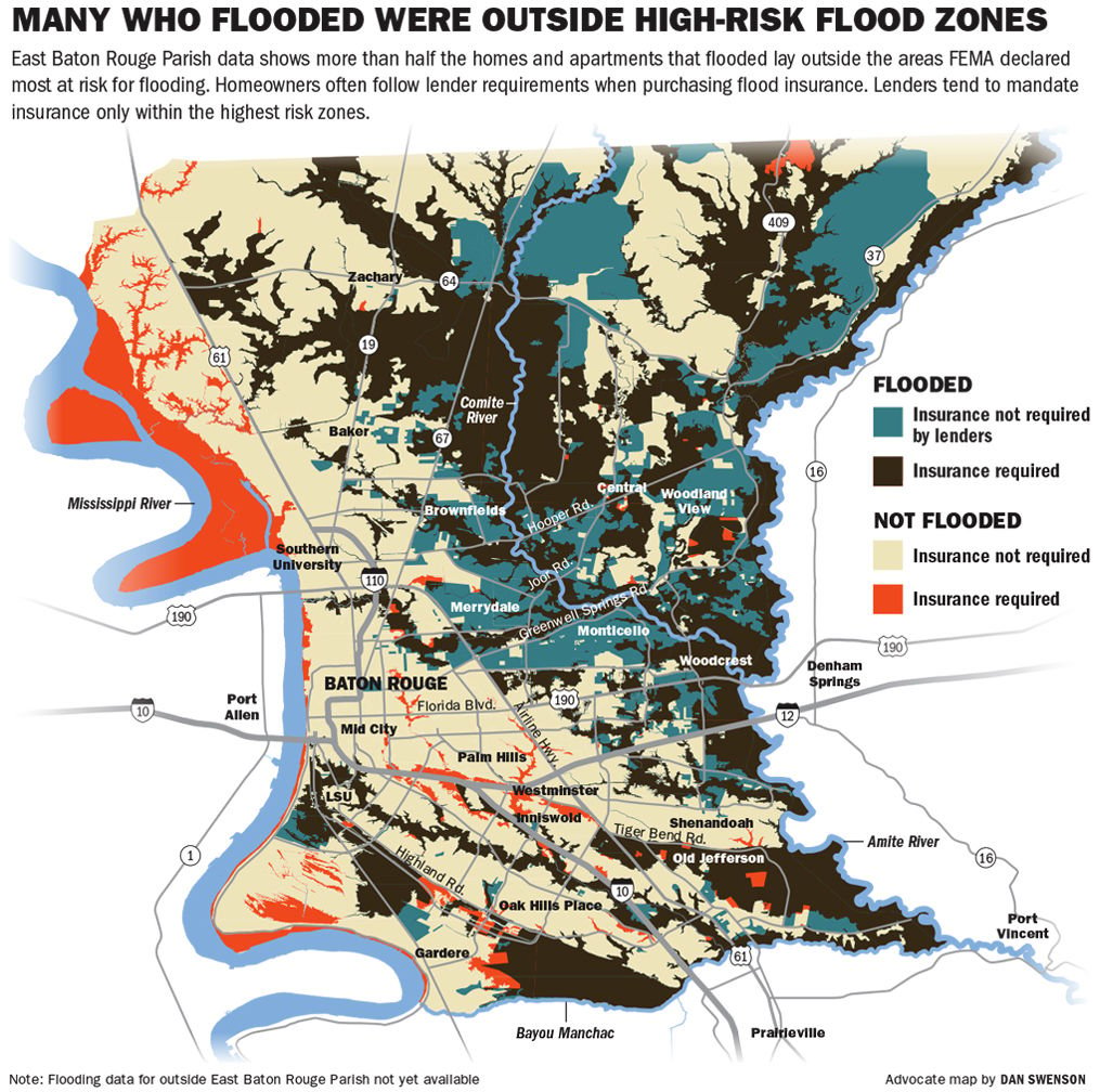
This is a pretty nice map of the flood and where insurance was required. What stands out are the few places where insurance was required but didn't flood while everything around it did. Some ol baws in Old Jefferson are lucky sumbitches.
This post was edited on 2/2/17 at 10:45 pm
 10
10


Posted on 2/2/17 at 10:37 pm to Jtigers99
Everyone is in a flood zone. The difference is simply the degree of risk.
Posted on 2/2/17 at 10:39 pm to Jtigers99
That swamp above Bayou Manchac saved a lot of homes along Burbank..
This post was edited on 2/2/17 at 10:42 pm
Posted on 2/2/17 at 10:41 pm to Jtigers99
Pretty fricking badass how the highland road bluff acts as a natural levee
Posted on 2/2/17 at 11:02 pm to Jtigers99
Many of those residences in green areas will now be required to carry flood insurance if they accept FEMA assistance.
Posted on 2/3/17 at 12:02 am to Jtigers99
Cool post, wish I could also see Livingston parish.

Posted on 2/3/17 at 5:13 am to Jtigers99
Can I get Livingston Parish map, or do we count?
Posted on 2/3/17 at 6:16 am to Jtigers99
The large red blob right below the word Jefferson is carriagewood estates. I live there. We were very lucky. We are required to have flood insurance. Someone in the neighborhood had a drone and the videos he posted were unreal. We were literally an island. We came about two to three feet of having water in the houses.

Posted on 2/3/17 at 7:01 am to Jtigers99
Central and surrounding areas got hammered so bad. I never realized how at-risk for river flooding that area is.
Posted on 2/3/17 at 7:14 am to Jtigers99
Pisses me off. I pay $1400 a year for flood insurance and didn't come close to flooding.
Posted on 2/3/17 at 7:41 am to Jtigers99
Yup I am lucky by inches.
The front part of Old Jefferson is higher and those people were ok.
Funny thing is when I drove in Sunday the area that always floods if you even cry by it on a dry day by the Cracker Barrel on Baringer Road was high and dry.
My place is paid for and did not flood but if I financed my place would require flood insurance. I do carry it and it is $1,300 a year with contents and structure.
I have been looking at some flooded homes to redo and rent but some people are asking more than they are worth after being flooded.
Now in River Oaks On Fontainebleau Dr I own two rental houses that flooded. This area never flooded until 2016. Luckily I did carry flood insurance and factor it into what I charge for rent.
i was surprised that Red Oaks had some water and Villa Del Ray. My parents own some homes they rent up in there.
Sherwood Forest I was lucky no damage to my rental homes. Two squeeked by no flood
damage.
My friend had 4 homes off Stevedale road off Florida Blvd in I believe Villa Cote. He said that the road would flood but never the homes. All four of his rental homes went under and he sold out.
This post was edited on 2/3/17 at 7:57 am

 Page 1 of 1


Popular
Back to top