- My Forums
- Tiger Rant
- LSU Recruiting
- SEC Rant
- Saints Talk
- Pelicans Talk
- More Sports Board
- Fantasy Sports
- Golf Board
- Soccer Board
- O-T Lounge
- Tech Board
- Home/Garden Board
- Outdoor Board
- Health/Fitness Board
- Movie/TV Board
- Book Board
- Music Board
- Political Talk
- Money Talk
- Fark Board
- Gaming Board
- Travel Board
- Food/Drink Board
- Ticket Exchange
- TD Help Board
Customize My Forums- View All Forums
- Show Left Links
- Topic Sort Options
- Trending Topics
- Recent Topics
- Active Topics
Started By
Message
 2
2

Posted on 9/9/15 at 4:46 pm to Fifthstring
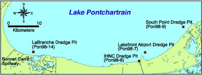
In 1998, a partnership was formed between the UNOCRL and the USGS to collect hydrographic data along the south shore of Lake Pontchartrain in order to document bathymetric change since the early 1900's. These hydrographic data were processed and computer-generated to produce bathymetric maps. Locations of dredge-pits and specific study areas are shown in Figure 38.
One of four significant holes in the Lake bottom on the south shore mapped by this survey is near South Point. The bathymetric data show that this hole is approximately 17 m (55.8 ft) deep.
The hole was created when sand was pumped from the Lake bottom to fill the Little Woods Canal, which ran parallel to the shoreline. Information from Orleans Levee District suggests that the sand was used to fill the canal prior to building the hurricane protection levee. Records show that clay from a borrow area near Howze Beach on the north shore was transported to the same site to cap the sand layer. This work took place in the 1970's.
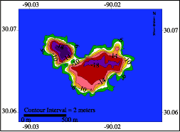
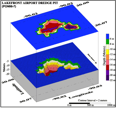
In 1998, a partnership was formed between the UNOCRL and the USGS to collect hydrographic data along the south shore of Lake Pontchartrain in order to document bathymetric change since the early 1900's. These hydrographic data were processed and computer generated to produce bathymetric maps. Location of dredge- pits and specific study areas are shown in Figure 34.
These bathymetric maps reflect two adjacent dredge holes located to the northeast of the Lakefront Airport runway (Figures 35, 36 and 37). The holes range in depth from 20 to 22 m (65.6-72.2 ft). Orleans Levee District documents show that this pit was excavated between 1977 and 1980, the material being used for an airport expansion project (Orleans Levee District communication).
This post was edited on 9/9/15 at 4:49 pm
Posted on 9/9/15 at 6:10 pm to Fifthstring
I've tried 4x never seen one. Did get into two huge schools of Jack's though.

 Page 1 of 1


Popular
Back to top