- My Forums
- Tiger Rant
- LSU Recruiting
- SEC Rant
- Saints Talk
- Pelicans Talk
- More Sports Board
- Fantasy Sports
- Golf Board
- Soccer Board
- O-T Lounge
- Tech Board
- Home/Garden Board
- Outdoor Board
- Health/Fitness Board
- Movie/TV Board
- Book Board
- Music Board
- Political Talk
- Money Talk
- Fark Board
- Gaming Board
- Travel Board
- Food/Drink Board
- Ticket Exchange
- TD Help Board
Customize My Forums- View All Forums
- Show Left Links
- Topic Sort Options
- Trending Topics
- Recent Topics
- Active Topics
Started By
Message
re: Ian Observation Thread (Storm Track and Radar inside)
Posted on 9/26/22 at 12:20 pm to Duke

Posted on 9/26/22 at 12:20 pm to Duke
quote:That’s what I’m thinking.
If you're in a good structure and know you're safe from flooding, it would probably be best to stay. Dont need people who are safe clogging the roads.
I just need to figure out if my truck is in danger of flooding and what to do with it if it is.
 2
2

Posted on 9/26/22 at 12:21 pm to Pepperoni
How often are the storm surge maps correct? I feel like for storms in Louisiana they are often grossly overstated. Can Tampa really expect 10 feet?
Posted on 9/26/22 at 12:23 pm to CaptainJ47
I’m always in the worst case scenario flood level area and haven’t flooded since I’ve been here for ~9 years.
Posted on 9/26/22 at 12:24 pm to CaptainJ47
quote:
How often are the storm surge maps correct? I feel like for storms in Louisiana they are often grossly overstated. Can Tampa really expect 10 feet?
The thing is, you don't really know. So, they will always err on the side of caution a bit. Remember that the NHC was shite on for overstating Laura's surge. Turns out that it verified to the tune of around 17'.

Posted on 9/26/22 at 12:25 pm to rds dc
Excellent NWS page that provides threat maps for wind, surge, flooding rain.
LINK to NWS Southern Region Tropical Webpage
From the local Tampa Weather Service:
LINK to NWS Southern Region Tropical Webpage
From the local Tampa Weather Service:
quote:
* SURGE: Prepare for life-threatening surge having possible devastating impacts across the Tampa Bay area.
quote:
* WIND: Prepare for life-threatening wind having possible devastating impacts across west central and southwest Florida.
quote:
FLOODING RAIN: Prepare for life-threatening rainfall flooding having possible extensive impacts across west central and southwest Florida.
quote:
TORNADOES: Prepare for a tornado event having possible limited impacts across west central and southwest Florida.
Posted on 9/26/22 at 12:28 pm to LanierSpots
quote:
Lots to do today...
Definitely. I shouldn’t even be on here right now...
Posted on 9/26/22 at 12:29 pm to titmouse
quote:
Hastings area
I’m north of you, I’m in county rd 210.
Posted on 9/26/22 at 12:29 pm to shallowminded
quote:
I’m north of you, I’m in county rd 210.
BINGO....

Posted on 9/26/22 at 12:31 pm to LegendInMyMind
I'm really concerned about the potential for Ian to be incredibly slow moving. Even if it is a Cat 1 or 2, that could really prolong the surge issues. Not to mention the flooding rains.
Posted on 9/26/22 at 12:34 pm to ReauxlTide222
DISCLAIMER: This is just one POSSIBLE outcome, but it is output from the best American weather model.
DISCLAIMER #2: I saw an image that looked like this for IDA and said to myself - that won't happen. Two days later it was happening.
Unless you are fully prepared to 'rough it out' for at least a few days and you are in a voluntary evacuation zone, just leave. The aftermath and recovery is worse than the storm itself for most.
If you are in a mandatory evac zone, just leave. It is miserable for several days. Property can be fixed when the time comes.
Posted on 9/26/22 at 12:35 pm to alphaandomega
quote:
FYI the charity is Here to Serve, we serve between 1000-1200 FREE hot meals twice a day. Last year we went to Lake Charles and Prarieville
What storms hit there?
Posted on 9/26/22 at 12:36 pm to CaptainJ47
quote:
How often are the storm surge maps correct? I feel like for storms in Louisiana they are often grossly overstated. Can Tampa really expect 10 feet?
I can assure you category 1, never made landfall in north Florida, Matthew went over 9 feet in storm surge where my dad had a beach house in northern Flagler county.
This post was edited on 9/26/22 at 12:37 pm
Posted on 9/26/22 at 12:37 pm to ReauxlTide222
My cousin and their kids are in Tarpon Springs. They’re locking up the house and bringing the outdoor furniture in the garage, and headed up to GA. Y’all be safe.
This post was edited on 9/26/22 at 12:41 pm
Posted on 9/26/22 at 12:39 pm to shallowminded
quote:
I’m north of you, I’m in county rd 210.
I hope beachwalk fills up with so much trash/debris

Posted on 9/26/22 at 12:40 pm to MoarKilometers
12z HMON would be an absolute disaster for tampa
Posted on 9/26/22 at 12:40 pm to MoarKilometers
quote:
I hope beachwalk fills up with so much trash/debris
Haha, I’m on the other side of 95..

Posted on 9/26/22 at 12:41 pm to maisweh
quote:
quote:
FYI the charity is Here to Serve, we serve between 1000-1200 FREE hot meals twice a day. Last year we went to Lake Charles and Prarieville
quote:
What storms hit there?
Sorry, Lake Charles (a little south of there at Cowboy Church) was 2021 (Delta)
And last years that we went to Prairieville (Fellowship Church) was Ida.
Posted on 9/26/22 at 12:41 pm to ReauxlTide222
Honest question, have you experienced a cat 3 storm in the last 9 years? Storm surge is nothing to play chicken with!
Posted on 9/26/22 at 12:44 pm to Cosmo
quote:
12z HMON would be an absolute disaster for Tampa.
Saw that. 951 mb and 120 knots right into St. Pete beach. Probably won't happen exactly like that, but even if it is close to that location and strength, it would be a disaster.
Posted on 9/26/22 at 12:47 pm to LegendInMyMind
QPF (rainfall) through next Saturday.
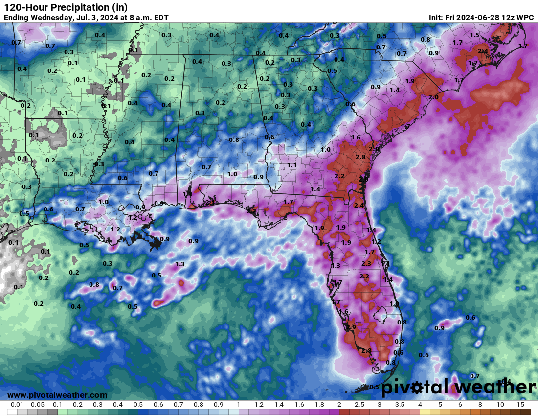
I do think this map has too much rain in Alabama.
I do think this map has too much rain in Alabama.
This post was edited on 9/26/22 at 12:48 pm

 Page 171 of 465

Popular
Back to top