- My Forums
- Tiger Rant
- LSU Recruiting
- SEC Rant
- Saints Talk
- Pelicans Talk
- More Sports Board
- Fantasy Sports
- Golf Board
- Soccer Board
- O-T Lounge
- Tech Board
- Home/Garden Board
- Outdoor Board
- Health/Fitness Board
- Movie/TV Board
- Book Board
- Music Board
- Political Talk
- Money Talk
- Fark Board
- Gaming Board
- Travel Board
- Food/Drink Board
- Ticket Exchange
- TD Help Board
Customize My Forums- View All Forums
- Show Left Links
- Topic Sort Options
- Trending Topics
- Recent Topics
- Active Topics
Started By
Message
Property Value Manchac South Pass
Posted on 12/15/21 at 8:37 am
Posted on 12/15/21 at 8:37 am
I'm no longer in La and due to a couple untimely deaths came into the deed to my grandpaw's old camp. I spent MANY weekends there as a child/teenager moving buckets of shell and broken concrete for a sea wall. (Labor payment in order to enjoy the weekend running trot lines at night and casting lines during the day.)
My grandpaw was one of the old timers down there who would sell his catch at the docks and to Middendorfs back in the day. The stories that old man could tell!
I know there's bound to be some people on this board familiar with that area. Just curious as to what the lot might be worth if I decide to sell it. I haven't been down there since Katrina and don't see me moving back to La anytime soon to rebuild.
 3
3


Posted on 12/15/21 at 9:27 am to Tiger_n_Texas
Water access only?

Posted on 12/15/21 at 9:37 am to Tiger_n_Texas
Where is at on south pass? Did the storm take out the camp? My family has a camp on North pass. That area got hit HARD from Ida.
Posted on 12/15/21 at 9:39 am to wickowick
quote:
Water access only?
Yes, water access only.
This post was edited on 12/15/21 at 9:40 am
Posted on 12/15/21 at 9:42 am to jdavid1
quote:
Where is at on south pass? Did the storm take out the camp? My family has a camp on North pass. That area got hit HARD from Ida.
I haven't been there in years, but I imagine it's gone or just piling left.
If you're familiar with the area, it was one of the first camps on the left heading towards Ponchatrain from Maurepas. Used to have an outhouse with a crescent moon attached to the pier for people to use as an emergency when they were out an about.
Posted on 12/15/21 at 9:53 am to Tiger_n_Texas
Your grandpa probably knew mine. He was a big time trot line guy in Manchac as well and had a camp up Manchac Canal. Lived there when I was a kid.
Posted on 12/15/21 at 10:07 am to jgthunt
quote:
Your grandpa probably knew mine. He was a big time trot line guy in Manchac as well and had a camp up Manchac Canal. Lived there when I was a kid.
I wish I could recall all the names and people from back then. One of his really good friends drowned in Maurepas early 2000s. He didn't take it well at all. I can count on one hand the number of trips he made down there after that. It was a case of an old seasoned fisherman not wearing his life jacket. Running a trot line and a storm rolled in quick. Line got caught in the prop, boat flipped, etc. If I recall, it took ~100 days to locate him because of the water temps. My grandpaw had warned him just a couple days earlier about not wearing it and relying on the ability to grab it in an instance.
Posted on 12/15/21 at 10:32 am to Tiger_n_Texas
is south pass the main pass, ie: pass manchac?
Posted on 12/15/21 at 10:38 am to cgrand
quote:
is south pass the main pass, ie: pass manchac?
Yes, South Pass is the main pass between Ponchtrain and Maurepas. North Pass runs from the South Pass (near Ponchtrain) and loops back towards I-55 by the boat launch. You have to have a shallow boat and low tide to make it under the train tracks there.
Posted on 12/15/21 at 10:50 am to Tiger_n_Texas
can you kinda show on a map where the lot is, and generally the lot size?
Posted on 12/15/21 at 10:54 am to Tiger_n_Texas
Unfortunately, a lot of those on the north side of the pass got wiped out. I have some pics on my phone a few days after the storm I can try and post.
To answer your original question, property value on the north pass isn't worth very much. Most people don't like that it's a wake zone and it's hard to keep boats from getting torn up. There is also something about where you can build due to the powerlines. You almost have to build out over the water to make it work, but since there was a camp there you may have something. It's just hard to say. A property with bulkhead, pylons for the camp, and some dock would be worth a lot more than bare property.
To answer your original question, property value on the north pass isn't worth very much. Most people don't like that it's a wake zone and it's hard to keep boats from getting torn up. There is also something about where you can build due to the powerlines. You almost have to build out over the water to make it work, but since there was a camp there you may have something. It's just hard to say. A property with bulkhead, pylons for the camp, and some dock would be worth a lot more than bare property.
Posted on 12/15/21 at 11:17 am to cgrand
quote:
can you kinda show on a map where the lot is, and generally the lot size?
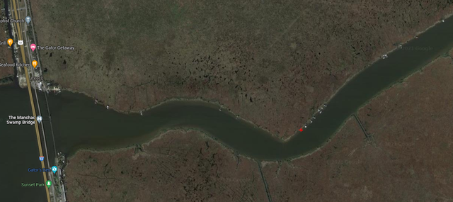
Red X in the pic. Not sure on lot size as I dont have a formal survey and the assessor's description isn't very good. I see mention of 171 Ft but that's it.
This post was edited on 12/15/21 at 11:19 am
Posted on 12/15/21 at 11:29 am to Tiger_n_Texas
That's the bigger camp up on tall pylons to the left of the sunken barge? If that's it the camp made it through the storm. It actually looked pretty good from what I could see. A lot better than most of the others.
Posted on 12/15/21 at 11:50 am to jdavid1
Ours was to the left of the barge. Tall camp is to the right. That camp was sold several years ago. Used to be owned by a crabber. (Cool guy, used to give us all the fresh and frozen softshells we wanted. Can't remember what storm it was, but I remember he and another crazy local boarded themselves up in the attic of the fire station because they refused to leave.) There was also a horseshoe shaped dock between the 2 camps where a huge shrimp boat would occasionally dock. Looking at satellite, looks like our camp is gone (not surprised) and the shrimp boat dock is mostly gone.
Posted on 12/15/21 at 6:37 pm to jgthunt
My grandparents lived on Galva Canal and my paw paw also ran lines in the pass. I'm sure they all knew each other. I spent many a summers and weekends down there.
Posted on 12/15/21 at 6:44 pm to GS3

Which one of these is it? I’ll try to find the physical description
This post was edited on 12/15/21 at 6:45 pm
Posted on 12/15/21 at 7:01 pm to jdavid1
Guy that went by “oil can” use to own the tall camp.
Nothing has been to the left of his for years.
Nothing has been to the left of his for years.

Posted on 12/15/21 at 10:19 pm to Manchac Man
quote:
Guy that went by “oil can” use to own the tall camp.
Nothing has been to the left of his for years.
Probably not since Isaac at least.
Posted on 12/15/21 at 10:30 pm to killinme_smalls
quote:
Which one of these is it? I’ll try to find the physical description
Thanks, its 9 mile.
Posted on 12/15/21 at 10:33 pm to Manchac Man
quote:
Guy that went by “oil can” use to own the tall camp
Never knew him as "oil can". Wonder if he was the one who bought it after the guy I knew. The guy I knew built the camp.

 Page 1 of 2

Popular
Back to top