- My Forums
- Tiger Rant
- LSU Recruiting
- SEC Rant
- Saints Talk
- Pelicans Talk
- More Sports Board
- Fantasy Sports
- Golf Board
- Soccer Board
- O-T Lounge
- Tech Board
- Home/Garden Board
- Outdoor Board
- Health/Fitness Board
- Movie/TV Board
- Book Board
- Music Board
- Political Talk
- Money Talk
- Fark Board
- Gaming Board
- Travel Board
- Food/Drink Board
- Ticket Exchange
- TD Help Board
Customize My Forums- View All Forums
- Show Left Links
- Topic Sort Options
- Trending Topics
- Recent Topics
- Active Topics
Started By
Message
re: Storm Tracking Thread: Post Tropical Storm Hermine
Posted on 8/27/16 at 8:26 pm to Costanza
Posted on 8/27/16 at 8:26 pm to Costanza
quote:
The google earth wind map that was posted a few pages back shows a lot more circulation at all levels with the latest update.
It's so bad arse when you turn the earth on its side, and are looking at Antarctica, in that link. Don't know shite about what it means, but the colors and fluidity are beautiful.
 0
0

Posted on 8/27/16 at 8:28 pm to Bob Sacamano
To me, it looks like it will head through Miami, then loop back around through north-central Fl. May keep going straight back into the Atlantic or could dump some water on the Smokey Mountains.
I'm less concerned with every day that passes.
I'm less concerned with every day that passes.
This post was edited on 8/27/16 at 8:50 pm

Posted on 8/27/16 at 8:32 pm to Chuker
quote:
for all intensive purposes
Posted on 8/27/16 at 8:33 pm to Chuker
Holy shite please tell me you did that on purpose.

Posted on 8/27/16 at 8:33 pm to heatom2
He sounds like Diane Deaton ftom WAFB.....
Posted on 8/27/16 at 8:36 pm to dukke v

last vis loop

Posted on 8/27/16 at 8:36 pm to Chuker
quote:
for all intensive purposes

Posted on 8/27/16 at 8:40 pm to Cosmo


Posted on 8/27/16 at 8:40 pm to Chuker
quote:
for all intensive purposes

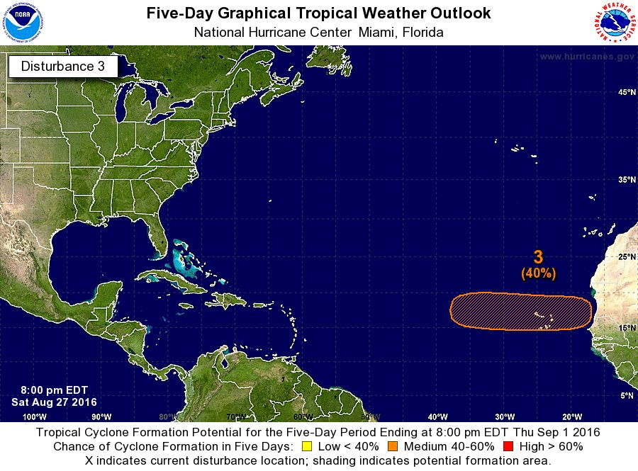
Posted on 8/27/16 at 9:02 pm to RazorBroncs
quote:
seems to be forming quite a bit from this image.
Theres about 30 posts in this thread that say the same thing since Wednesday, all u fellers gonna get weather blue balls

Posted on 8/27/16 at 9:02 pm to Chuker
Intensive purposes - is that like your "special purpose"?
Posted on 8/27/16 at 9:03 pm to Chuker
Nice edit, Mr. Mensa.
Posted on 8/27/16 at 9:14 pm to LSU1NSEC
Posted on 8/27/16 at 9:42 pm to Jim Rockford
IMO we should be looking at P25L more than 99L, it has unanimous support from the Global models. Yeah, I know models sucked for 99L, but 99L never had unanimous support.
Euro gives very strong support
Euro gives very strong support
quote:
@webberweather ~47/51 EPS members eventually develop the strong AEW that'll emerge from Africa in ~3 days, 39/51 develop it into a hurricane #Confident
This post was edited on 8/27/16 at 9:46 pm
Posted on 8/27/16 at 9:46 pm to GEAUXmedic
I have a feeling that the next post will be the dumbest one yet.
This post was edited on 8/27/16 at 9:50 pm

Posted on 8/27/16 at 9:48 pm to Ignignot
If this low doesn't turn into a Cat 5 hurricane and slam into Louisiana I will be pissed. I need something to break up this monotony that I call life
Posted on 8/27/16 at 9:49 pm to GEAUXmedic
Developing so far out, it should recurve, right?

Posted on 8/27/16 at 9:49 pm to GEAUXmedic
Looks more like we'll be getting a P3 N15
Posted on 8/27/16 at 9:56 pm to Jim Rockford
quote:
Developing so far out, it should recurve, right?
Lol, there's no way to tell. I was joking about 99L being so shitty. All this tells us is there's a high chance of a wave coming off Africa and actually lasting across the Atlantic.

 Page 118 of 175

Popular
Back to top