- My Forums
- Tiger Rant
- LSU Recruiting
- SEC Rant
- Saints Talk
- Pelicans Talk
- More Sports Board
- Fantasy Sports
- Golf Board
- Soccer Board
- O-T Lounge
- Tech Board
- Home/Garden Board
- Outdoor Board
- Health/Fitness Board
- Movie/TV Board
- Book Board
- Music Board
- Political Talk
- Money Talk
- Fark Board
- Gaming Board
- Travel Board
- Food/Drink Board
- Ticket Exchange
- TD Help Board
Customize My Forums- View All Forums
- Show Left Links
- Topic Sort Options
- Trending Topics
- Recent Topics
- Active Topics
Started By
Message
Lower Mississippi River to be dredged to 50 feet. (not a river pilot thread)
Posted on 8/1/20 at 12:04 pm
Posted on 8/1/20 at 12:04 pm
LINK
I know pilot salaries are the hot topic of the day, but that represents a very small portion of the costs to ship goods. as ships continue to be built bigger, deepwater access is the real issue that determines the lower Mississippi's competitiveness, as a port, with other gulf coast and even east coast ports.
ever since the new Panama Canal locks were opened, there has been a race to 50 feet among gulf coast and east coast ports including the lower mississippi (Port Nola, Port of Baton Rouge, Port of South Louisiana) Houston, Mobile, etc.
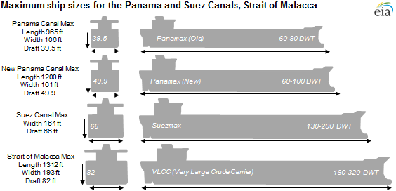
For those that do not know, ships are built to maximum size to fit through the Panama and Suez canals. With the new panama canal locks opened, that has resulted in a new class of ship, Neopanamax, and now it is up to the ports to accomodate these larger vessels.
these are different sizes for tankers, but bulk carriers, general cargo, and containerships are all built in similar size categories.
quote:
Today, Gov. John Bel Edwards and other top Louisiana officials signed a formal agreement with the U.S. Army Corps of Engineers to begin construction on the deepening of the Lower Mississippi River to 50 feet from 45 feet. This project will provide deep draft access to the ports at Baton Rouge, New Orleans, South Louisiana, St. Bernard and Plaquemines.
quote:
“When completed, this project will allow larger vessels that can currently use the widened Panama Canal to reach Louisiana ports as far north as Baton Rouge. It will also allow for some vessels to carry heavier loads
I know pilot salaries are the hot topic of the day, but that represents a very small portion of the costs to ship goods. as ships continue to be built bigger, deepwater access is the real issue that determines the lower Mississippi's competitiveness, as a port, with other gulf coast and even east coast ports.
ever since the new Panama Canal locks were opened, there has been a race to 50 feet among gulf coast and east coast ports including the lower mississippi (Port Nola, Port of Baton Rouge, Port of South Louisiana) Houston, Mobile, etc.
For those that do not know, ships are built to maximum size to fit through the Panama and Suez canals. With the new panama canal locks opened, that has resulted in a new class of ship, Neopanamax, and now it is up to the ports to accomodate these larger vessels.
these are different sizes for tankers, but bulk carriers, general cargo, and containerships are all built in similar size categories.
quote:
“With the signing today, we have taken one step forward toward providing a better future for countless Louisianans,” said DOTD Secretary Shawn Wilson, Ph.D. “If we work together with our natural resources and put a multimodal commerce plan in place, the Mississippi River can be an economic super highway and Louisiana can be a leader in global goods movement.
 25
25

Posted on 8/1/20 at 12:07 pm to Captain Crackysack
Good. We have no topography, we need to dredge every river in the state.

Posted on 8/1/20 at 12:08 pm to Captain Crackysack
I just hope one of those big bastards doesn’t hit the levee during flood stage.
This post was edited on 8/1/20 at 12:24 pm

Posted on 8/1/20 at 12:08 pm to Captain Crackysack
Good news. Amazing what a difference a couple feet makes.

Posted on 8/1/20 at 12:09 pm to Captain Crackysack
I’m gonna need several, multi-year studies on environmental impacts before they move forward with this.

Posted on 8/1/20 at 12:09 pm to Captain Crackysack
quote:
I know pilot salaries are the hot topic of the day, but that represents a very small portion of the costs to ship goods
I thought this wasn’t a river pilot thread?

Posted on 8/1/20 at 12:09 pm to Captain Crackysack
quote:
to 50 feet from 45 feet.
Seems like a small change. I feel like the river bottom could frequently vary that much due to silt. But I'm not a river scientist.
Posted on 8/1/20 at 12:11 pm to Red Stick Rambler
It's not. But I'm sure it'll turn into one anyway. Fact of the matter is, it can cost $800,000+ in tariff fees just to get a neopanamax thru the canal so pilot fees are not the biggest concern for these shipping companies
Posted on 8/1/20 at 12:14 pm to wheelr
The USACE already has constant dredging operations underway to maintain 45 feet. This will just result in expanded dredging operations

Posted on 8/1/20 at 12:15 pm to High C
quote:You say that like you’re joking...
I’m gonna need several, multi-year studies on environmental impacts before they move forward with this.
Posted on 8/1/20 at 12:18 pm to Captain Crackysack
quote:
The USACE already has constant dredging operations underway to maintain 45 feet. This will just result in expanded dredging operations
Thanks.
Why is it a new project? Couldn't they just start going deeper during their routine operations?
Posted on 8/1/20 at 12:18 pm to Captain Crackysack
What kind of mileage of river are we talking? That sounds like a huge undertaking.
Posted on 8/1/20 at 12:21 pm to Captain Crackysack
Pretty interesting!
Posted on 8/1/20 at 12:24 pm to jimbeam
quote:
You say that like you’re joking...
More being sarcastic, but yeah.
Posted on 8/1/20 at 12:29 pm to wheelr
The USACE currently maintains a "navigable channel" of 45ft depth and 750ft width. There are sections that are less than 45 ft deep but as long as there is a 750ft wide section that is 45 then it is not dredged.
There are also large sections of the river that are already much deeper than 45 feet. This project won't result in the entire 250ish miles from SW Pass to BR being dredged, just the sections necessary to provide a minimum depth of 50 ft along the entire route
There are also large sections of the river that are already much deeper than 45 feet. This project won't result in the entire 250ish miles from SW Pass to BR being dredged, just the sections necessary to provide a minimum depth of 50 ft along the entire route

Posted on 8/1/20 at 12:29 pm to Captain Crackysack
Where are they dumping the sediment? Hopefully in the swamps.
Posted on 8/1/20 at 12:30 pm to Captain Crackysack
quote:
This will just result in expanded dredging operations
And more opportunities to use that silt to build land and restore marsh. If they will do that, as opposed to dumping it in the damn ocean.

Posted on 8/1/20 at 12:31 pm to Captain Crackysack
Panama Canal Max: Panamax (old)
New Panama Canal Max: Panamax (new)
Suez Canal Max: Suezmax
Straight of Malacca Max: Very Large Crude Carrier (VLCC)
This amuses me
This post was edited on 8/1/20 at 12:32 pm
Posted on 8/1/20 at 12:31 pm to Stealth Matrix
The sediment from the first 30 mile section of river will be used for wetlands restoration. The rest of it will probably just be released into the water column and let the river take it away
Posted on 8/1/20 at 12:33 pm to Captain Crackysack
They should load the silt from this project onto barges and start another project for coastal restoration

 Page 1 of 4

Popular
Back to top