- My Forums
- Tiger Rant
- LSU Recruiting
- SEC Rant
- Saints Talk
- Pelicans Talk
- More Sports Board
- Fantasy Sports
- Golf Board
- Soccer Board
- O-T Lounge
- Tech Board
- Home/Garden Board
- Outdoor Board
- Health/Fitness Board
- Movie/TV Board
- Book Board
- Music Board
- Political Talk
- Money Talk
- Fark Board
- Gaming Board
- Travel Board
- Food/Drink Board
- Ticket Exchange
- TD Help Board
Customize My Forums- View All Forums
- Show Left Links
- Topic Sort Options
- Trending Topics
- Recent Topics
- Active Topics
Started By
Message
 3
3

Posted on 3/6/19 at 11:07 am to TDsngumbo
quote:
GFS shows about 50/50 below freezing temps and well above freezing temps for the central/northern plains as well as the Ohio River valley over the next two weeks. Combined with more rain, the snow will start to melt then refreeze then melt again.
Thanks for keeping the thread updated!
I cant believe the river is going to drop that fast after March 15th. There is a lot of snow and ice dams to release up north.

Posted on 3/6/19 at 11:23 am to FelicianaTigerfan
quote:
There are pics going around of a levee slide up around deer park near Blackhawk. Ill see if I can get them posted
This is what you're talking about. Some are saying these pics are old and the levee has been repaired since then but then others are saying they saw this very recently and it hasn't been repaired. It's important to remember than during times like this, rumors fly abundantly. Are these pics recent? The facebook post they're from is from late February. Does that mean the pictures were taken then? No way to tell.
I hesitated to post these in this thread because they haven't been confirmed, but the "slide" in these pictures is exactly what others here have stated is a concern due to all the rain and soggy conditions across south Louisiana.


Posted on 3/6/19 at 11:26 am to Mudminnow
quote:
I cant believe the river is going to drop that fast after March 15th. There is a lot of snow and ice dams to release up north.
With them unable to accurately predict when that melts, and unable to accurately predict rainfall amounts, those things cant be factored into what the river will do that far out. That big drop is the prediction with no rainfall or snow melt past 48 hrs
Posted on 3/6/19 at 11:29 am to FelicianaTigerfan
quote:
There are pics going around of a levee slide up around deer park near Blackhawk. Ill see if I can get them posted
There were slides in 2016.
USACE Video of Slides Near Deer Park
Posted on 3/6/19 at 11:32 am to JudgeHolden
That video shows the top of the slide a bit further away from the top of the levee than in the pics posted. So either this is a new slide or the same slide, just photographed at a further stage than what is shown in that video. Also, the river looks higher up the levee in the pics than in that video.
Posted on 3/6/19 at 11:34 am to TDsngumbo
quote:
That video shows the top of the slide a bit further away from the top of the levee than in the pics posted. So either this is a new slide or the same slide, just photographed at a further stage than what is shown in that video. Also, the river looks higher up the levee in the pics than in that video.
Got it. I ain't no hydrologist, but it seems to me that the hydraulic force on the levees at Deer Park would be relatively low. The river bends the other way, and there is a lot of shallow, wooded land between the main channel and the levee.
ETA: The baws on the Outdoor Board seem to think these are old pics.
LINK
This post was edited on 3/6/19 at 11:40 am
Posted on 3/6/19 at 11:41 am to FelicianaTigerfan
quote:
There are pics going around of a levee slide up around deer park near Blackhawk. Ill see if I can get them posted
I passed there yesterday and water was higher up the levee, and there were no corp or construction vehicles to indicate a fix was needed (which I assume they'd be working on, even on Fat Tuesday). I'd go with old pics.
Yesterday's forecast was up .5' but still no reason to believe they'll open Morganza. Old River Control structure had about 9 gates open (shorter structure) and water that was being pumped was volatile, to say the least. Longer structure had more gates open, with more of a steady flow.
Posted on 3/6/19 at 11:45 am to lsuKountRy
quote:
Old River Control structure had about 9 gates open (shorter structure) and water that was being pumped was volatile, to say the least
It really is something to see.
Posted on 3/6/19 at 12:25 pm to DeCat ODahouse
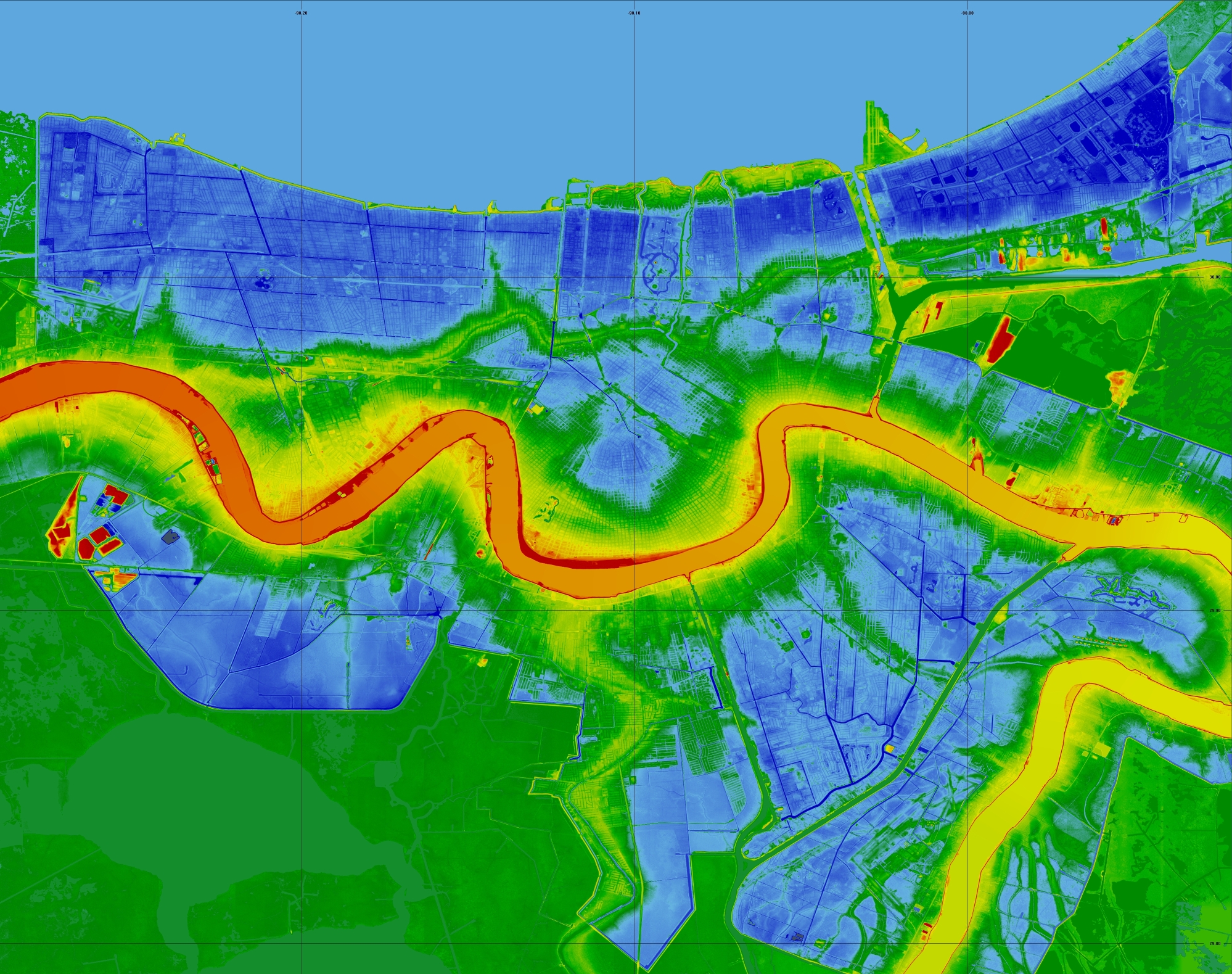
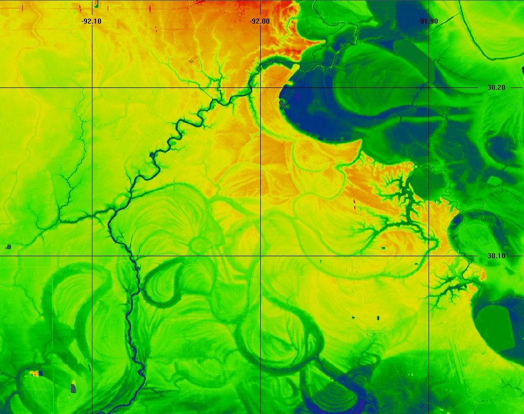
This map comes from a MR. David Lynch with cdly.org, who apparently worked with USGS.
He has separate maps for various metro areas in the US -- though mainly focused around Louisiana. Pretty cool shite.
New Orleans - Blue areas are below sea level (colors darken with increasing depth).
Lafayette - at top center.
He has separate maps for various metro areas in the US -- though mainly focused around Louisiana. Pretty cool shite.
New Orleans - Blue areas are below sea level (colors darken with increasing depth).
Lafayette - at top center.
Posted on 3/6/19 at 3:33 pm to TDsngumbo
So far as establishing a date on the Deer Park pics, would any vegetation in Illinois be green at this time of year?
Posted on 3/6/19 at 3:35 pm to FeauxPaw


Posted on 3/6/19 at 3:38 pm to lsuKountRy
quote:
Yesterday's forecast was up .5' but still no reason to believe they'll open Morganza
quote:
water that was being pumped
Pumped? Huh?
Posted on 3/6/19 at 3:40 pm to MrLSU
Posted on 3/6/19 at 4:17 pm to DeCat ODahouse
quote:
Deer Park
Dats in La baw

Posted on 3/6/19 at 4:45 pm to FelicianaTigerfan
The river got to 43.28 in January 2016 and there was serious talk of them having to open Morganza. It’s predicted to get to 44 this time and all the officials seem to be pretty dismissive of the possibility. The difference in reaction to this event is interesting.
They’re predicting the third highest crest on record at Red River Landing at 61.5. It was 60.71 in January 2016.
They’re predicting the third highest crest on record at Red River Landing at 61.5. It was 60.71 in January 2016.
Posted on 3/6/19 at 4:51 pm to FelicianaTigerfan
I think to open Morgana spillway, river has to get above 44.5'. Don't bank on that number. Past that way yesterday and the water in the farbay is super high.
Posted on 3/6/19 at 4:53 pm to fishfighter
It has to do with the rate of flow. 1.5 million cubic feet per second. Strange the flow rate would be so much different than 2016.
Posted on 3/6/19 at 5:30 pm to lsuKountRy
I drive by that area daily. The pics of the slide are recent as I looked at it yesterday while checking wells. The slide is about 1 mile North of LDWF headquarters at Shaw. Only about 1/4 mile south of the large sand boil in borrow pit on land side that had USACE haul several thousand tons of dirt and Limestone in to stop the flow last year.Currently clearing timber along borrow pit to drill relief wells to direct water flow to surface. By drilling the wells USACE are trying to prevent the seepage under the levee from moving material
Posted on 3/6/19 at 5:34 pm to The Boat
quote:
It has to do with the rate of flow. 1.5 million cubic feet per second. Strange the flow rate would be so much different than 2016.
Once the ice dams release on the Missouri and additional snow melt. Giddy up!

 Page 31 of 107

Popular
Back to top