- My Forums
- Tiger Rant
- LSU Recruiting
- SEC Rant
- Saints Talk
- Pelicans Talk
- More Sports Board
- Fantasy Sports
- Golf Board
- Soccer Board
- O-T Lounge
- Tech Board
- Home/Garden Board
- Outdoor Board
- Health/Fitness Board
- Movie/TV Board
- Book Board
- Music Board
- Political Talk
- Money Talk
- Fark Board
- Gaming Board
- Travel Board
- Food/Drink Board
- Ticket Exchange
- TD Help Board
Customize My Forums- View All Forums
- Show Left Links
- Topic Sort Options
- Trending Topics
- Recent Topics
- Active Topics
Started By
Message


 1
1

Posted on 2/28/23 at 9:55 pm to Bobby OG Johnson
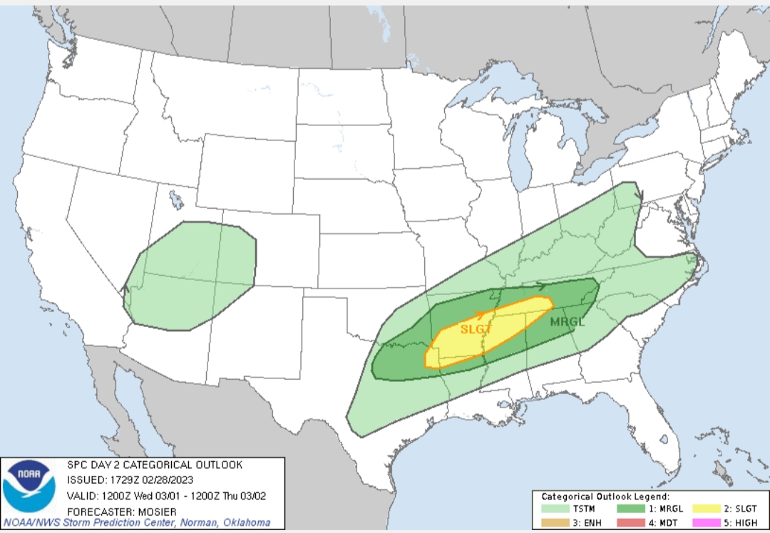
Might as well post the Day 2 outlook for the AL/MS/AR folks.
quote:
Day 2 Convective Outlook NWS Storm Prediction Center Norman OK 1129 AM CST Tue Feb 28 2023
Valid 011200Z - 021200Z
...THERE IS A SLIGHT RISK OF SEVERE THUNDERSTORMS FROM THE ARKLATEX ACROSS THE MID-SOUTH INTO MIDDLE TN...
...SUMMARY... Severe thunderstorms will be possible on Wednesday from northeast Texas through the Mid-South and into Middle Tennessee, with a threat of hail, damaging wind, and a couple of tornadoes.
...Synopsis... The strong shortwave trough currently just off the Pacific Northwest coast is expected to drop south through northern CA today, before then pivoting more eastward/southeastward as it moves from central CA through the southern Great Basin/Lower CO River Valley and AZ. By early Thursday, this shortwave, which will likely have matured into a closed low, is expected to be centered over the AZ/NM border. Enhanced southwesterly mid-level flow will precede this system, extending from the southern High Plains across much of the eastern CONUS. Most guidance indicates a low-amplitude shortwave trough will move through this southwesterly flow aloft, progressing from the southern High Plains through the southern and central Plains Wednesday.
At the surface, a low will likely be centered over southwest MO. A cold front will extend southwestward from this low through eastern OK and north-central TX. This low is expected to progress northeastward through the OH Valley during the day, while the cold front remains largely stationary. This boundary will eventually begin returning northward Wednesday evening through Thursday morning as surface cyclogenesis occurs over the southern High Plains and the low-level flow increases across the southern Plains.
...North TX through the Arklatex into the Mid-South/TN Valley... Despite a notable mid-level dry layer, convergence along the front coupled with modest large-scale ascent attendant to the lead shortwave may result in isolated thunderstorms Wednesday morning over north-central TX. Primary threat with this activity would be hail. Timing and coverage varies within the guidance, precluding higher probabilities with this outlook.
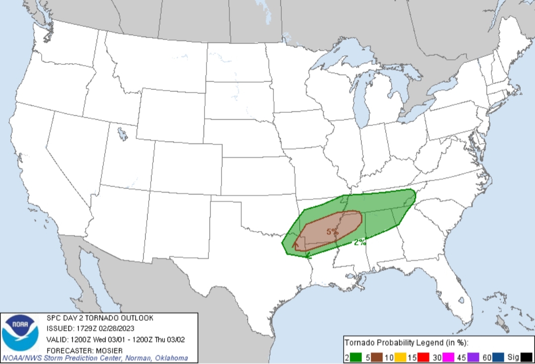
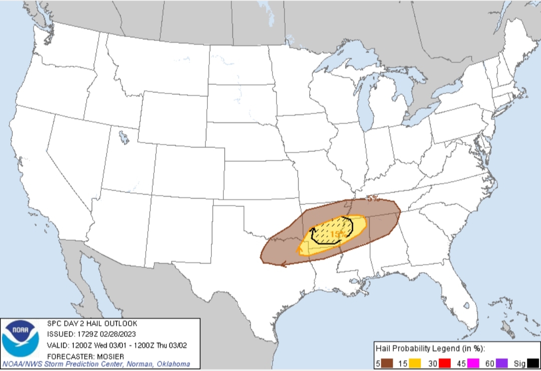
Farther east (from northeast TX/Arklatex into the Mid-South), thunderstorms are expected to develop in the vicinity of the front Wednesday afternoon into Wednesday evening, supported by lift from persistent low-level convergence and the subtle shortwave trough. Storm initiation appears most probable in the Arklatex with storms then potentially maturing across southern AR and far northwest MS. Long hodographs suggest splitting supercells capable of all severe hazards are possible with the mature warm sector storms, including very large hail and tornadoes. Modest ascent results in uncertainty regarding storm coverage within the warm sector.
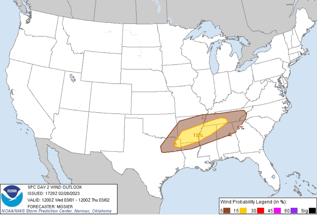
Greater storm coverage is anticipated north of the front, where hail will still be possible, particularly with early development. A trend towards a more linear mode, with one or more bowing segments, is expected over time along and north the front. Potential exists for these more linear storms to encounter less low-level stability farther with eastern extent, increasing the potential for damaging wind gusts from northern MS into Middle TN.
..Mosier.. 02/28/2023
This post was edited on 2/28/23 at 9:58 pm

 Page 1 of 1


Popular
Back to top