- My Forums
- Tiger Rant
- LSU Recruiting
- SEC Rant
- Saints Talk
- Pelicans Talk
- More Sports Board
- Fantasy Sports
- Golf Board
- Soccer Board
- O-T Lounge
- Tech Board
- Home/Garden Board
- Outdoor Board
- Health/Fitness Board
- Movie/TV Board
- Book Board
- Music Board
- Political Talk
- Money Talk
- Fark Board
- Gaming Board
- Travel Board
- Food/Drink Board
- Ticket Exchange
- TD Help Board
Customize My Forums- View All Forums
- Show Left Links
- Topic Sort Options
- Trending Topics
- Recent Topics
- Active Topics
Started By
Message
re: How many of you baws went to the public meeting last night about the new bridge?
Posted on 4/26/22 at 11:38 am to tigerinthebueche

Posted on 4/26/22 at 11:38 am to tigerinthebueche
quote:
Is she wrong? If the majority of the traffic is trying to get to I12, she has a point.
No, she's not but I think you misunderstood her or didn't read her actual quote.
quote:
Eits said lots of traffic on the current bridge near Port Allen, especially 18-wheelers, is trying to get to I-12 on the way east and those drivers want to avoid New Orleans.
The majority of semis are indeed going to 12, anyone can see this any afternoon as the majority of semis stick to the three inner lanes at the 10-12 split going east.
While a lot of smaller traffic goes the same direction, the real problem on 12 comes in with Essen and 10 being major routes for traffic onto 12 east, both being very near to each other and the traffic is compensated for with only short, temporary 4th lanes.
To add to this, a lot of traffic comes on at Airline as well and it's clover-leaf aspect means the outside lane becomes a massive clusterfrick as a high amount of traffic attempting to enter the interstate have to jockey with a high amount of traffic attempting to exit the interstate, all in a very small amount of space. Then just beyond that is the other entrance from Airline to the interstate (the northbound Airline traffic).
Where a bridge would be most effective is Option 1 (this is a bit farther south than the previous one, which was between Brusly and Addis).
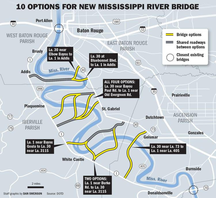
The idea is that it should be the crossing point for a southern loop, where passthrough traffic could go to avoid coming into Baton Rouge altogether.

The yellow line is about where I would like to see the loop go with the current option. The purple line is where the previous northernmost choice was. Part of the key to this is having Hwy 30 four (ideally six) laned from the bridge up to LSU's campus in order to provide a large, new avenue for that population to pull a lot of that traffic from the center of the city as well. A loop like either of those would be the primary route any east-west traffic bound for New Orleans would take as well as open up more area for population growth BEFORE it gets there, create a new avenue for plant traffic (which takes it out of Baton Rouge) and adds only a few extra miles to any trip for those passing through the area entirely.
 2
2

Posted on 4/26/22 at 12:11 pm to Bard
Neither of the by-pass routes you drew in are viable.
They aren’t going to build a highway through major subdivisions
They aren’t going to build a highway through major subdivisions
Posted on 4/26/22 at 12:31 pm to Bard
quote:
he yellow line is about where I would like to see the loop go with the current option.
drop that yellow line just a little bit and you can go straight through/over the swamp. Boggles my little brain why this path for a bypass/bridge doesn't show up on any of the suggestions/options. I used the Google thingy to measure distance and it's only 23 miles total. It's about 21 miles taking I-10. Don't take a DOTD Traffic engineer to figure out people would gladly drive an extra 3 miles to save an hour in traffic. And an I-10 Interchange at/near Bluff Road has been discussed anyhow. Makes too much sense I suppose. The bend in the river is the only thing that I would imagine prevents a bridge going there. Build a tunnel maybe(It's pretty narrow there)?

This post was edited on 4/26/22 at 6:36 pm

 Page 1 of 1


Popular
Back to top