- My Forums
- Tiger Rant
- LSU Recruiting
- SEC Rant
- Saints Talk
- Pelicans Talk
- More Sports Board
- Coaching Changes
- Fantasy Sports
- Golf Board
- Soccer Board
- O-T Lounge
- Tech Board
- Home/Garden Board
- Outdoor Board
- Health/Fitness Board
- Movie/TV Board
- Book Board
- Music Board
- Political Talk
- Money Talk
- Fark Board
- Gaming Board
- Travel Board
- Food/Drink Board
- Ticket Exchange
- TD Help Board
Customize My Forums- View All Forums
- Show Left Links
- Topic Sort Options
- Trending Topics
- Recent Topics
- Active Topics
Started By
Message
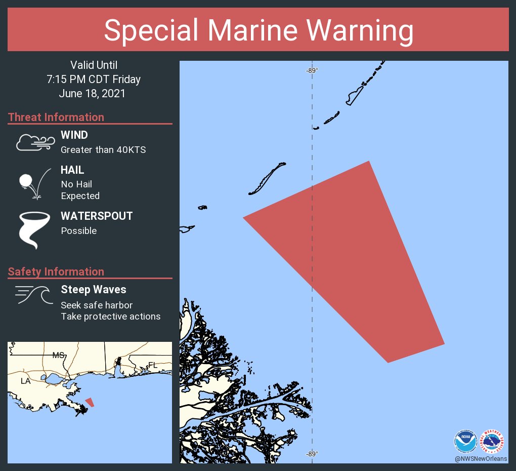
re: Tropical Storm Claudette - Heading Out Sea
Posted on 6/18/21 at 6:33 pm to Bobby OG Johnson

Posted on 6/18/21 at 6:33 pm to Bobby OG Johnson

 3
3

Posted on 6/18/21 at 6:37 pm to Hulkklogan
1 mile due East of Death Valley
Posted on 6/18/21 at 6:37 pm to tigahfan747
quote:
Looks like NOLA metro could get some heavy rains starting around 8:30PM until around midnight. Starting to get pretty gusty around here right now.
Down here in God's country, St. Bernard, have had a few decent rain bands. Nothing crazy.
Just got the update that there will still be travel ball down here tomorrow, so the O-T can rest easy!

Posted on 6/18/21 at 6:39 pm to Bobby OG Johnson
Rain has stopped in Maurepas. Nice cool breeze out of the NE.
Hope the fish will be biting once the water starts rolling back south.
Hope the fish will be biting once the water starts rolling back south.
Posted on 6/18/21 at 6:42 pm to Bobby OG Johnson
Closedish, and it's moving mostly north and has some north wind. Probably enough to call it, as much of a mess as it is.
ETA: NHC doesn't pull the trigger.
ETA: NHC doesn't pull the trigger.
This post was edited on 6/18/21 at 6:46 pm
Posted on 6/18/21 at 6:47 pm to Duke
7 p.m. advisory out
NHC says the center still not on land.
Rain pretty much light over the bayou area. Actually looking at the floodgates in Terrebonne. Winds are blowing out the NE and water is starting to fall.
000
WTNT33 KNHC 182339
TCPAT3
BULLETIN
Potential Tropical Cyclone Three Intermediate Advisory Number 5A
NWS National Hurricane Center Miami FL AL032021
700 PM CDT Fri Jun 18 2021
...DISTURBANCE APPROACHING THE NORTH-CENTRAL GULF COAST...
...HEAVY RAINFALL AND TROPICAL-STORM-FORCE WINDS CONTINUING TO
SPREAD ACROSS THE REGION...
SUMMARY OF 700 PM CDT...0000 UTC...INFORMATION
----------------------------------------------
LOCATION...28.3N 91.1W
ABOUT 100 MI...160 KM S OF MORGAN CITY LOUISIANA
ABOUT 260 MI...420 KM SW OF MOBILE ALABAMA
MAXIMUM SUSTAINED WINDS...45 MPH...75 KM/H
PRESENT MOVEMENT...N OR 5 DEGREES AT 16 MPH...26 KM/H
MINIMUM CENTRAL PRESSURE...1007 MB...29.74 INCHES
WATCHES AND WARNINGS
--------------------
CHANGES WITH THIS ADVISORY:
None.
SUMMARY OF WATCHES AND WARNINGS IN EFFECT:
A Tropical Storm Warning is in effect for...
* East of Morgan City, Louisiana to the Okaloosa/Walton County line
Florida.
* Lake Pontchartrain, Lake Maurepas, and Metropolitan New Orleans
A Tropical Storm Warning means that tropical storm conditions are
expected somewhere within the warning area, in this case within the
next 6-12 hours.
Interests elsewhere along the northern Gulf Coast should monitor
the progress of this system.
For storm information specific to your area, including possible
inland watches and warnings, please monitor products issued by your
local National Weather Service forecast office.
DISCUSSION AND OUTLOOK
----------------------
At 700 PM CDT (0000 UTC), the disturbance was centered near latitude
28.3 North, longitude 91.1 West. The system is moving toward the
north near 16 mph (26 km/h) and a north to north-northeast motion is
expected during the next day or so. On the forecast track, the
system will make landfall along the north-central Gulf Coast tonight
or early Saturday. A northeastward or east-northeastward motion
across the southeastern United States is forecast after landfall
through the weekend.
Maximum sustained winds are near 45 mph (75 km/h) with higher
gusts. Satellite images and surface observations indicate that the
circulation is slowly becoming better defined, and the system still
is likely to become a tropical or subtropical storm before landfall.
Regardless of its status, little change in strength is expected
through landfall. Weakening is forecast to begin after the system
crosses the coast.
* Formation chance through 48 hours...high ...90 percent.
* Formation chance through 5 days...high...90 percent.
Tropical-storm-force winds extend outward up to 205 miles (335 km)
mainly to the east of the center. An oil rig south of the
southeastern coast of Louisiana recently reported sustained winds of
44 mph (70 km/h) and a wind gust of 58 mph (93 km/h).
The estimated minimum central pressure based on surface
observations and Air Force Hurricane Hunter data is 1007 mb (29.74
inches).
HAZARDS AFFECTING LAND
----------------------
Key messages for Potential Tropical Cyclone Three can be found in
the Tropical Cyclone Discussion under AWIPS header MIATCDAT3,
WMO header WTNT43 KNHC, and on the web at
www.hurricanes.gov/graphics_at3.shtml?key_messages.
RAINFALL: The potential tropical cyclone is expected to produce
rainfall totals of 4 to 8 inches with isolated maximum amounts of 12
inches across portions of the Central Gulf Coast. Considerable
flash, urban and small stream flooding impacts as well as new and
renewed minor to isolated moderate river flooding are likely.
As the system continues to lift northeast through the weekend, heavy
rain will expand across southeastern Mississippi, southern and
central Alabama, central to northern Georgia, far western North
Carolina and western South Carolina, resulting in rainfall totals of
3 to 5 inches with isolated maximum amounts of 7 inches. Flash,
urban, small stream and isolated minor river flooding impacts are
possible.
STORM SURGE: The combination of storm surge and the tide will
cause normally dry areas near the coast to be flooded by rising
waters moving inland from the shoreline. The water could reach the
following heights above ground somewhere in the indicated areas if
the peak surge occurs at the time of high tide...
Morgan City, LA to Okaloosa/Walton County Line, FL...2-3 ft
Lake Borgne and Mobile Bay...2-3 ft
Lake Pontchartrain and Lake Maurepas...1-2 ft
Okaloosa/Walton County Line, FL to Panama City, FL...1-2 ft
Pensacola Bay, Choctawhatchee Bay, and Saint Andrew Bay...1-2 ft
Cameron, LA to Morgan City, LA...1-2 ft
Vermilion Bay...1-2 ft
Surge-related flooding depends on the relative timing of the surge
and the tidal cycle, and can vary greatly over short distances. For
information specific to your area, please see products issued by
your local National Weather Service forecast office.
WIND: Tropical storm conditions are beginning to reach the coast
within the warning area, and these winds will continue into
Saturday.
TORNADOES: There is a threat for a tornado or two tonight
across coastal Louisiana. A few tornadoes are possible on
Saturday across southern portions of Louisiana, Mississippi,
Alabama, and the western Florida Panhandle.
NEXT ADVISORY
-------------
Next complete advisory at 1000 PM CDT.
$$
Forecaster Beven
Posted on 6/18/21 at 6:50 pm to Bobby OG Johnson
Posted on 6/18/21 at 6:51 pm to Duke
quote:
ETA: NHC doesn't pull the trigger.
Reckon they thought it was too messy
Posted on 6/18/21 at 6:52 pm to Bobby OG Johnson
I agree, but I could see an argument and figured with it this close to land they'd probably just name it.
Good on them for sticking with the PTC.
Good on them for sticking with the PTC.

Posted on 6/18/21 at 6:54 pm to CitizenK
I'm not that far away. 1 mi north of i10 on college.
Posted on 6/18/21 at 7:01 pm to Bobby OG Johnson
I hope this remains just potential, and comes onshore nameless to piss off the weather channel.

Posted on 6/18/21 at 7:13 pm to LSUneaux
Still far offshore and the rain is about to leave New Orleans
Whisper softly in my ear, June “storm”
Whisper softly in my ear, June “storm”

Posted on 6/18/21 at 7:14 pm to The Boat
Tell me good things for my drive to the gulf in the morning
Posted on 6/18/21 at 7:19 pm to The Boat
Naked swirl was left behind in the Gulf
Posted on 6/18/21 at 7:22 pm to NorthEndZone
quote:
Naked swirl
Might need to add to the bingo cards
Posted on 6/18/21 at 7:22 pm to NorthEndZone
quote:
Naked swirl was left behind in the Gulf
like Marco last year where the LLC made landfall in Plaquemines Parish but all the rain was in Alabama
Posted on 6/18/21 at 7:24 pm to hg
quote:
Tell me good things for my drive to the gulf in the morning
Good things.
In all seriousness, may be some lingering showers but I'm not thinking anything intense by tomorrow morning.

Posted on 6/18/21 at 7:26 pm to hg
You’re going to drown
Posted on 6/18/21 at 7:29 pm to hg
quote:
Tell me good things for my drive to the gulf in the morning
Roll your windows up.
 ...
... Posted on 6/18/21 at 7:32 pm to Duke
If NHC names this before landfall they have officially turned the frogs gay

 Page 60 of 72

Popular
Back to top