- My Forums
- Tiger Rant
- LSU Recruiting
- SEC Rant
- Saints Talk
- Pelicans Talk
- More Sports Board
- Fantasy Sports
- Golf Board
- Soccer Board
- O-T Lounge
- Tech Board
- Home/Garden Board
- Outdoor Board
- Health/Fitness Board
- Movie/TV Board
- Book Board
- Music Board
- Political Talk
- Money Talk
- Fark Board
- Gaming Board
- Travel Board
- Food/Drink Board
- Ticket Exchange
- TD Help Board
Customize My Forums- View All Forums
- Show Left Links
- Topic Sort Options
- Trending Topics
- Recent Topics
- Active Topics
Started By
Message
re: Storm Watch- Gulf- Tropical Depression- Northward Miss. Valley
Posted on 6/6/20 at 9:02 pm to Roll Tide Ravens

Posted on 6/6/20 at 9:02 pm to Roll Tide Ravens
quote:
the heaviest rain bands ... well east of the center.
typical for a TS
 2
2

Posted on 6/6/20 at 9:06 pm to East Coast Band
Monsoon Gyre is what Levi called the broad rotation that the actual storm rotation kind of got swallowed by.

Posted on 6/6/20 at 9:07 pm to Duke
Just seeing if I can get this radar loop to post correctly (for future use). Looks like it worked. Hopefully it doesn't slow the page way down.
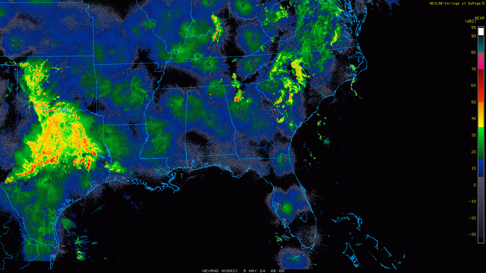
This post was edited on 6/6/20 at 9:13 pm
Posted on 6/6/20 at 9:08 pm to rt3
quote:
That's flight level winds, need to extrapolate for surface winds.
quote:
ah my bad... I knew that
You know someone had to do it. It is usually Jeff Pietrowski showing the radar and saying, "I'm getting 200mph winds!"
Posted on 6/6/20 at 9:09 pm to Roll Tide Ravens
It posted. The rest of the country looks weird, though.
Posted on 6/6/20 at 9:10 pm to LegendInMyMind
quote:
It posted. The rest of the country looks weird, though.
Thanks for the confirmation. It is a composite of all of the NEXRAD radar sites in the country (though I have it zoomed to a specific region). So what you're seeing from most of the sites elsewhere is just ground return/clutter.
This post was edited on 6/6/20 at 9:12 pm

Posted on 6/6/20 at 9:11 pm to LegendInMyMind
quote:
You know someone had to do it. It is usually Jeff Pietrowski showing the radar and saying, "I'm getting 200mph winds!"
I hate Jeff.
His streams are awful outside of that one for Hurricane Harvey. BYAHH BYAAHH I GOT 145 MPH winds.. Looks around.. trees barely moving.
Posted on 6/6/20 at 9:11 pm to slackster
Jen Carfagno by A MILE!!!!!!!!!!!!!!
Yup. She is a MILF babe
Yup. She is a MILF babe
Posted on 6/6/20 at 9:11 pm to Roll Tide Ravens
Somewhat msleading for it doesn't pick up the rain out in the middle of the GOM
Posted on 6/6/20 at 9:14 pm to Armymann50
Catfish cleaned.
Three quarters of the way drunk.
White beans and rice,corn bread muffins and fish that were swimming a couple of hours ago.
Not enough rain to go through a slicker suit.
When it is supposed to blow?
Three quarters of the way drunk.
White beans and rice,corn bread muffins and fish that were swimming a couple of hours ago.
Not enough rain to go through a slicker suit.
When it is supposed to blow?
Posted on 6/6/20 at 9:15 pm to Bronsonburner
Alex Wilson >>>>>>
Why do they have her stuck in the studio? They should have her out in Baton Rouge for this one. I’d take her to Fred’s.
Why do they have her stuck in the studio? They should have her out in Baton Rouge for this one. I’d take her to Fred’s.

Posted on 6/6/20 at 9:16 pm to Bigfishchoupique
Enjoy your food. Outside coastal flooding this boi is a bust.
Posted on 6/6/20 at 9:19 pm to The Boat
quote:
the strongest winds off to the east of the center that will bring the strongest winds into the New Orleans area.
If you look at the wind map below, the strongest winds are at least 1 whole degree up to almost 2 degrees of latitude east of the LLC. That is about 60 miles to 120 miles which is about the difference between Houma and New Orleans and Houma and Gulfport/Biloxi.

This post was edited on 6/6/20 at 9:20 pm
Posted on 6/6/20 at 9:20 pm to NorthEndZone
quote:
That is about 60 miles to 120 miles which is about the difference between Houma and New Orleans and Houma and Gulfport/Biloxi.
Yeah it’s gonna make landfall around Houma and come up through Baton Rouge.

This post was edited on 6/6/20 at 9:23 pm
Posted on 6/6/20 at 9:22 pm to East Coast Band
quote:
typical for a TS
It almost has a subtropical storm/cyclone look to it.
Posted on 6/6/20 at 9:25 pm to NorthEndZone
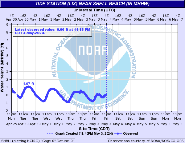
Shell Beach water level is not dropping with the normal lunar tide. Not a good sign for the next high tide tomorrow.

Posted on 6/6/20 at 9:27 pm to Bigfishchoupique
quote:fork and knife at the ready.
White beans and rice,corn bread muffins and fish
Posted on 6/6/20 at 9:27 pm to NorthEndZone
Shell Beach reached 9.36 feet during Hurricane Isaac.
Posted on 6/6/20 at 9:28 pm to Roll Tide Ravens
It does look subtropical today but this was also expected. Dry air working in on the east side between the center and the big band that blew up near Florida.
The thought is overnight and into tomorrow it cuts the dry air off from the center and gets more tropical looking as it approaches landfall.
Fortunately, with very little time to take advantage of it's better situation, the winds shouldn't increase much and still going to be right sided.
The thought is overnight and into tomorrow it cuts the dry air off from the center and gets more tropical looking as it approaches landfall.
Fortunately, with very little time to take advantage of it's better situation, the winds shouldn't increase much and still going to be right sided.
Posted on 6/6/20 at 9:28 pm to The Boat
quote:I believe it.
Hurricane Isaac.
This post was edited on 6/6/20 at 9:31 pm

 Page 71 of 107

Back to top