- My Forums
- Tiger Rant
- LSU Recruiting
- SEC Rant
- Saints Talk
- Pelicans Talk
- More Sports Board
- Coaching Changes
- Fantasy Sports
- Golf Board
- Soccer Board
- O-T Lounge
- Tech Board
- Home/Garden Board
- Outdoor Board
- Health/Fitness Board
- Movie/TV Board
- Book Board
- Music Board
- Political Talk
- Money Talk
- Fark Board
- Gaming Board
- Travel Board
- Food/Drink Board
- Ticket Exchange
- TD Help Board
Customize My Forums- View All Forums
- Show Left Links
- Topic Sort Options
- Trending Topics
- Recent Topics
- Active Topics
Started By
Message
re: Severe weather threat continues today for parts of the southeast - Threat is Over.
Posted on 3/16/21 at 11:31 pm to Strannix

Posted on 3/16/21 at 11:31 pm to Strannix
quote:
As a 40-50 kt low level jet increases around 00-03z, intense supercells are expected to advance eastward along with the cold front across MS and into AL overnight. This will bring a second round of significant severe storms capable of intense tornadoes, large hail and intense damaging winds across much of MS/AL. If these trends are maintained, an upgrade to a High risk could be necessary with the initial Day 1 Convective Outlook at 06z tonight.
This night is mine.
It’s only you and I.
Tomorrow is such a long time away.
This night can last forever.
 0
0


Posted on 3/16/21 at 11:43 pm to rds dc
The latest HRRR agrees with you. Messy AF.
Posted on 3/16/21 at 11:44 pm to Roll Tide Ravens
will i be able to play golf in NO early wed morning???

Posted on 3/16/21 at 11:58 pm to lsuoilengr
quote:
will i be able to play golf in NO early wed morning???

Posted on 3/17/21 at 12:55 am to red sox fan 13
HIGH RISK

This post was edited on 3/17/21 at 1:00 am
Posted on 3/17/21 at 1:03 am to GEAUXmedic
Change the threat level to Code Brown in Central Mississippi, because I’d be shitting my pants right about now if I lived there.
Posted on 3/17/21 at 1:22 am to GEAUXmedic
Didn’t want to see the high risk tickling my fanny

Posted on 3/17/21 at 2:49 am to GEAUXmedic
shite I'm really concerned about family and friends in that area tomorrow. I picked the right week to go snowboarding, but hope I don't come home to my place destroyed.

Posted on 3/17/21 at 3:22 am to HamzooReb
Everything is starting to come together. Going to be a long day for some us.
Posted on 3/17/21 at 4:58 am to Rebel
quote:
Everything is starting to come together. Going to be a long day for some us.
Wish the best for y’all.
I was supposed to drive up to Columbus,Ms this AM and stay a few days for work. Going to push that back a few days till this blows through.
Posted on 3/17/21 at 5:07 am to Rebel
Hoping all y’all baws and your families are safe and fare well throughout any severe storms.
This post was edited on 3/17/21 at 5:09 am

Posted on 3/17/21 at 5:31 am to Chingon Ag
Think the line just came through my part of DFW as it woke my arse up 
Posted on 3/17/21 at 5:57 am to 50_Tiger
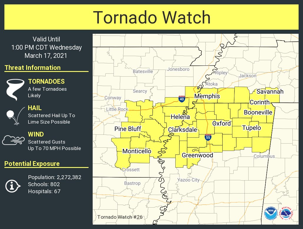
First Tornado watch of the day
Posted on 3/17/21 at 6:09 am to GEAUXmedic
SPC summary from 1 AM....
[quote] Forecast Discussion SPC AC 170552 Day 1 Convective Outlook NWS Storm Prediction Center Norman OK 1252 AM CDT Wed Mar 17 2021 Valid 171200Z - 181200Z ...THERE IS A HIGH RISK OF SEVERE THUNDERSTORMS FROM NORTHEAST LOUISIANA ACROSS NORTHERN MISSISSIPPI INTO NORTHWEST ALABAMA...
...SUMMARY...
A regional outbreak of severe storms is expected today and tonight across portions of the lower Mississippi Valley into Alabama. Widespread severe storms capable of producing tornadoes (several of which may be intense), very large hail and intense damaging wind gusts are expected. More than one round of severe storms are possible across parts of Mississippi into Alabama during the afternoon into the overnight hours. .
..Lower Mississippi Valley to Alabama...
Early-morning water-vapor imagery depicts a well-defined upper low over central NM moving east toward the TX Panhandle. This feature will eject across OK into the Ozark Plateau by the end of the period. Intense large-scale forcing for ascent is currently spreading across the southern High Plains region where deep convection is currently expanding in areal coverage along the dry line/Pacific front as it encounters western edge of moisture plume. This boundary will remain active leading into the start of the day1 period. Strongly diffluent flow aloft will overspread the lower MS Valley/central Gulf States during the day as 80kt+ 500mb flow overspreads increasingly moist/buoyant warm sector. Latest model guidance suggests several LLJ segments will increase ahead of the trough, each likely modulating bouts of organized severe thunderstorm clusters/supercells. The primary synoptic low is forecast to track across northeastern OK into southern MO. Significant elevated convection will be noted north of the warm front but ample surface-based buoyancy/shear south of the front should prove favorable for supercells as one LLJ segment focuses across AR into southeast MO ahead of this feature. At the same time, a secondary LLJ will strengthen across MS during the day and become the primary LLJ into the overnight hours over northwestern AL/middle TN. This secondary LLJ appears to be responding to a mid-level speed max that will translate across south-central TX into southern LA during the late evening hours. Of particular interest is the boundary-layer moisture that is now present along the Gulf Coast where lower 70s surface dew points are observed. This air mass will advance north during the day and diurnal heating will allow moderate instability to develop along a corridor from southern LA through central MS into western AL where SBCAPE should be on the order of 2500 J/kg. While the primary 500mb speed max will likely maintain convection along the surging Pacific front over southeast TX, an uncapped, buoyant air mass downstream over MS/AL should prove favorable for discrete supercell development ahead of the primary short wave. Forecast soundings across the HIGH Risk exhibit profiles favorable for strong, long-track tornadoes, and this is especially true from northeast LA through northern MS into northwest AL.[/quote]
Posted on 3/17/21 at 6:11 am to East Coast Band
Stay safe today guys

Posted on 3/17/21 at 6:13 am to East Coast Band
This has me nervous to drive from NOLA to Fairhope late this afternoon.
Posted on 3/17/21 at 6:14 am to theOG
Calm before the storm out in East Memphis area.
Dog is freaking out and hasn’t started raining here.
Dog is freaking out and hasn’t started raining here.
Posted on 3/17/21 at 6:15 am to Rebel
Can hear Thunder in the distance.
Posted on 3/17/21 at 6:15 am to East Coast Band
quote:[/quote]
into northwest AL.
Not Central?

Posted on 3/17/21 at 6:33 am to blzr
quote:
Not Central?
The high risk doesn’t extend into central AL at this time, but most of Alabama is in a moderate risk so the threat is still major in AL even outside of the high risk. I expect the high risk to be expanded further east later today.
This post was edited on 3/17/21 at 6:34 am

 Page 18 of 64

Popular
Back to top